Geography Notes Form 3
Geography Notes Form 3 - KLB Book 3 - KCSE Geography Revision Notes - Free Download
Statistics
Compound/cumulative/divided
Bar Graph
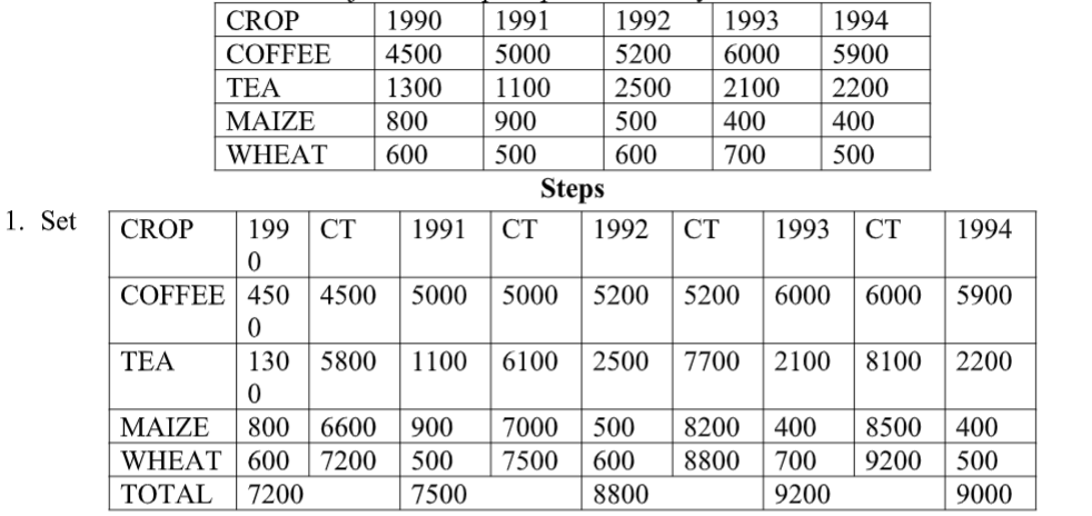
Major Cash Crops Exported in Kenya in Tonnes
2. Draw vertical axis(Y) to represent dependent variable
3. Draw horizontal axis(x) to represent independent variable
4. Label both axis using suitable scale
5. Plot the cumulative values for each year
6. Use values for components to subdivide the cumulative bar
7. The subdivisions are placed in descending order with the longest at the bottom(coffee)
8. Shade each component differently
9. Put title and key
Advantages
1. Its easy to construct
2. It has good visual impression
3. There is easy comparison for the same component in different bars because of uniform shading
4. Easy to interpret because bars are shaded differently
5. Total value of the bar can be identified easily
Disadvantages
1. It doesn’t show the trend of components (change over time).
2. Cant be used to show many components as there is limited space upwards
3. Tedious as there is a lot of calculation work involved.
4. Not easy to trace individual contribution made by members of the same bar
5. Poor choice of vertical scale causes exaggeration of bars length leading to wrong conclusions
- Coffee was the leading export earner in the five years.
- Tea was the second leading export earner.
- Wheat had the lowest export quantity.
- 1993 recorded the highest export quantity.
- 1990 recorded the lowest export quantity.
Piechart/dividedcircles/circle Charts
- A circle which has been subdivided into degrees used to represent statistical data where component values have been converted in degrees. Major countries producing commercial vehicles in the world in 000s

USA 1800×360/5480=118.2◦
FRANCE 240×360/5480=15.8◦
JAPAN 2050×360/5480=134.7◦
UK 400×360/5480=26.3◦
GERMANY 240×360/5480=15.8◦
RUSSIA 750×360/5480=49.3◦
b) Draw a circle of convenient size using a pair of compasses.
c) From the centre of the circle mark out each calculated angle using a protractor.
d) Shade the sectors differently and provide the key for various shadings.
Advantages
1. Gives a good/clear visual impression
2. Easy to draw.
3. Can be used to present varying types of data e.g. minerals, population, etc.
4. Easy to read and interpret as segments are arranged in descending order and are also well shaded.
5. Easy to compare individual segments.
Disadvantages
1. Difficult to interpret if segments are many.
2. Tedious due to a lot of mathematical calculations and marking out of angles involved.
3. Can’t be used to show trend/change over a certain period.
4. Small quantities or decimals may not be easily represented.
Analysis
1. The main producer of commercial vehicles is Japan.
2. The second largest producer is USA followed by Russia.
3. The lowest producers were France and West Germany with.
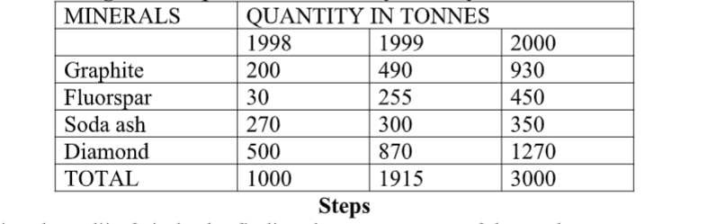
This is use of circles of various sizes to represent different sets of statistical data. Table showing mineral production In Kenya from year1998-2000
1998 √1000=31.62=32
1999 √1915=43.76=44
2000 √3000=54.77=55
2. Scale:1cm represents 10 tonnes
1998=3.2 cm
1999=4.4 cm
2000=5.5 cm
3. Using a pair of compasses draw circles of different radii representing mineral production in Kenya between 1998 and 2000.
4. Convert component values into degrees
Component value/ total value of data×360
1998: Graphite-200/1000×360=72◦
Fluorspar-30/1000×360=10.8◦
Soda ash-270/1000×360=97.2◦
Diamond-500/1000×360=180◦
1999: Graphite-490/1915×360=92.1◦
Fluorspar-255/1915×360=47.9◦
`300/1915×360=56.4◦
Diamond-870/1915×360=163.6◦
2000: Graphite-930/3000×360=11.6◦
Fluorspar-450/3000×360=54◦
Soda ash-350/3000×360=42.1◦
Diamond-1270/3000×360=152.3◦
5. On the proportional circle for each year use a protractor and mark out the angles 6. Shade the segments and then provide a key.
Advantages
1. They give a good visual impression.
2. Easy to compare various components.
3. Simple to construct.
4. Easy to interpret as segments are arranged in descending order.
5. Can be used to present varying types of data.
Disadvantages
1. Tedious in calculation and measurement of angles
2. Actual values represented by each component cant be known at a glance
3. Difficult to accurately measure and draw sectors whose values are too small.
4. Comparison can be difficult if the circles represent values which are almost equal.
Analysis/Conclusions
1. Diamond was leading in production.
2. The second leading mineral in production was graphite.
3. The mineral with the lowest production was fluorspar.
Map Work Description of Relief
a) Describe the general appearance of the entire area e.g. hilly, mountainous, plain, undulating landscape, has many hills, isolated hills, etc.
b) State the highest and lowest parts of the area.
c) Look out for valleys which are occupied by rivers.
d) Divide into relief regions such as plateau, escarpment and lowland.
e) Explain the type of slop e.g. gentle, steep, even or irregular.
f) Direction of slope.
g) Identify the land forms present in the area.
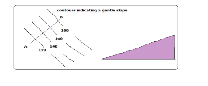
Gentle Slope
Slope is the gradient of land surface.
Gentle slope is one in which land doesn’t rise or fall steeply Contours are wide apart
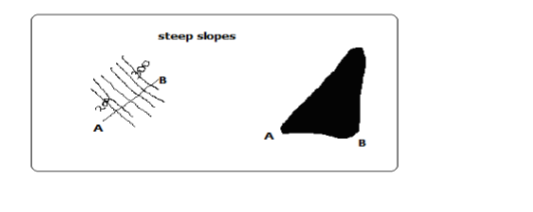
- Where land rises or falls sharply
- Contours are close to each other
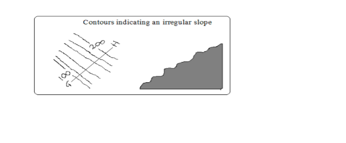
- Shown by contours which are evenly spaced.

- Indicated by unevenly spaced contours.
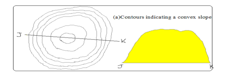
- One curved outwards
- Indicated by contours which are close together at the bottom and widely spaced together at the top.
- One curved inwards.
- Contours are close together at the top and widely spaced at the bottom.

- A low area between higher grounds.
- Indicated by U-shaped contours pointing towards a higher ground.
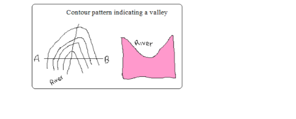
- Land which is projected from high to low ground.
- Indicated by U-shaped contours bulging towards lower ground.

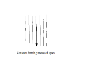
- Spurs which appear as if to fit together.
- Spurs in glaciated highlands whose tips have been eroded and straightened.
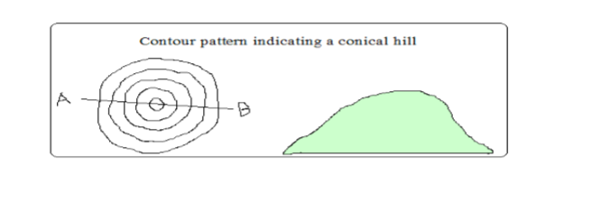
- Hills are uplands which rise above relatively lower ground
- Conical hills are small rounded hills
-A hill with some sides with uneven gentle and others with uneven steep slopes.
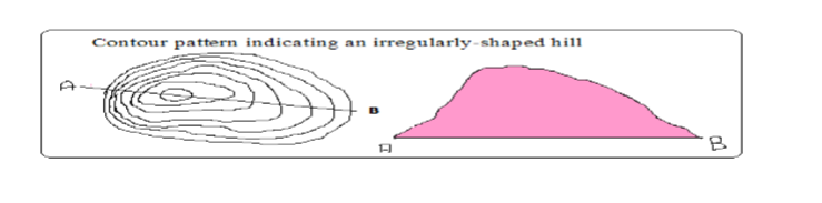
- A range of hills with steep slopes on all sides.
- A ridge can contain hills, cols, passes or water shed.
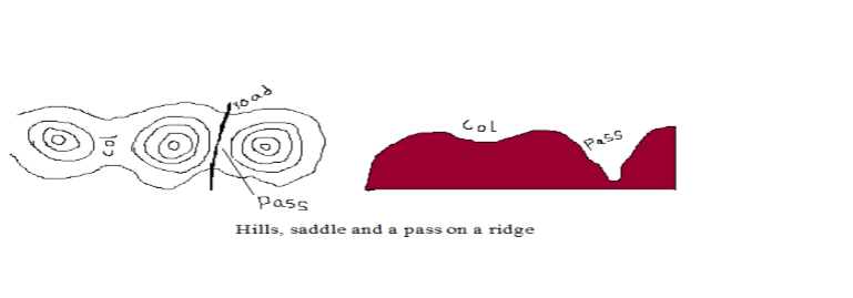
- A low area which occurs between two hills.
A Pass
- A narrow steep sided gap in a highland.
A Water Shed
- The boundary separating drainage systems which drains into different directions
- Escarpment and ridges often form water sheds.

- A relatively continuous line of steep slopes facing the same direction
- Has two slopes: a long gentle slope (dip slope) and short steep slope (scarp slope).

- A high flat land bound by steep slopes.

Natural vegetation is classified as woodlands, thickets, scrubs or grasslands.
Symbols are given as pictures of vegetation.
• Types present
• Distribution
• Reasons for distribution e.g. seasonal streams, scrub or grassland due to low rainfall.
a) Forests
Likely indications of the following in the area:
• Heavy rainfall
• Fertile rainfall
• Cool temperature depending on altitude
b) Thickets and shrubs
• Seasonal rainfall
• Poor soil
• High temperature
c) Riverine trees
• High moisture content in the river valley
Describing Drainage
• Identify drainage features present
Natural drainage features include lakes, rivers, swamps, sea, rapids, water falls, cataracts, springs, deltas, fjords, sand or mud, and bays Artificial features include ponds, wells, boreholes, water holes, cattle dips, cattle troughs, canals, reservoirs, irrigation channels, aqueducts, water treatment plants and man made lakes.
• Identify main rivers by name
• Size of rivers-big or small-shown by thickness of blue lines.
• Give the general direction of flow.
• Location of water shed if any
• Characteristic of each feature
a) Permanent Rivers
- Which flow throughout the year
- Shown by continuous blue lines

- Heavy rainfall
- Impermeable rocks
b) Seasonal Rivers
- Which flow seasonally or during the rain season
- Shown by broken blue lines

- Low rainfall
- River doesn’t have a rich catchment area
c) Disappearing Rivers
Blue lines ending abruptly

- Permeable rocks
- Very low rainfall
- Underground drainage
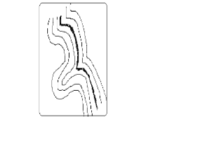
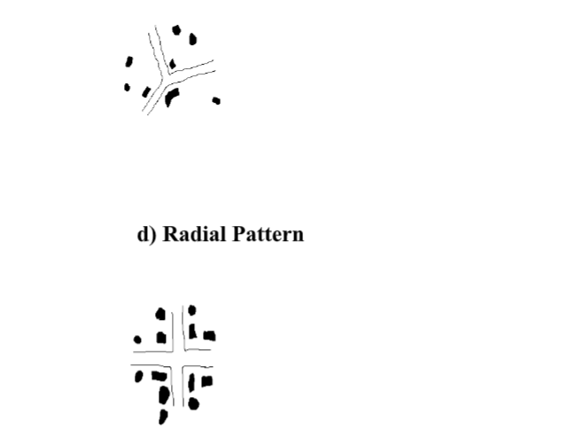
• Identify drainage patterns and description
-Drainage pattern is the layout of a river and its tributaries on the landscape.
a) Dendritic
-Resembles a tree trunk and branches or veins of a leaf.
-Tributaries join the main river at acute angles.
Tributaries join the main river and other tributaries at right angles of hard and soft rocks)
Common in folded areas where rivers flow downwards separated by vertical uplands.
-Looks like a large block of rectangles.
-Tributaries tend to take sharp angular bends along their course.

-Rivers and tributaries flow virtually parallel to each other Influenced by slope
-Common on slopes of high mountain ranges

-Rivers flow from many directions into a central depression such as a lake, sea or swamp.
-Examples are rivers flowing into some of the Rift Valley lakes such as Nakuru and Bogoria.

Streams (rivers which are small in size) are arranged in series of curves about a basin or crater
It’s controlled by the slope.
f) Radial
-Resembles the spikes of a bicycle
-Formed by rivers which flow downwards from a central point in all directions such as on a volcanic cone e.g. on Mt. Kenya, Elgon and Kilimanjaro.
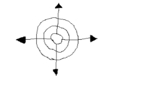
- Flow of river is guided by direction of fault lines

Description of Human Activities
• Identify types
• Evidence –man made features
• Reasons e.g. tea-cool temps and heavy rainfall
Agriculture a) Plantation farming
Evidenced by presence of:
-“C”-coffee
- Named estates e.g. Kaimosi tea estate
b) Small scale crop farming
- Cotton ginnery or sheds
- Coffee hullerlies
- Posho mills for maize, millet, sorghum
- Tea factory/store
Livestock Farming
- Dairy farms
- Veterinary stations
- Cattle dips
- Creameries
- Water holes
- Dams
- Butcheries
- Slaughter houses
Mining
- Symbol for a mine/mineral works
- Name of the mine
- Particular mineral e.g. soda ash
- Quarry symbol
- Processing plant of a mineral e.g. cement indicates cement is mined in that area
Forestry/Lumbering
- Saw mills
- Forest reserves
- Forest station
- Forest guard post
- Roads ending abruptly into a forest estate used to transport logs to saw mills
Fishing
- Fish traps
- Fishing co-operative society
- Fish ponds
- Fish hatcheries
- Fisheries department
- Fish landing grounds(banda)
Manufacturing/Processing Industry
- Saw mills for lumber products
- Ginnery for cotton processing
- Mill for maize, millet, wheat processing
- Creameries for milk processing
- Factory for manufacturing or processing a known commodity.
Services
a) Trade
- Shops
- Markets
- Stores
- Trading centres
b) Transport
i) Land
- Roads
- Other trucks and foot paths
- Railways, station, sliding, level crossing lines and railways light
ii) Air
- Air fields
- Airports
- Air strips
iii) Water
- Ferries
- Bridges
c) Communication
- Post offices(P.O.)
- Telegraph(T.G.)
- Telephone lines(T)
d) Tourism
- Camping sites
- Tourist class hotels and restaurants
- National parks
- Game reserves
- Curio shops
- Museums
- Historical monuments
e) Administration
- DO, DC, PC, police post, chiefs camp.
Social Services
a) Religious Services
- Church
- Mosque
- Temples
b) Education
- Schools
- Colleges
- Universities
c) Health Services
- Hospitals
- Dispensaries
d) Recreational Services
- Golf clubs/courses
- Stadiums
Description of Settlement
A settlement is a place with housing units where people live together
• Densely distributed settlements- high concentration of settlements(black dots)
• Moderately distributed settlements- settlements moderate in quantity
• Sparsely distributed settlements-few settlements spread over a large area.
• Very sparse if very few
• Identify type of settlement patterns present
• Type of Settlements
a) Rural settlements
Consist of villages and homesteads and homesteads in which people are involved in subsistence agriculture and traditional activities such as pottery weaving, curving, etc.
b) Urban settlement
Consist of dense permanent and sometimes high buildings and population engaged in non agricultural activities such as industrial activities.
Factors Influencing Settlement
1. Physical Factors
a) Climate
Areas with moderate temps and adequate rainfall are densely settled while those with extremely low or high temps have fewer settlements.
b) Relief
Terrain: Steep slopes are less settled due to thin soils and difficulty to erect buildings.
Aspect: Slopes facing away from the sun in high latitudes are less settled than those facing the sun.
Wind ward slopes of mountains on the path of rain bearing winds are more settled due to heavy rainfall making them ideal for agriculture.
c) Drainage
Rivers and springs attract settlements because they provide clean water.
Areas with drainage swamps are less settled because it’s difficult to erect buildings and they also harbour mosquitoes and snails which cause diseases.
d) Vegetation
Dense forests discourage settlements because of wild animals and also harbour disease vectors such as tsetse flies e.g. Miombo woodland of Tanzania and Lambwe valley in Kenya.
e) Pests and diseases
Areas prone to pests and diseases are less settled because people like to live in healthy environment.
f) Natural resources
Settlements start where there is mineral extraction. e.g. Magadi Lakes with abundant fish may also attract settlement.
g) Human Factors
i) Political factors
- 1967 TZ settled peoples in villages and the rest of land was left for farming (Ujamaa villages)
- After independence Kenya settled its landless in settlement schemes e.g. Mwea, Laikipia, Nyandarua.
- Settlement of refugees in refugee camps due to political upheavals
ii) Historical factors
- Weaker communities were forced to move elsewhere by wars.
- Settlement of communities in strategic sites such as hilltops or plateaus to see approaching enemies e.g. Fulani of Nigeria in Jos plateau.
iii) Cultural factors
- Farming communities settled in agriculturally productive areas. - Pastoralists settle in areas with enough land to provide pasture for their animals at ease.
iii) Economic factors
- Rural to urban migration for employment and trading.
- Mining activities may lead to development of settlements e.g. Magadi due to trona mining.
Types of Settlements Patterns
a) Nucleated/Clustered Settlement Pattern

Factors
• Availability of social amenities such as schools and health care
• Shortage of building land
• Favourable climate leading to high agricultural potential e.g. Kenya highlands.
• Fertile soils.
• Presence of natural resources e.g. minerals in Magadi, Mwadui, Kimberly.
• Security concern especially in banditry prone areas.
b) Linear Settlement

• Presence of a transport line e.g. road or railway.
• Presence of a river or a spring to provide water for domestic or commercial use
• Presence of a coast line which has a favourable fishing ground e.g. shore of E. African coast.
• Suitable terrain for cultivation of crops such as at the foot of a scarp
c) Dispersed/Scattered Settlement
- Buildings are scattered
• Plenty of land to build whenever they want
• Avoidance of harsh climate e.g. arid and semi-arid areas.
• Poor infertile soils.
• Pests and diseases.
• Physical features such as ridges, valleys which separate houses.
- Common at cross roads where housing units point in all directions.
Enlargement and Reduction of Maps
Steps
1. Identify the area requiring to be enlarged
2. Measure its length and width
3. Multiply (E) or divide (R) the by the number of times given.
The scale also changes e.g.1:50000/2(enlarged)×2(reduced)
4. Draw the new frame with new dimensions
5. Insert the grid squares e.g. 2×2cm, 2/2, etc.
6. Draw diagonals on the frame
7. Transfer features exactly where they were
Drawing a Cross Section/Profile
- Line drawn on a piece of paper showing the nature of relief of a particular area.
Steps
1. Identify the given points and name them A and B
2. Joint point A and B using a pencil
3. Take a piece of paper and fold it into two parts
4. Place the papers edge along the line joining A and B
5. Mark all contours and their heights
6. Mark features along A-B e.g. R- river, H- hill, M- mountain
7. Determine the highest and lowest contour height to determine the appropriate vertical scale
8. Draw horizontal axis and mark it A-B
9. Draw vertical axis from A to B
10. Place the edge of folded paper along horizontal axis
11. Use values along vertical axis to plot contour heights.
Remember to show features marked along A-B
12. Join plotted points using smooth curve (cross Section)
13. Include title on top vertical and horizontal map scale.
Calculation and Interpretation of Vertical Exaggeration and Gradient Vertical Exaggeration
Number of times that the vertical scale is larger than horizontal scale
V.E. =Denominator of H.S. /D. of V.S. (cross section scale.
e.g. V.S. =1:20M
H.S=1:50000
V.E.=50000/20×100 (To convert into cm) =25
Interpretation
The vertical height has been exaggerated 25 times compared to the horizontal distance Intervisibility
Ability of one place to be seen from another
Steps
• Draw cross section
• Join points A-B using visibility line
• If the visibility line is above the cross section, the two points are intervisible. If below they are not intervisible.
Gradient
Degree of steepness of a slope between two given points
Steps
1. Identify the two points
2. Calculate difference in height between the two points(Vertical Interval) e.g. 500m
3. Joint them with a light line
4. Measure ground distance between the two points(Horizontal Equivalent)e.g.12 cm G=V.I./H.E.
=500×100/12×50000=50000/600000=1/12=1:12
Interpretation
For every 12 m travelled on the Ground, there is a vertical rise of 1m
External Land Forming Processes
- Processes operating on the exterior of the earth resulting in the formation of natural physical features.
These are:
1. weathering
2. mass wasting
3. erosion
4. transportation
5. deposition
Weathering
- Mechanical breakdown or chemical decay of rocks “in situ” (without movement)
Agents of weathering
- Things that work to cause it:
1. Weather elements:
- rainfall
- temperature
- frost
- gases e.g. CO2,O2
2. Plants
3. Animals
4. People
Factors That Influence Weathering Climate
- Different areas with different climatic elements experience different types of weathering e.g. block disintegration are experienced in arid areas while frost action is experienced in temperate regions and mountainous regions of tropics.
Topography
- Weathering is faster on steep slopes than on gentle slopes because weathered material is washed away quickly exposing the rock once again to agents while on gentle slopes materials remain in one position shielding the rock from weathering agents.
Nature of rocks
- Dark coloured rocks absorb more heat than light coloured ones hence break faster due to excessive expansion and contraction.
- A rock with different minerals may disintegrate faster due to differential expansion and contraction of minerals.
- A well jointed rock will break faster because physical and chemical agents can penetrate faster e.g. by freezing and thawing.
- Fine textured rocks have a large surface area on which chemical processes can act e.g. Limestone.
Biological organisms
- Bacteria facilitate rotting of organic matter producing organic acids which reacts with some minerals causing the rock to break up.
- Plant roots and burrowing animals penetrate rocks resulting in cracks providing passage for agents such as water to act on rocks.
- People accelerate the rate of weathering by exposing rocks buried deep below by digging, blasting and drilling.
Types of Weathering
1. Mechanical Weathering
- Physical break up of rocks without change in their chemical composition.
Processes
a) Block Disintegration/Separation

- It’s effective in arid areas because of great diurnal temperature range.
- Day, well jointed rocks are subjected to intense heating causing minerals in it to expand.
- In the night the rock is cooled causing it to contract.
- The rock joints enlarge due to the alternating cooling and contraction.
- The process is repeated over a long time causing the rock to disintegrate into blocks along the joints e.g. Mundanda rock in Tsavo East.
b) Exfoliation
- Also common in arid areas.
- Day, rock surface is heated more than inner layers because rocks are poor conductors of heat.
- The surface expands more than inner layers causing strain between the two layers.
- With time outer layer develops cracks and later peels off and pieces of rocks fall down under gravity e.g. along Mombassa-Nairobi road between Mtito Andei and Voi.
c) Granular Disintegration
- Disintegration of rocks into grains.
- Occurs in rocks with different minerals.
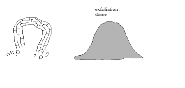
d) Pressure Release/Sheeting/Unloading
- Soil and other materials lying on top of a rock are removed by erosion and mass wasting (denudation).
- The exposed rock expands when the weight that was pressing it is removed.
- The outer layer curves and eventually shells are pulled out from the rock.
- The result is formation of a high rocky hills called granitic tors e.g. Maragoli and parts of Machakos.
e) Frost Action
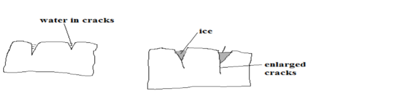
- Common in temperate regions or mountainous regions of tropics where temperature fall below zero.
f) Crystal Growth
- Break up of rocks due to crystal growth.
g) Slaking/Rain Water Action
- Breaking up of sedimentary rocks due to alternate wetting and drying.
2. Chemical Weathering
a) Solution
b) Carbonation
- Weathering caused by reaction of calcium carbonate in rocks with rain water containing a weak carbonic acid.
- Common in temperate regions.
- Rain water absorbs small quantities of carbon dioxide forming a weak carbonic acid.
H2O+CO2->H2CO3
- The weak carbonic acid falls on limestone rocks reacting with calcite forming calcium bicarbonate.
CACO3+H2CO3->CA (HCO3)
- Calcium bicarbonate is removed from the rock in solution.
c) Hydrolysis
- Weathering caused by reaction of hydrogen ions of water and ions of rock minerals.
- Igneous rocks are greatly affected.
d) Oxidation
- Weathering in which minerals in rocks combine with oxygen in the presence of moisture to form new minerals.
- Rocks containing iron are affected.
- Ferric oxide is formed on the rock surface which appears as a soft brown or red earth which can be scooped by hands.
e) Hydration
- Weathering in which hygroscopic minerals in rocks take up water causing them to swell and expand causing disintegration of rock due to internal stress.
3. Biological Weathering
- Weathering of rocks due to action of living organisms on them.
a) Action of plants
Mechanical
Chemical
c) Animals excrete on rocks and release chemical substances which react with some minerals in rocks causing them to break up.
d) Chemical substances released from the industries to rivers cause the water to act on rocks over which it flows.
e) Gases such as CO2 emitted from motor vehicles and industries
f) Absorbed by rain and acids such as carbonic or sulphurous which react with minerals causing rock to decay.
Significance of Weathering
Positive
1. Leads to soil formation which is important for agriculture.
2. Produces other natural resources such as clay used in pottery, brick making, etc.
3. Weathered rocks form beautiful scenery for tourist attraction e.g. Hells Gate and crying stones of Kakamega.
4. Weakens rocks easing their exploitation by quarrying and mining
Negative
1) May weaken the earths crust resulting in unstable foundations of buildings and roads and eventually lead to their collapse.
Mass Wasting
- Movement of weathered material down slope under the influence of gravity
Factors Influencing Mass Wasting
a) Degree of slope
- Movement of weathered material is faster on steep slopes than on gentle slopes due to the influence of gravity.
b) Climate
- Weathered material in areas receiving heavy rainfall move faster since wet materials have less cohesion.
c) Nature of the material
- Material saturated with water is more likely to move down slope as its heavy.
- Mass wasting is more likely to occur in areas where the weathered material is deep.
- Weathering is more likely where massive rocks lie on weak rocks such as clays, shale than where fine materials lie over weak rocks.
Vegetation
- Surfaces with vegetation experience less mass wasting because it binds weathered material together.
Tectonic movements
- Earth movements such as earthquakes, volcanic eruptions or faulting cause large and widespread mass wasting.
Human activities
- Explosives used in mining and quarrying shake the ground initiating downward movement of materials.
- Mining and quarrying also interferes with the stability of the surface by loosening it making it easy for the loosened materials to move down slope.
Types of Mass Wasting
1. Slow Mass Wasting
- Slow but steady movement of soil or loose rock debris down slope.
Processes
a) Soil Creep
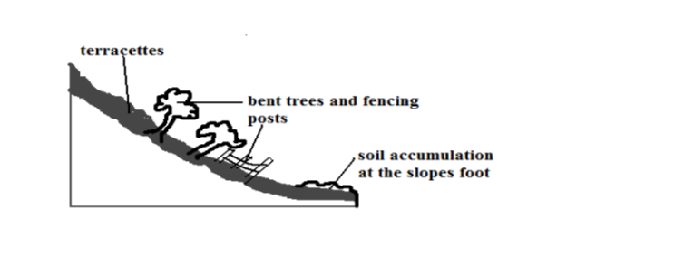
Causes
1) Alternate heating and cooling causing expansion and contraction of particles causing them to change their positions.
2) Alternate wetting and drying of soil whereby when it’s wet its compact and when dry the particles are loosened and tend to move away from each other.
3) Trampling and burrowing of animals.
4) External forces e.g. shaking by earthquakes, explosives, heavy vehicles, etc.
5) Ploughing down hill
6) Freezing of soil water causing it to expand which lifts particles at right angles to the slope in a process called heaving.
b) Solifluction
- Movement of saturated soil, gravel and weathered rock down a moderate slope.
- Common in mountainous and very cold climates
- Thawing occurs during spring causing top soil to become saturated.
- Saturated soil begins to creep over the subsoil which still remains frozen(permafrost).
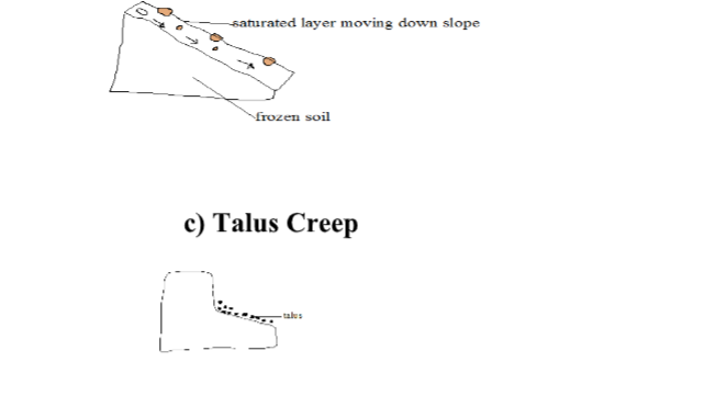
d) Rock Creep
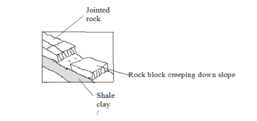
2. Rapid Mass Wasting
- Type of mass wasting involving large amounts of weathered material moving suddenly and fast down slope.
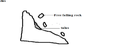
a) Mud Flow
- Movement of oversaturated weathered material inform of liquid down slope.
- It occurs mainly in dry areas after heavy rains.


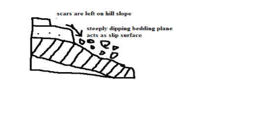
c) Land Slide
- Sudden slipping of large quantities of loosened surface rock or soil down a slope.
d) Slump

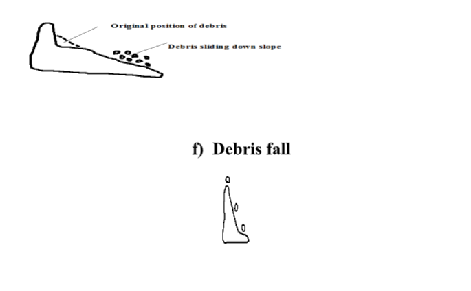
e) Debris Slide
- Sudden downhill movement of accumulated rock debris and other loose material downhill as a whole
g) Rock Slide
h) Rock fall
- Most rapid of all mass wasting.
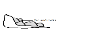
h) Avalanche
- Sudden slipping and falling of a large mass of snow, ice and loose rock materials down a mountain side.
- Type of mass wasting involving removal of weathered materials by rain water.
Types
a) Sheet wash
- Uniform removal of soil from a large area.
Its common around L. Baringo and Marigat.
b) Gulleying
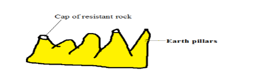
Rain falls on an even slope
The water irregularly runs down slope along specific channels called rills.
The channels are widened and deepened by the water to form gullies.
Neighbouring gullies are widened and the ridges between them are reduced to form earth pillars.
d) Splash erosion
- Removal of soil by rain drops scattering loose particles and carrying them down slope by runoff.
Effects of Mass Wasting On Physical and Human Environment Positive
1. Make the soil to become fertile where soil from fertile areas is deposited.
2. Leads to formation of new land forms such as scars, depressions, lakes, rock pillars, etc.
Negative
1. Soil creep may destroy walls built across the slope when creeping soil exerts pressure on them.
2. Decrease soil fertility where fertile soil moves down slope.
3. Makes the ground prone to soil erosion especially where scars have formed.
4. Hinders transport and communication by blocking railway lines making maintenance to be costly.
5. Hinders mechanisation of agriculture e.g. gulleying does not allow movement of vehicles and machinery on farms.
6. Leads to destruction of property and loss of live by burying people in their houses and stones falling on escarpments along roads causing accidents.
7. May Cause Rivers to change their courses e.g. mud flow.
Hydrological/water Cycle
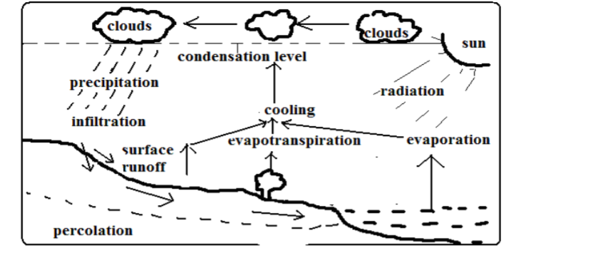
Processes in Which Circulation Is Carried Out
1. Evaporation
- Changing of water into water into water vapour when it’s heated by solar radiation.
Evapotranspiration: Combined loss of water from the soil through direct evaporation and transpiration by plants.
2. Cooling
- Reduction of water vapour temperature as it rises into the atmosphere when it expands due to reduced temperature and pressure.
3. Condensation
- Turning of water vapour into tiny water droplets which form clouds when cooling continues below dew point.
4. Precipitation
-The process in which the earth receives moisture from the atmosphere.
It occurs when droplets formed by condensation combine forming heavier drops which fall on the ground as rain or may become frozen to form snow, hail, sleet, etc.
5. Surface runoff
- Some of the water from precipitation that flows on the surface into valleys, ponds, lakes, etc.
6. Infiltration
- Entry of water into the ground through pores, joints and cracks in rocks.
7. Percolation
- Downwards and sideways movement of water that has entered into the ground.
8. Overland flow
Surface runoff makes the overland flow.
River water flows back to the oceans where evaporation takes place again and water cycle is repeated.
Significance of Hydrolological Cycle
Positive
1. Provides water to man from precipitation and underground water.
2. Provides rain to man who is useful in agriculture.
3. Atmospheric water is important in regulating heat loss from the earth by absorbing terrestrial radiation and reflecting it back to the earth keeping the lower atmosphere warm.
Negative
1. May lead to shortage of water when evaporation rate exceeds precipitation.
2. May lead to decreased agricultural production as a result of excessive evaporation causing weathering of crops.
3. May lead to flooding when excessive evaporation cause increased rainfall.
4. May lead to shortage of rainfall if there is less evaporation due to low temperature.
Action of Rivers
A river is a mass of water flowing over the land in a definite channel.
Work of a River
1. Drain excess water from the land.
2. Sculpturing land through erosion, transportation and transportation.
River Erosion
- Removal by river water of materials from the sides and bed of the river channel.
Factors Influencing River Erosion
1. River volume
- A river with a large volume has a greater kinetic energy to erode than one with a small volume.
2. Slope of land
- A river flowing on a steep channel has greater velocity and therefore more energy to erode its channel than one flowing over gentle or flat land.
3. Rivers load
- A river with large, rough and heavy load e.g. tree trunks and boulders erodes more than one with light, fine and smooth materials e.g. sand.
- A river carrying more load erodes more than one with less load as it has more abrasive tools.
4. Nature of bed rock
- Erosion is faster where a river flows over soft bed rock and less where it flows over hard rock.
Processes/Ways of river erosion
1. Solution/Corrosion
- River water dissolving soluble minerals and carrying them away.
2. Hydraulic Action
- Erosion by the force of river water when it thrusts itself into cracks and joints of rocks on the sides of the channel dislodging lumps.
- Also by pushing air into the cracks, compressing it increasing pressure which widens the cracks eventually dislodging lumps.
3. Abrasion/Corrasion
- Abrasion is scratching of the bed and banks by materials are carried away by the river.
- Corrosion is hurling of rock fragments carried by the river against rocks which weaken and eventually break them.
4. Attrition
- Hitting against one another of rock fragments carried by river water breaking one another into smaller pieces.
Types of River Erosion
1. Vertical Erosion
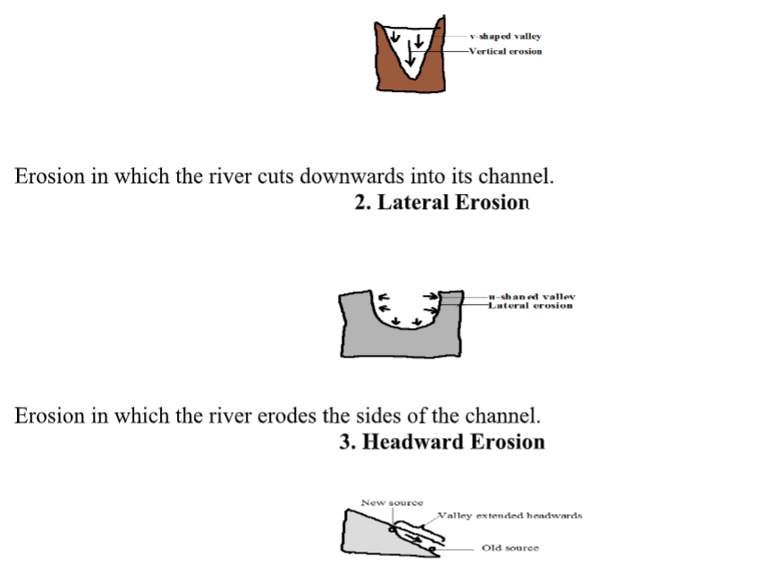
a) Where there is a water fall.
o The river undercuts at the base of a waterfall.
o The rock above the undercut cliff collapses.
o The position of waterfall shifts upstream.
b) Where gulleying or soil creep occurs where there is a spring causing its position to shift upstream (spring sapping).
Resultant Features of River Erosion
1. Stream Cut Valleys
- Valleys with V, open V or U shaped cross sections along the river channel.

2. Gorges
- Narrow, deep, steep-sided valley.
Ways/modes of formation
a) Where a river flows along a fault or a section of soft rocks eroding the channel vertically through the soft rocks or fault.
b) By headward erosion at a water fall when the river’s erosive activity is increased due to increased gradient causing the river to undercut at the base of the water fall, then the rock above the undercut base collapses causing the waterfall to shift upstream resulting in a gorge below the water fall.
c) Where a river flows across a plateau with alternating horizontal layers of hard and soft rocks eroding them resulting in a gorge with stepped sides called a canyon e.g. Grand canyon on R. Colorado in USA.
d) Due to river rejuvenation when the river’s erosive activity is renewed causing the river to vigorously erode deep into its channel.
e) Where a river maintains its course across land which is being uplifted gradually.
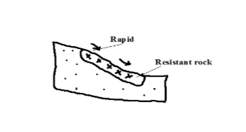
Rapids
- A section of the rivers course where the bed is suddenly steepened causing the water to suddenly flow swiftly.
How they are formed
a) Where a less hard rock lies below a soft rock and the soft rock is eroded more resulting in a steep slope.
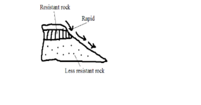
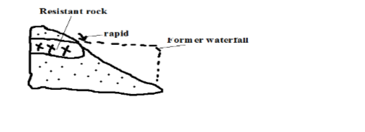
- A place on a rivers course where a river bed is vertical or nearly vertical.
Formation
a) Where a river descends over a sharp edge of a plateau encountering a sharp drop.
b) Where a river descends a cliff into the sea.
c) Where a river descends a fault scarp.
d) Where a river descends a sharp edge of a plateau.
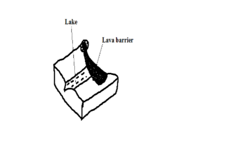
e) Where a river is blocked by lava flow causing water to accumulate on the upstream side and a water fall forms at the point of overflow.
f) Where a resistant rock lies across a river with a less resistant one on the downstream side and the less resistant one is eroded faster causing a rapid to be first formed, then a waterfall.

- Circular depressions on a river bed.
- Form where a river flows over shallow depression and develops strong circulating currents which cause the load to scratch the bed in circular motion.
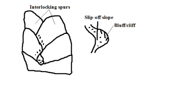
Formation
- Where In the youthful stage, a river flows around spurs undercutting the outer bank more than the inner bank causing the bends to be more pronounced making the spurs to appear as if to fit together.
The outer bank becomes river cliff/bluff and the inner bank slip off slope.
River Transportation
- River carrying away materials that its water has eroded from the channel.
Factors Influencing River Transportation
a) Rivers Volume
A river with large volume of water has more energy and therefore greater carrying ability than one with a small volume.
b) Gradient
A river flowing on a steep channel has greater ability to transport than one on a gentle slope because it flows fast due to gravity.
c) Rivers Load
- Small and light particles are transported over long distances while heavy materials are transported for a short distance.
- Dissolved load is carried all the way to the rivers mouth.
- Small amount of load is transported for a long distance while large amounts of load collide reducing the speed and therefore rivers ability to transport causing some of the load to be dropped along the way.
Processes/ways of River Transportation
a) Suspension
- River transportation of light and insoluble materials in form of a mixture.
b) Saltation/Hydraulic Lift
- River transportation of large particles through a series of jumps and hops.
c) Traction
- River transportation of heavy materials like boulders by rolling them by the force of water.
d) Solution
- River transportation of load in solution form.
Load transported by suspension, Saltation and traction is called clastic load while that by solution is called dissolved load.
Deposition
- Laying down of some of the load carried by the river when energy decreases.
Factors Influencing Deposition
a) Gradient
When gradient reduces the river’s speed decreases and hence its energy is reduced causing it to drop some of the heavy load.
b) Rivers Volume
When rivers volume decreases its energy also decreases causing it to deposit heaviest load then lighter ones.
c) Obstacles
Obstacles such as swamp vegetation and rock outcrop reduce the river’s speed and also trap some of the load thereby facilitating deposition.
d) River Bed Width and Depth
Where a rivers channel becomes wide and shallow there is less water per unit area and hence the river has lower capacity to transport so deposition of excess load begins.
Resultant Features of River Deposition
a) Alluvial Fans and Bajadas
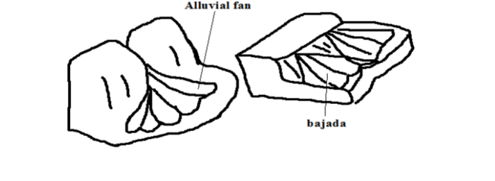
Formation
b) Meanders and Oxbow Lakes
Meanders are loop-like bends in a rivers course.
Oxbow lake is a horse shoe shaped section of a former river.
Formation


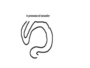


Formation
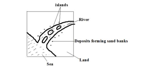
River Braids

Factors favouring formation of braids
a) River must be carrying large load.
b) Reduced gradient on the section.
c) Reduced amount of water such as in dry season or arid conditions.
d) Presence of obstacles such as rock out crops.
Formation
Natural Levees

Formation
Effects of Levee Formation
a) Creation of differed tributaries and confluences.
Differed tributary: Tributary blocked from joining the main river by levees.
Differed confluence: New point where the differed tributary joins the main river downstream.
b) Destructive flooding.
Estuaries
- Broad channel at the mouth of a river where the river enters the ocean as a whole.
- Some are deep and narrow because sediments are carried away by ocean currents while others are wide and shallow due to sediments covered by water e.g. on R. Congo and Gabon.
Deltas
- Low lying tract of alluvial deposits formed at the rivers mouth.
Ideal Conditions for Formation of A Delta At A Rivers Mouth
1. Large load such as from a large catchment area where erosion is taking place actively.
2. The rivers course to be free from obstacles such as swamps so as not to filter sediments before they reach the mouth.
3. Low speed at the point where the river is entering a sea or lake for deposition to take place.
4. The rate of deposition should be higher than the rate of erosion by sea or lake currents.
How a Delta Forms
Types of Deltas
1. Marine: Type formed at sea.
2. Lacustrine: at a lake.
3. Inland Delta: Deltas which form along a rivers course before it reaches the lake or sea.
Formation
4. Arcuate Delta
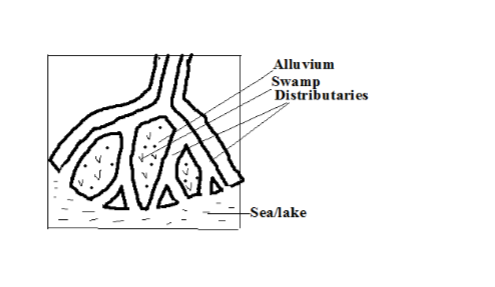
- Has many distributaries e.g. Tana and Rufiji deltas.
5. Birds Foot Delta

- Has few distributaries.
- Formed on a river carrying large quantities of fine alluvium into water where there is low wave energy e.g. Omo and Mississippi deltas.
6. Estuarine Delta
Formation
Development of a River Profile
- Longitudinal section of a river from source to mouth.
1. Youthful/ Torrent Stage
Characteristics
a) Steep gradient.
b) The river flows very fast.
c) Vertical erosion is dominant.
d) Headward erosion is evident.
Features
a) V- shaped valleys
b) Waterfalls
c) Rapids
d) Potholes
e) Gorges
f) Interlocking spurs.
2. Mature/ Valley Stage
Characteristics
a) Low and almost regular gradient.
b) The flow is less swift.
c) The river is wider due to being joined by tributaries.
d) Lateral and vertical erosion but lateral is more active.
e) Deposition starts at some sections.
Features
a) Wider open v-shaped valley
b) Meanders
c) River bluffs/cliffs
d) Slip off slopes
3. Old/ Plain Stage
Characteristics
a) Very gentle/almost level gradient.
b) Very slow flow of river.
c) The main work of the river is deposition.
d) Some lateral erosion occurs.
e) Seasonal floods are common.
Features
a) Shallow broad flat bottomed u-shaped valley.
b) Meanders
c) Oxbow lakes
d) Natural levees
e) Differed tributaries
f) Differed confluences
g) Braided channels
h) Flood plains
i) Deltas
j) Distributaries
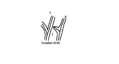
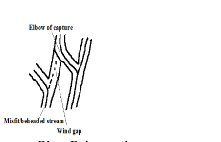
River Capture/Beheading/Piracy/Abstraction
- Diversion of head waters of one river into the system of an adjacent powerful river due to erosion.
The river that captures is called pirate.
The captured one is called victim.
How it occurs

The dry valley between the elbow of capture and the new course of the misfit stream is called a wind gap.
- Renewal of erosive activity of a river.
- Happens in the old stage.
Causes
A. Change in the Base Level
Base level is the lowest level to which a river can erode its bed.
Rejuvenation resulting is called dynamic rejuvenation
1. Drop in sea level
2. Uplift of a section of land along the rivers course.
3. Unequal sinking of land along a rivers course.
B. Increase in Rivers Discharge
Rejuvenation resulting is called static rejuvenation
C. Change in Rock Structure
Features of River Rejuvenation
1. Knick Points
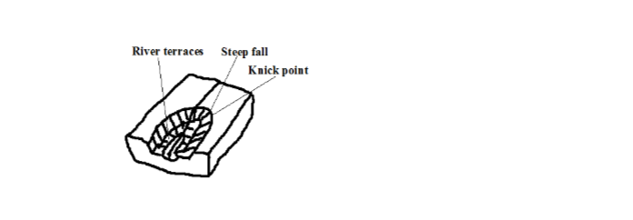
2. River Terraces
- Step like features formed when a river rejuvenates and cuts a new valley through the flood plain causing a plat form will form where the floor of the former flood plain was.
3. Water Falls
- Are formed when knick points are deepened e.g. Charlotte falls in Sierra Leone.
4. Antecedent Gorges
- Gorges which form where a river undercuts though a section of land that is being uplifted e.g. Turkwel gorge.
5. Incised Meanders
- Meanders that have been cut deeper into by a rejuvenated river.
Types
a) Entrenched Meanders
b) Ingrown Meanders
- Formed by lateral and vertical erosion causing one valley side to be steeper than the other and hence asymmetrical in cross section.

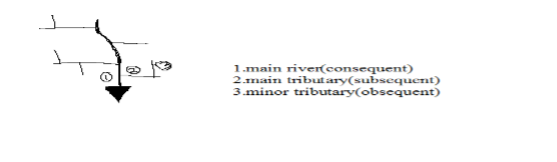
Drainage Systems
- Main river together with its tributaries.
Types 1. Accordant Drainage System
- Drainage system in which a river flows according to slope and rock structure by following areas of weak lines.
2. Discordant Drainage System
- Drainage systems in which rivers don’t flow in accordance with the slope, rock structure and land forming processes.
Types
a) Antecedent Drainage System

b) Superimposed Drainage System
- Drainage system which develops where a river maintains its flow over a new set of rocks after removing a former set of rocks.
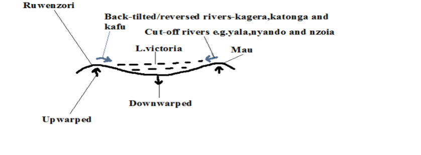
3. Back Tilted/Reversed Drainage System
- Drainage system where direction of flow is reversed be due to capture, uplifting or down warping e.g. R. Kagera, Katonga and Kafu.
Significance of Rivers and Their Features Positive
a) Rivers are sources of water for domestic and industrial use.
b) Rivers water is used for irrigation.
c) They provide port facilities where they have rias and estuaries.
d) Some rivers are used for transportation e.g. R. Congo and Nile.
e) Some rivers are fishing grounds e.g. Tana.
f) Rivers are dammed and used for H.E.P generation.
g) Features formed by river action such as waterfalls, gorges and oxbow lakes are a tourist attraction.
Negative
a) Rivers flood causing loss of life and property.
b) Rivers may lead to drowning accidents especially when they are flooded.
c) River water can be a medium of spreading diseases such as bilhazia and malaria.
d) Some wide rivers are barriers to transport and communication.
e) Some rivers also harbour dangerous wild animals which can kill humans e.g. crocodiles, hippos and snakes.
Lakes
A lake is a depression on the earth’s surface where water has accumulated.
Classification /Types of Lakes
According To the Nature of Water
a) Fresh water lakes which contain fresh water.
b) Salty lakes which have salty water.
According To the Mode of Formation of Depression They Occupy
1. by Earth or Tectonic Movements
a) Faulted or Rift Valley Lakes
b) Down Warped and Tilted Lakes
- L.Victoria is the second largest fresh water lake after L.Superior.
- Has a maximum depth of 87m deep. Other examples of lakes are L. Kyoga and Wamala.
Playas/sebkha is a lake contained in an inland drainage basin in a desert formed when rain or flood water flows into a basin formed by crustal warping e.g. Chemchane Sebkha in Mauritania.
2. by Vulcanicity
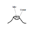
i) Crater Lakes
- Lake formed by water accumulating into a crater.
- Are usually salty.
- A crater lake formed on an explosion crater is called maar.
- Examples are Lakes Mossoko in Tanzania, Paradise in Marsabit and Myungu in Uganda.
3. by Erosion
a) Glacial Erosion
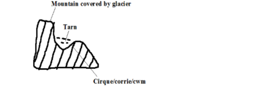
(i) Corrie/Tarn Lakes
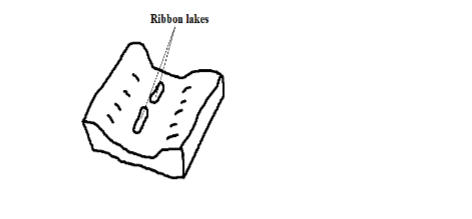
(ii) Ribbon Lakes
- Finger like on a glaciated valley.
- Lakes formed when ground water accumulates in a depression formed by wind deflation and abrasion.
c) Solution Lakes
- Lakes formed when rain or ground water accumulates in depressions formed in limestone rocks when rain water containing a weak carbonic acid dissolves limestone rocks e.g. Lakes Barber in Morrocco and Ojikoto in Namibia.
4. by Deposition
a) River Deposition
- Formed when river deposition occur cutting off a section of a pronounced meander e.g. oxbow lakes Shakababo and Mukunguya at lower part of Tana.
b) Wave Deposition
5. by Man
a) Dams are Lakes formed when water accumulates behind dams constructed across rivers resulting into a large man made reservoir called man made lake e.g. behind Seven Forks Dam and Lakes Volta in Ghana and Nasser in Egypt.
b) Barrage is a bank of earth or stones built across a river to provide water for farming.
Significance of Lakes
Positive
1. Fresh water lakes provide water for domestic and industrial use.
2. Fresh water lakes also provide water for irrigation e.g. Naivasha for horticultural farms around it.
3. Man made lakes and some other lakes e.g. Victoria (Owen falls) are used for generation of H.E.P.
4. Lakes are used for transport.
5. Some lakes contain valuable minerals e.g. trona at L. Magadi and salt at L. Katwe in Uganda.
6. Many lakes have fish which is a source of food and employment to fishermen and traders.
7. Lakes are also a tourist attraction by providing recreational facilities and being habitats for wildlife.
8. Some lakes are sources of rivers e.g. Victoria for White Nile and L.Tana for Blue Nile.
9. Lakes modify the climate of surrounding areas by sea breezes and convectional rainfall.
Negative
1. Lakes are habitats for disease vectors e.g. mosquitoes and snails which transmit Malaria and bilhazia.
2. Lakes may cause flooding due to excessive rainfall or when dams break leading to loss of life and property.
3. Lakes are habitats for dangerous animals like crocodiles, hippos and snakes which kill humans.
4. Lakes cause drowning accidents to people in time of storms.
Oceans, Seas and Their Coasts
An ocean is a large and extensive body of saline water occupying a basin between continents while a sea is a large body of saline water on the margins of continents.
Nature of Ocean Water
1. Ocean water is salty
- Due to abundant sodium chloride which rivers dissolved from land, from rocks that the water is in contact with and volcanic materials on the ocean floor?
- Ocean water has high salinity in areas where there is addition of little water and high rate of evaporation leading to high salt concentration e.g.
Dead Sea and lower where there is low temperatures and addition of fresh water from rivers, rain or snow melts e.g. Baltic Sea.
2. Surface water is warmer than that at the bottom except in Polar Regions where a thin layer of cold water may overlie warmer water.
3. Ocean water is a habitat for living organisms Planktons are plants and animals occupying ocean surface.
a) Phytoplankton are ocean plants e.g. algae.
b) Zooplankton are ocean animals e.g. lobsters, jelly fish, crabs, etc.
Types
i) Nektons are all forms of fish.
ii) Benthos are ocean creatures which live only at the bottom of margins of continents where sunlight reaches Sea floor e.g. snails, starfish and sea anemones.
4. Ocean water is polluted e.g. by industrial effluents, pesticides and herbicides carried by rivers and runoff to the sea.
5. Ocean topography is composed of several features
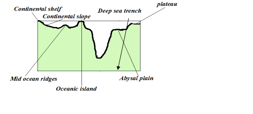
b) Continental slope - Steeply dipping surface between continental shelf and the ocean basin proper.
c) Abbysal plain - Almost level area of the ocean where sediments are deposited.
d) Mid ocean ridges - Range of hills which are submerged formed by volcanic and seismic activities.
e) Sea Islands - pieces of land surrounded by water.
i) Continental islands- Ones rising from continental shelf.
ii) Oceanic islands-Ones which rise from the sea floor e.g. Canary and Cape Verde.
iii) Coral islands-Ones made of coral.
f) Deep sea trenches - narrow steep sided submarine valleys on the ocean floor.
g) Guyots - submerged atolls forming an under water mountain.
h) Sea mount - a volcano which doesn’t rise above the sea floor.
6. A portion of ocean water moves
There are two types of movements namely:
Vertical Movements
- Movement of ocean water from surface to bottom and vice versa.
How they occur
1. Cold polar water sinking before moving horizontally towards equator.
2. Ocean currents converge
3. When ocean water sinks at lower depths after ocean currents converge.
4. When ocean water rises to the surface in a process called upwelling.
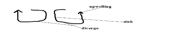
i) Carries nutrients for sea animals by upwelling.
ii) Oxygenation of water vital for fish survival.
Horizontal Movements
It occurs in the following ways:
1. Ocean Currents
An ocean current is a large mass of surface ocean water which is moving in a particular direction e.g.
Factors that influencing formation of ocean currents
a) Wind by blowing over water causing a mass of surface ocean water to move in its direction forming drift currents.
b) Rotation of the earth by causing deflection of ocean currents.
c) Shape of land mass by influencing current direction and causing it to flow following the coastal outline.
d) Differences in temperature by causing cold polar water which is dense due to low temp moves towards the equator passing on the ocean floor and warm water of the tropics to move towards the poles passing on the surface.
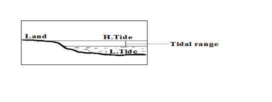
2. Tides
- Periodic rise and fall in the level of ocean and other large water bodies.
- Occurs when the moon and to some e the sun exert gravitational pull on the water bodies on the earth.
Rotation of the Earth
- It brings any longitude under the influence of 2 high and 2low tides in a lunar day.
- Similar tides occur at an interval of 12hrs 26 minutes.
- A lunar day is time taken by the earth to complete one rotation with respect to the moon (24 hrs 52 min)
- Lunar month is time taken by the moon to complete one revolution around the earth (27.3 days)
- The moon is always ahead of the earth by 52 minutes due to its revolution e.g. if Nairobi is opposite the moon at 6pm the following day the high tide will be at 6.52pm.
Types of tides
- Caused by relative positions of the moon and the sun from the earth.
- Sometimes the moon and the earth are nearer or farther from each other due to their elliptical orbits.
a) Spring Tides

- Occurs when the sun, moon and the earth are in a line (syzygy position) and pulling in the same plane causing pulling force to be greatest.
b) Neap Tides
- In which high tide is lower than normal and low tide is higher than normal.
- Occurs when the sun, moon and earth form a right angle and pulling water to themselves.
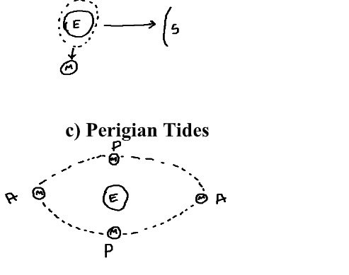
- Occur when the moon is nearest to the earth (perigee position) causing pulling force to be greatest.
d) Apogean Tides
- In which tidal range is lower than normal.
- Occur when moon is farthest from the earth (apogee position) causing pulling force to be weakest.
e) Diurnal Tides
- 1H1L in a lunar day
f) Semi Diurnal Tides - 2H2L in a lunar day which may rise or drop at the same level.
- Occur in most of Pacific Ocean.
g) Mixed Tides
- 2H2L in a lunar day where one pair may fluctuate in level while the other remains constant.
3. Waves
- A wave is a moving ridge of water on the sea.
- It’s formed when wind blows over an open water body causing oscillation of water particles.
Parts of a wave
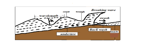
Trough - the bottom of a wave.
Wavelength - horizontal distance between two successive crests.
Height - difference in height between crest and trough.
Types of waves
a) Constructive Waves
- Waves in which swash is stronger than backwash resulting in deposition.
b) Destructive Waves
- Waves in which swash is weaker than backwash resulting in erosion.
Wave Erosion
Processes of Wave Erosion
a) Abrasion
- Scratching of ocean floor by materials carried by the back wash.
a) / Corrasion
- Hurling of pebbles and rock fragments against the rocks causing some particles to break off.
c) Attrition
- Rock fragments dragged up and down by the swash and backwash hitting against each other becoming smaller in size.
It provides tools for abrasion and corrosion.
d) Hydraulic Action
- Removal of materials from the coast by action of the force of moving water.
i) Direct wave force
- Large amounts of wave water crush against a rock face weakening and eventually breaking of the rock.
ii) Compressed air action
a) Waves crush against a rock.
b) The force of water pushes air into cracks compressing it and exerting pressure causing them to widen.
c) Wave retreats causing trapped air to expand resulting in sudden pressure release causing cracks to expand further.
d) The process is repeated several times causing the rocks to shatter.
e) Solution
- Some soluble minerals in rocks dissolve directly in water and are carried away in solution leaving cavities in rocks.
f) Corrosion
- Some minerals such as limestone reacting with sea water which has dissolved carbonic acid.
Factors influencing wave erosion
a) Waves must have strong backwash and a weak swash
b) Slope -The coast that slopes steeply into the sea favours erosion.
c) Load-large amount provides more abrasive tools. Angular shaped load is more effective in abrasion.
d) Amount of water in a wave - the larger the amount the greater the hydraulic force.
Features Resulting From Wave Erosion
a) Cliff and Wave Cut Platform
Cliff – A steep rock face which borders the sea.
Wave Cut Platform - A fairly flat part of the shore formed when a cliff retreats inland.


b) Bays and Headlands

Headland - a piece of land jutting into the sea.
c) Caves, Blow Hole and Geos

Blow Hole/ Gloup - Vertical hole formed on the side of cliff bordering the land.
It’s called a blow hole because when the waves break water is forced out of the hole.
Geos - Narrow sea inlet formed when the roof of a cave between the blow hole and the sea collapses.
d) Natural Arch, stack and stump
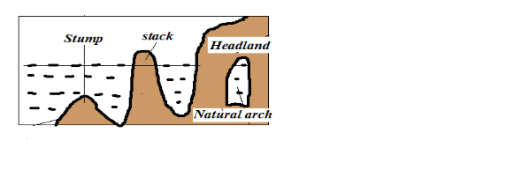
Stack - Pillar of rock left standing on the seaward side.
3 Stump
- The base of stack left when it collapses as a result of erosion at the base.
Wave Transportation
Types of load moved by waves are such as shingle, sand, mud and other objects dumped into the sea.
How the sea acquires its load
1. Materials brought by rivers and wind.
2. Products Þ@^ú rivweathering.
3. Materials brought by rivers and wind.
4. Debris from volcanic eruptions in the sea or on land bordering the sea.
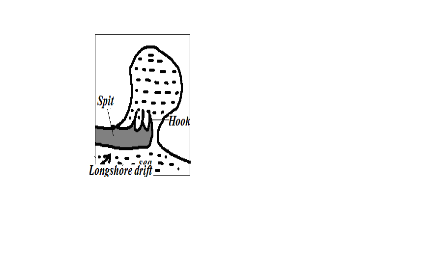
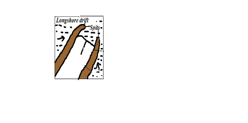
Waves transport load by a process called long shore drift.
Long shore drift is progressive dragging of materials along the beach as a result of waves breaking at an angle.
a) Strength of waves
Strong waves carry large quantities of load over a long distance while weak waves carry small quantities of load over a short distance.
b) Tides
Tides cause waves to break farther inland causing materials that were not in contact with breaking waves to be moved about.
c) Ocean currents
Ocean currents cause movement of materials from one part of the ocean to another e.g. coconut fruits from southern part of Africa to Gulf of Guinea by Benguela current.
d) Gradient of the shore
On gentle coasts transportation of materials is favoured by long shore drift while on a steep coast they bounce off cliffs and remain floating.
e) Orientation of coast line.
Transportation by long shore drift is favoured where coast is aligned obliquely to the direction of breaking waves while on transversely aligned coast swash moves materials back and fourth along the same line.
f) Nature of the load.
Lighter materials such as sand are carried over long distances while heavy load is transported over a short distance.
Deposition
- Process in which materials transported by waves are laid down on the shore.
Factors Influencing Wave Deposition
a) Load
b) Waves
Waves must have a strong swash and a weak backwash in order to cause excess load to be left behind on the shore.
c) gradient of the shore
The coast must be sloping to reduce the velocity and hence the energy of waves so that depositing occurs.
d) Depth of Water
Deposition takes place where water is shallow for waves to come into contact with ocean floor and break the cyclic motion of water.
Features Resulting From Wave Deposition
a) Beaches
- Gently sloping mass of accumulated materials such as sand, shingle and pebbles along the coast.
During storms destructive waves destroy beaches creating other minor features such as:
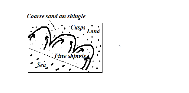
i) Beach cusps
ii) Beach Ridges and Beach Berms
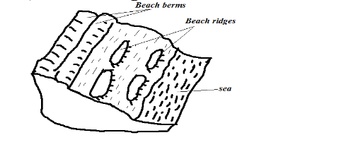
iii) Beach Berms
- Narrow terrace of shingle thrown up the beach by storm waves formed where tidal range is high.
iv) Beach Rock Shells
Masses of sand, shells and pebbles cemented together by calcium carbonate forming projections above the beach.
b) Spits
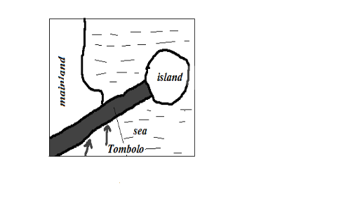
c) Tombolo
- Spit that grows out from the coast into the sea and joins an island e.g. Ras Hafur in Somalia and Ngomeni on Kenyan coast.
- Ridge of sand, shingles and mud which lies almost parallel to the coast.
Types
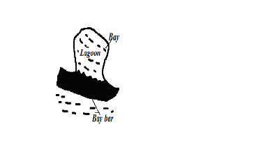
i) Bay bar – Bar which forms across the entrance of a bay.
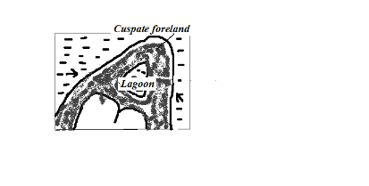
e) Cuspate foreland
- Broad triangular shaped deposits of sand or shingle projecting from the mainland into the sea.
f) Dune Belts

g) Mud Flats and Salt Marshes
Mudflats - Platform of mud consisting of fine silt and alluvium deposited in sea inlets such as bays and river estuaries.
Salt marshes - Vegetation such as grasses and mangrove that grows on a mudflat
Factors Determining the Type of Coasts
a) Wave action
Wave erosion makes a coast to have erosion features while deposition causes depositional features.
b) Tidal currents
Where tidal range is high more surface area is exposed to wave action.
c) Nature of rocks
Weak rocks are eroded to form bays (inlets) while resistant ones are left standing to form headlands.
d) Alignment of coast
There is more erosion on exposed coasts while deposition occurs where the coast is obliquely aligned to the breaking waves.
e) Change in sea level
Fall in sea level leads to emergence and rise to submergence.
Types of Coasts
According To the Alignment of Coast
1. discordant/transverse/irregular coast
- Coast which lies transversely to the coast line.
- Has a large number of inlets and receives heavy rainfall because winds blow onshore e.g. Mombasa.
2. Concordant coasts/regular/longitudinal coasts
- One which lies almost parallel to the coastline.
- Almost straight and lacks inlets and receives little rainfall due to winds blowing offshore e.g. Lamu.
According To Features Present
1. Submerged Coasts
- Coasts where a part of coastal land lies under the sea.
Causes of submergence
a) Rise in sea level e.g. when large quantities of melt water were released to the sea causing its level to rise due to climate change at the end of ice age.
b) Sinking of coastal land and a part of the sea floor.
Types a) Submerged Highland Coasts
- Found where submergence occurs on a coast characterised by steep slopes.
- Characterised by drowned features.
i) Ria Coast
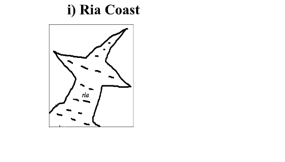
Characteristics
a) Funnel shaped
b) U-shaped in cross section.
c) Deeper and wider on the seaward side and shallower and narrower inland e.g. the Kenyan coast at Kilindini and Mtwapa.
ii) Fiord/Fjord coast
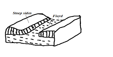
Characteristics
a) Deeper inland.
b) Shallower at the sea ward end due to terminal moraine deposited when glacier was melting.
iii) Longitudinal/Dalmatian Coasts
- Coast where ridges and valleys lying parallel to the coast line are drowned.
- Valleys form inlets called sounds while ridges form islands.
b) Submerged Lowland Coasts
- Found where submergence occurs on a coast characterised by gentle slopes.
Types
i) Estuarine Coast
- Coast characterised by broad shallow estuaries and mud flats which are visible at low tide.
- Wider and shallower than rias e.g. coastlines of Guinea and Senegal.
ii) Fjard Coast
- Coast characterised by numerous inlets formed by submergence of glaciated rocky lowland coasts.
- Have numerous islands and are deeper than rias e.g. S.E. coast of Sweden.
2. Emerged Coasts
- Coast where part of seafloor has become permanently exposed.
Causes of Emergence
1. Decrease in sea level due to decline in the source of water e.g. waters being held up in a glacier instead of it flowing back as rivers to the ocean.
2. Uplift of the coastal land by faulting, folding or isostatic adjustment.
Types i) Emerged Highland Coasts
- Found where emergence occurs on a coast characterised by steep slopes.
- Characterised wave action features which are isolated on land e.g. raised beaches, raised cliffs, raised wave cut platforms and raised arches.
ii) Emerged Lowland Coasts
- Found where emergence occurs on a coast characterised by gentle slopes.
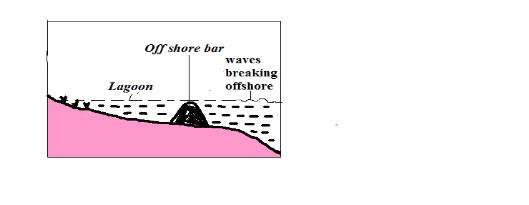
- Characterised by exposed depositional features e.g. spits and offshore bars which are found on land and a coastal plain formed as a result of a part of continental shelf becoming exposed.
3. Coral Coasts
- Coasts composed of coral rocks which are exoskeletons of marine organisms called coral polyps.
- They live in colonies/groups, feed on plankton and extract lime from the sea and build shells for protection.
Conditions Necessary for Coral Growth
a) warm water(25-29◦C)
b) Saline and clear water.
c) Sunlight should penetrate at least to a depth of 50m to allow plankton growth.
d) Plentiful supply of plankton which they feed on.
e) Shallow water.
Types of coral reefs i) Fringing Reefs

Characteristics
a) Flat or concave shaped
b) Higher on the seaward side
c) Outer edge falls steeply into the sea
ii) Barrier Reefs
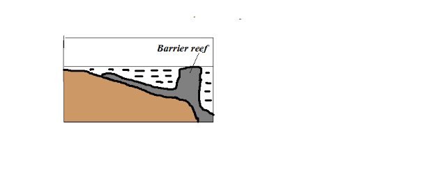
Characteristics
a) Its coral is joined to the shore.
b) Its outer edge falls steeply into the sea.
iii) Atoll Reef
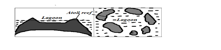
Characteristics
a) Circular in shape.
b) Encloses a fairly deep lagoon.
Theories of Formation
Darwin’s Theory
Murray’s Theory
Daly’s Theory
Significance of Oceans, Coasts and Coastal Features
Oceans
Positive
a) Influence climate by contributing the bulk of precipitation, warming effect in cool season and cooling effect in hot season by breezes and ocean currents.
b) Used for transport by means of boats, steamers and ferries.
c) Tourist attraction by being site for recreation e.g. swimming and sport fishing and marine life in parks such as in Mombasa and Lamu.
d) Oceans are a source of fish which is a source of food, income and employment.
e) Source of fresh water when its water is distilled.
f) Tropical seas have mangrove forests with mangrove trees which provide strong building and fencing posts and tannin for tanning leather and also habitat for marine life which is a tourist attraction.
g) Source of salt which crystallizes naturally after water evaporates in constricted bays in hot climates.
Negative
a) Tsunamis from oceans flood the neighbouring coastal areas causing great loss of life and property.
b) Oceans may also flood the neighbouring coastal areas as a result of rise in sea level caused by melting of glaciers caused by global warming.
c) Also harbour dangerous animals such as sharks and crocodiles which may attack and hurt or kill people.
d) Drowning accidents when there is breakdown of vessels or ship wrecking.
Coasts and Coastal Features
Positive
a) Fiords, rias and lagoons favour development of deep and well sheltered harbours.
b) Fiords are also a good breeding ground for fish as their shallow continental shelf encourage growth of plankton which is food for fish.
c) Coral rocks are used locally as building materials.
d) Coral rocks are also a source of coral limestone for cement manufacture.
e) Features such as coral reefs, caves, cliffs and fiords are a tourist attraction.
Negative
a) Some emerged coastal lands have infertile soils unsuitable for agriculture for being covered by sand, gravel and bare rock.
b) Deposited sands, bars and coral reefs are barrier to transport as they can cause ship wrecking if vessels hit them.
Action of Windand Water in Arid Areas
An arid area is a land which is deficient of moisture leading to scanty or no vegetation.
Action of Wind in Arid Areas
Wind Erosion
Physical weathering is the initial process then it’s followed by wind erosion.
Wind is more effective in tropical deserts due to:
a) Presence of loose unconsolidated dry masses of mud, sand and gravel.
b) Occurrence of strong tropical storms.
c) Absence of vegetation leading to high wind velocity due to little frictional force.
Factors influencing wind erosion
a) Wind speed- wind with high velocity has more energy to erode than with low velocity.
b) Load- angular shaped load provide more effective abrasive tools than one which is round shaped.
c) Nature of surface- Wind erosion is faster where the surface consists of unconsolidated materials.
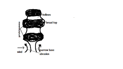
Processes/Ways in Which Wind Erodes Deserts a) Abrasion
- Materials carried by wind such as sand grains scratching rock surfaces across the path of wind.
- Greater close to the ground because it’s where heavy and more effective abrasion tools are lifted and carried.
b) Deflation
- Removal of unconsolidated materials such as sand and dust rolling and lifting or scooping and blowing away.
c) Attrition
- Sand grains carried by wind knocking against each other causing each other to become smaller and rounded in shape.
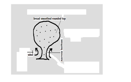
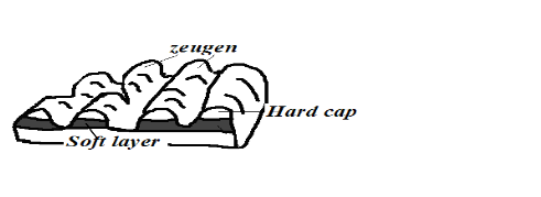
Resultant Features of Wind Erosion
a) Millet seeds

b) Ventifacts
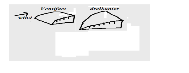
- Dreikanter - Ventifact with three wind faceted surfaces formed when wind is blowing in different directions.
c) Mushroom Block
d) Rock Pedestal
e) Deflation Hollows

f) Zeugen (Singular zeuge)
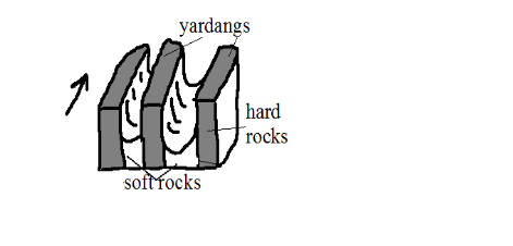
g) Yardangs
Wind Transportation
Factors Influencing Wind Transportation and Deposition
Wind velocity: when speed decreases strength also decreases and its ability to transport so wind starts to deposit materials.
a) Wind direction - Winds blowing from different direction converge and cause load to collide causing some of it to be deposited.
b) Nature of desert surface: - Wind transportation is more efficient on bare surfaces and hence less deposition there.
- Water surfaces such as oasis and moist surfaces impede transportation through friction causing wind to deposit materials.
- Less transportation on surfaces with vegetation as it reduces wind speed and also binds sand particles together.
c) Obstacles - Objects such as rock masses, land forms and vegetation block and reduce wind speed causing deposition.
d) Changes in weather conditions , such as sudden showers halts transportation and causes deposition by washing down suspended materials.
e) Load - Heavy load is deposited before light load when wind energy decreases.
When many materials are transported by wind they collide causing each other to be deposited.
Processes/ Ways in Which Wind Transports Load i) Suspension
- Wind lifting and holding particles such as dusts by air currents and transporting them over long distances.
ii) Saltation
- Wind transportation of heavy particles by a series of jumps and hops.
iii) Surface Creep
Resultant Features of Wind Deposition
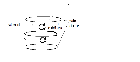
1. Sand Dunes
Dune - Low ridge of sand accumulated by wind deposition.
Types
i) Barchans
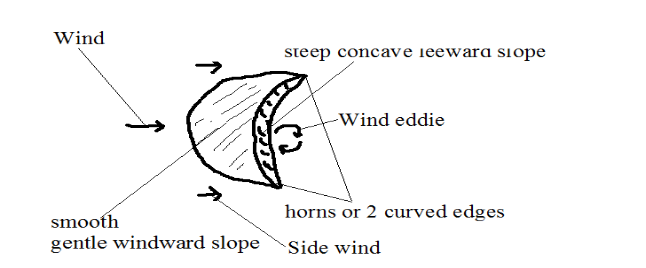
Characteristics
a) Crescent/moon shaped
b) Smooth gentle windward slope
c) Steep concave leeward slope
d) Horns or 2 curved edges
e) Occurs individually or in groups
ii) Seif Dunes
iii) Transverse/Wake Dunes

2. Drass
- Biggest sand features in a desert with surface resembling a plateau and with a height of up to 200m.
- Barchans and Seif dunes may form on such features e.g. in E. Sahara desert.
3. Loess
- Fertile soils with great thickness of about 100m formed from deposition of dust from deserts.
Action of water in arid areas
- Receives short occasional rains causing flash floods which erode transport and deposit large loads of materials produced by weathering.
- Water action is short lived.
Resultant Features of Water Action in Arid Areas
a) Wadis
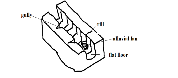
Characteristics
b) Dry River Valleys
c) Mesas and Buttes

Buttes - Smaller blocks of table like residual hills found in arid areas.
Features in an Inland Drainage Basin
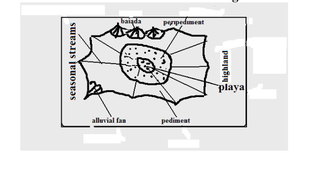
d) Playas/sebkha
- Extensive inland drainage basin in a desert formed by deflation or crustal warping or a small fluctuating salty lake contained in an inland drainage basin in a desert formed when water from torrential outpours flows into the basin by multiple temporary streams e.g. Chemchane sebkha in Mauritania.
e) Peripediment
Materials dry up leaving a hard salty crustal surface called Salina/salar e.g. in Arizona desert in U.S.A.
f) Pediment
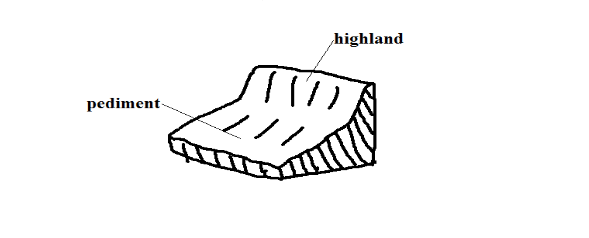
Low level plain formed when pediments are eroded to form a low level plain.
h) Pediplain

i) Inselbergs
- Prominent residual rocks in a desert.
- Formed by extension of pediments into upland areas.
Types
Bonhardt - Steep isolated round topped mass of rock rising steeply from desert surface.
Significance of Deserts and Desert Features
Positive
1. Loess soils are used for agriculture because they are very fertile e.g. in Huang He valley and Ukraine.
2. Loess soils in Europe and china have dug in caves which are inhabited during winter to provide warmth.
3. Desert features are a tourist attraction e.g. rock pedestals, Yardangs, Zeugen and sand dunes.
4. Oasis in deflation hollows are sources of water for domestic use.
5. Oasis water is also used for irrigation such as of date palms.
6. Deserts are good sites for testing military weapons, military training and experimenting ground for aircraft because they are sparsely populated.
7. The scarce vegetation in deserts such as shrubs can be used in livestock keeping e.g. goats, camels etc.
8. The hot sun in deserts can be harnessed to provide electricity for lighting, pumping of water, etc.
9. Seasonal streams can be dammed to supply water to surrounding areas e.g. Kigombo dam in Mbororo in Taita which supplies water to Voi town.
Negative
1. Some desert features can prevent physical development e.g. sand dunes can burry roads and it is difficult to construct bridges across wadis.
2. Sand dunes can cover oasis and settlements.
3. Sand dunes may destroy rich agricultural land.
4. High temperatures, shortage of water, unreliable rainfall and lack of transport and communication infrastructure discourage settlement.
Under/ground Water
- Water that exists beneath the earth’s surface in pore spaces in soil and rocks.
Sources of Ground Water
a) Rain Water
- Some rain water which percolates and is trapped after meeting an impermeable rock.
b) Melt Water
- Water that infiltrates into the ground when snow melts during spring and summer.
c) Surface Water
- Water from rivers, seas, swamps, oceans, lakes and ponds that seep into the ground.
d) Magmatic/Plutonic Water
- Water trapped in rocks beneath surface during vulcanicity
Factors Influencing Existence of Ground Water
a) Precipitation
- For ground water to exist precipitation must exceed evaporation.
- Light rain falling over a long period of time infiltrates more than heavy short lived downpour.
b) Slope
- On flat and gently sloping areas rain water has ample time to infiltrate because it remains in one place for a long time.
- On steep areas there is low infiltration since a lot of water turns into runoff because of getting less time to percolate.
c) Nature of Rocks
- There is a greater possibility of existence of ground water where there are permeable surface rocks.
- Ground water exists where impermeable rock overlie an impermeable one so that when water infiltrates and percolates underground it’s trapped by impermeable rock and accumulates above it.
Aquifer - permeable rock which is permanently saturated with water.
Permeable rocks - Rocks which allow water to pass through them.
Types
a) Porous - Those with pores/airspaces between rock grains through which water passes e.g. sandstone, limestone and chalk.
b) Pervious - Ones with cracks fractures and joints through which water enters and passes e.g. granite, limestone and chalk.
Impermeable rocks - Ones which don’t allow water to pass through them.
Types
a) Aquifuge - Impenetrable impermeable rocks e.g. gabbro, shale and slate.
b) Aquiclude - Porous rocks which absorb water and expand narrowing air spaces between grains preventing water to percolate downwards e.g. clay.
d) Vegetation Cover
- Plants break the speed of rain drops causing drops to hit the ground gently giving rain water ample time to percolate.
- On bare surfaces most of precipitation flows away as run off.
e) Level of Saturation of Ground
- Infiltration is more on dry ground because it has wide open air spaces while and less on a ground whose air spaces are saturated with water.
Water Table
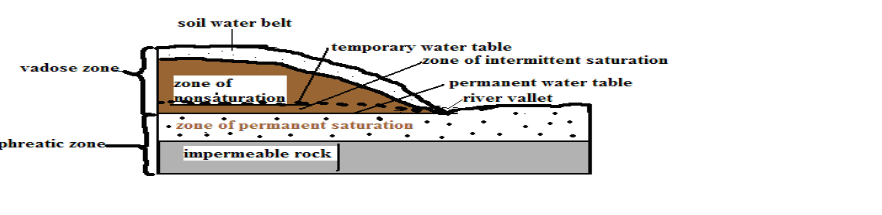
Zones of Saturation
a) Zone of Non-saturation
- Zone of permeable through which water passes but doesn’t remain in the pores for a long time.
- Well sunk to this zone doesn’t contain any water.
b) Zone of Intermittent Saturation
- Zone which during the rain season the rocks are saturated with water while during the dry season they are unsaturated.
Temporary water table - Upper level of ground water in the zone of intermittent saturation.
- Zone of non-saturation and that of intermittent saturation are called vadose zone.
c) Zone Of Permanent Saturation
- Zone where pores spaces are permanently filled with water.
Permanent water table - Upper level of ground water in the zone of permanent saturation.
Presence of ground water leads to formation of springs, wells boreholes and artesian basins.
Springs
Place where water flows out naturally onto the earth’s surface along a slope.
Ways/Modes Formation
a) Hillside Spring
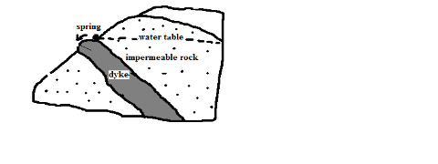
b) Dyke Spring
- Type formed where an igneous dike cuts across a layer of permeable rock.
c) Vauclusian Spring
- Type formed on a limestone hill or escarpment overlying an impermeable layer.
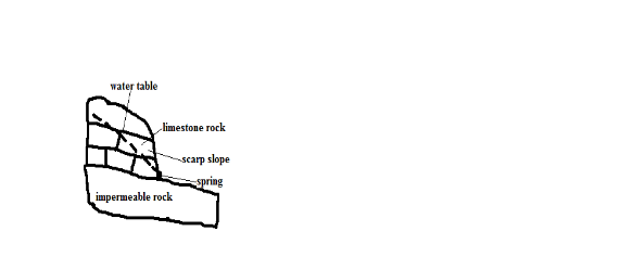
- Type formed where water table intersects the surface along the side of the valley.
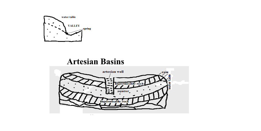
Characteristics
a) One or both ends are exposed on the surface on a rainy area or beneath a lake.
b) Water enters at the exposed end or ends.
c) With time the permeable rock is saturated with water and becomes an aquifer e.g. between Chad and Egypt across Quattara depression.
Artesian well
Well sunk into the aquifer of an artesian basin from which water will come out without being pumped.
Ideal Conditions for Formation of an Artesian Well
a) Aquifer to be sandwiched between impermeable rocks to prevent evaporation and percolation.
b) Aquifer to be exposed in a region which is a source of water e.g. rainy area or lake.
c) Aquifer to dip from the region of water intake.
d) Mouth of the well to be at a lower level than the intake area to develop hydraulic pressure which will force water out.
Problems Associated With Artesian Wells
a) Water may be hot due to high temperatures.
b) Water may be salty because of water taking long to percolate through rocks thus dissolving large quantities of mineral salts.
c) Water may fail to come out naturally when water is drawn faster than it’s being replaced in the source region and necessitating pumping.
Significance of Underground Water
1. Source of rivers and their tributaries.
2. Source of water for domestic and industrial use e.g. wells, springs, boreholes and oasis.
3. Used in agriculture e.g. oasis water is used for irrigation of date palms.
4. Influences settlements due to the availability of water e.g. in deserts people settle near oasis and spring line settlements in limestone areas.
5. Hot springs are a tourist attraction and their water is trapped and pumped into houses through pipes for heating during winter e.g. in Iceland.
6. Underground streams help in keeping some lakes fresh e.g. L. Naivasha.
Action of Water in Limestone Lime stone Areas (Karst Region)
Karst region - Region where the surface and the ground is covered with limestone rocks.
Karst scenery - Unique features in a Karst region resulting from the action of water e.g. Shimoni caves at the coast of Kenya.
- When calcium carbonate is exposed a weak carbonic acid formed by rain dissolving CO2 it’s dissolved to form calcium hydrogen carbonate which is removed from the rock in solution resulting in surface and underground features in such a limestone region.
Factors Influencing Development of Karst Scenery
a) Surface rock and the rock below should be hard and well jointed for acid water to percolate and cause solution to happen e.g. limestone, chalk or dolomite.
b) Climate should be hot to speed chemical weathering and humid for availability of rain which is a solvent.
c) Should have a lot of vegetation to release CO2.
d) Water table to be far below the surface so that the whole limestone rock is not dissolved and underground features fail to be formed.
Surface Features in Limestone Areas
a) Grikes and Clints
Clints - Blocks of limestone rock left standing when water infiltrates through the limestone rocks widening and deepening the joints.
Grikes - Deep groves or gullies formed when rainwater infiltrates through limestone rocks widening the joints by solution.
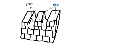
- Deep vertical holes formed on limestone rocks when solution extends the grikes.
- Referred to as swallow/sink holes because surface runoff or river water may disappear through them as a waterfall and come out of the ground as a vauclusian spring further downhill.
- Vertical shaft from the surface of the sink hole down into the ground is called ponor.
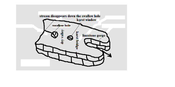
- Steep valleys with no permanent streams on limestone surface at the section between the swallow hole and where the river emerges.
d) Karst Window
- Small outlet to the surface from a cavern formed when continuous carbonation at the surface causes the roof of the cave to collapse.
e) Limestone Gorge
- Deep steep sided river valley in limestone rocks formed when the swallowed river causes solution to continue underground causing the roof of underground water course to collapse.
f) Karst Bridge
- Small section left joining the roof between the karst window and gorge.
g) Dolines
- Elliptical hollow with gently sloping sides on the surface of a limestone region formed when several swallow holes collapse and merge.
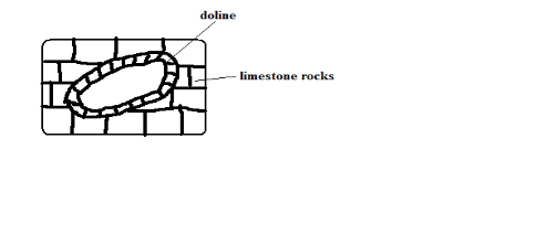
- Depression which may be as wide as 1 km in diameter formed on the surface of limestone regions when several dolines collapse and merge.

- Largest, shallow, elliptical and flat floored depressions on a limestone region formed when several uvalas collapse and merge.
- May become a temporary lake or may be covered by a marsh.
Underground Features in Limestone Areas
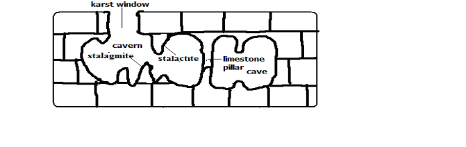
- Finger like masses of calcite hanging vertically from the roof of a limestone cave or cavern formed by repeated evaporation of water and giving off of carbon dioxide from drops of water containing calcium bicarbonate hanging from the roof of the cave causing crystallisation of calcium bicarbonate into calcite.
b) Stalactite
- Stumpy rock masses of calcite which grow from the floor of a limestone cave upwards formed by repeated dripping of solution of calcium bicarbonate from the end of stalactite to the floor of a limestone cave then it spreads out and crystallizes.
c) Limestone Pillars
- Pillar like structures in limestone caves formed when stalactites and stalagmites grow towards each other, stalagmite grows until it touches the roof of a cave or when a stalactite grows until it touches the floor of the cave.
d) Limestone caves
- Underground chambers or cavities in limestone rocks.
Significance of Karst Scenery
Positive
1. Features in karst scenery are a tourist attraction e.g. caves, gorges, stalactites, stalagmites, etc.
2. Limestone rock is used in the manufacture of cement e.g. cement factory at Bamburi in Mombasa and Athi River.
3. Limestone blocks are also used for building.
4. Limestone regions are very good for grazing particularly sheep because the surface is dry.
5. Large villages called spring line settlements form at the line of vauclusian springs due to the availability of water.
Negative
1. Limestone landscape discourages settlement because the surface is rocky, soils are thin and unsuitable for agriculture, surface is rugged with features like grikes and Clints and the water supply is inadequate due to rivers disappearing into swallow holes.
Glaciation
- Action of moving ice.
Glacier - Mass of ice moving outward from an area of accumulation.
- Formed when snow accumulates on the surface, lower layers are compressed to a harder mass resulting in opaque ice due to air bubbles and accumulation continues compression lower layers squeezing out air forming glassy ice called glacier.
Types
a) Cirque glacier - ice occupying a cirque
b) Valley glacier - Ice confined within a valley
c) Piedmont glacier- Glacier formed when valley glaciers converge at the foot of the mountain.
Ice bergs - Large mass of ice floating in the ocean formed when an ice sheet moves to the sea e.g. in Arctic and N. Atlantic Ocean.
Ice sheet - Continuous mass of ice covering a large area on the earth’s surface.
Ice caps - Ice covering the mountain peak.
Snow line - Line beyond which there is a permanent snow cover.
Ways of Ice Movement
a) Plastic Flowage
- Movement of ice like a viscous liquid.
b) Basal Slip
- Movement of ice by sliding over the underlying rock.
c) Extrusion Flow
- Movement of ice by spreading out.
d) Internal Shearing
- Breaking of ice into smaller pieces which move alongside one another.
Factors Influencing Ice Movement
a) Gradient of the Land
Ice moves faster on steep slopes than on gentle slopes due to the influence of gravity.
b) Season
Ice movement is faster in summer due to frequent thawing melting compared to winter when thawing is rare.
c) Friction
Central parts of ice move faster than sides and bottom which are in contact with rock beneath due to friction.
d) Thickness of Ice
Thicker masses of ice cause more pressure between them and rocks beneath which cause slight melting and therefore faster movement.
Glacial Erosion
Processes/Ways in Which Ice Erodes
a) Plucking
- Pulling away of parts of a rock at the base of glacier when the ice freezes into the cracks of a well jointed rock.
b) Abrasion
- Scratching of the underlying ground by stones and boulders carried by the ice as the glacier moves.
Factors Influencing Glacial Erosion
a) Nature of Underlying Rock
- Abrasion is more effective on soft rocks than hard rocks.
- Well jointed and faulted rocks are more eroded than those which are not because cracks and joints enable water to enter rocks and freeze which facilitates plucking.
b) Gradient of Slope
- Glacier on steep slopes moves faster and has greater kinetic energy to erode than slow moving glacier
c) Thickness of Ice
- Thick ice is heavier and exerts greater pressure on rock debris making them to abrade the underlying rock more effectively.
d) Availability of Debris
- The more the rock debris the more effective abrasion will be since it acts as abrasive tools.
- Too heavy debris makes erosion impossible since ice is not able to transport it but glides over it without acting on the rock below.
Erosion Features
On Glaciated Highlands
a) Cirque

b) Arêtes
- Narrow knife- edged steep ridge separating two cirques.
- Formed when two cirques cut backwards on adjacent sides of a mountain leaving a narrow steep ridge separating them.
c) Pyramidal Peaks
- Sharp steep sided peak at the top of a mountain.
- Formed when three or more cirques erode on mountain side towards each other leaving a sharp pointed rock separating them at the top of the mountain e.g. Corydon and Delamere on Mt. Kenya.
d) Glacial Trough
Glacial Trough and Related Features
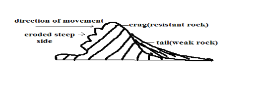
e) Truncated Spurs
- Interlocking spurs of former river valleys which are eroded and straightened by valley glacier.
Erosion Features on Glaciated Lowlands
a) Roche Mountonnee
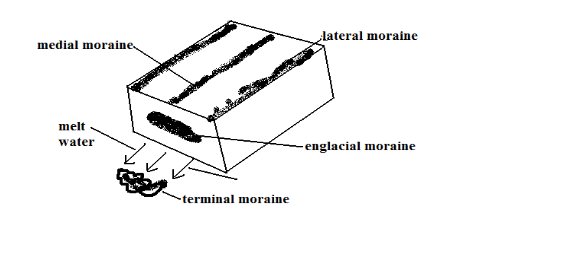
- Formed ice acts on a rock on its way causing the side facing the upstream side to be polished by abrasion resulting into a smooth gentle slope and the down stream side is affected by plucking resulting in a rugged steep slope leaving a rock outcrop standing just above the surface.
b) Crag and Tail
Crag - projection of resistant rock which protects a mass of softer rock on the downstream side of the glacier.
Tail - elongated feature on the downstream side of the crag formed by formed by material deposited by the glacier on the downstream side and the weaker rock.
c) Depressional Lakes
- Depressions filled with water from melting ice found in glaciated lowlands.
- Formed when soft rocks are scooped out by moving ice sheet forming depressions which are filled with water to form a lake.
Glacial Deposition
- Material carried by the glacier is called moraine.
Types of Moraine
a) Ground/sub-glacier moraine - load carried at the base of the glacier.
b) Englacial moraine - load within the glacier.
c) Lateral moraine - load carried at the sides of the glacier.
d) Medial moraine - load carried in the centre of the valley by glacier.
e) Terminal/recessional moraine - load deposited at the point where a glacier melts.
Types of Glacial Deposits/Drift:
a) Till - directly deposited by ice on melting in unstratified manner.
b) Fluvial - materials deposited by water from the melting ice in stratified manner.
Causes of Glacial Deposition
a) Amount of glacial drift
When ground moraine is too much the glacier glides over it leaving it behind.
b) Weight of glacier
When more ice is added to a stationary glacier pressure is exerted at the base causing melting and the material which was embedded in the ice is dropped.
c) Climatic change
During summer and spring ice melts depositing some materials the glacier was carrying.
d) Friction beneath the ice
Friction between ice and surface reduces ice speed causing heavy materials to be deposited beneath ice sheets.
e) Slope
Lowlands allow glacier to accumulate a lot of materials which are finally deposited by melting ice.
Features Resulting From Glacial Deposition
a) Till Plain

b) Erratics
- Large boulders of resistant rocks transported by glacier from highland and deposited on the till plain.
c) Drumlins

d) Terminal Moraine Ridge
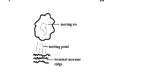
e) Eskers
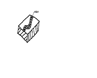
f) Kame

g) Kame Terrace
- Ridge of sand and gravel occurring in narrow lakes that exist between the glacier and an adjacent highland.
h) Outwash Plains

- Formed when finer materials of terminal moraine are deposited in very thick layers over an extensive area forming a plain.
Significance of Glaciation
Positive
1. Some outwash plains have fertile morainic soils suitable for agriculture e.g. Canadian prairies where wheat is grown.
2. Water falls on hanging valleys are used for generation of H.E.P.
3. Glaciated highlands are a tourist attraction especially during winter when sporting activities such as skiing and ice skating are carried out.
4. Glacial lakes such as great lakes of N.America provide natural route ways and fish sources e.g. L.Superior and Huron.
5. Glaciated mountains are catchment areas for permanent rivers.
6. Sheltered water of fiords is a suitable bleeding ground of fish as natural harbours.
7. Sand excavated from outwash plains and eskers is used for construction.
Negative
1. Land in glaciated areas can’t be fully utilised for agriculture due to being marshy because of boulder clay deposits e.g. central Ireland.
2. Infertile sands deposited in outwash plains make land unsuitable for agriculture.
3. Numerous lakes formed as a result of morainic deposits reduce the land available for agriculture.
4. Settlement and transportation in glaciated landscape is difficult due to ruggedness caused by glacial action.
Soil
- Uppermost layer of the earth’s crust on which plants grow.
Constituents/Composition of Soil
1. Inorganic Matter
- Weathered rock fragments made of minerals from parent rock.
- Forms skeleton or fabric of soil.
- Forms 45% of total volume.
2. Organic Matter
- Decomposed remains of animals and their wastes.
- Forms 5% of total volume.
Significance of Organic Matter
a) Broken down by bacteria forming humus improving the soil fertility.
b) Soil with high organic matter is alkaline while one with low organic matter is acidic.
3. Soil Water
- Water contained in the soil.
- Forms 25% of total volume.
Types of Soil Water
Hygroscopic Water
- Water held as a thin film around soil particles.
Gravitation Water
- Excess water which moves downwards to the zone of ground water.
Importance
a) Solvent of minerals and nutrients essential for plant growth.
b) Causes leaching Carrying of minerals.
c) Causes water logging which blocks air circulation causing soil to lack oxygen and become acidic.
4. Soil Air
- Air contained within air/pore spaces of soil.
- Forms 25% of total volume.
Importance
a) For plant and soil organisms metabolism.
b) For oxidation which causes conversion of part of organic material into nitrogen.
d) For respiration of aerobic micro-organisms which break down organic matter to form humus e.g. bacteria.
Soil Formation
Factors Influencing Soil Forming Processes
a) Parent Material
- Determines the type of soil, mineral composition and texture e.g. granite and sandstone weather to form sandy soils rich in quartz, volcanic lavas form clay soils with low quartz content and plants decompose to form loam rich in humus.
b) Climate
- Affect rate and type of weathering e.g. heavy rainfall results into deep soils due to heavy weathering and leaching.
- Wind in deserts causes formation of loess soils.
c) Living Organisms
- Micro-organisms such as bacteria cause plant and animal remains to decay into humus.
- Burrowing animals and worms mix organic remains with mineral soil component.
- Roots penetrate and add more porosity, improve soil depth and aeration.
d) Topography
- There is maximum soil development in rolling and well drained uplands where the rate of erosion matches that of soil erosion.
- Steep slopes result in shallow immature soils due to severe erosion.
Time
- The longer the time taken by soil forming processes the deeper and well developed soil is.
Soil Forming Processes
1. Weathering
- Breakdown of parent rock to form rock particles called regolith.
2. Decomposition of Organic Matter
Processes
a) Mineralization
- Biological and chemical breakdown of dead plant tissues by soil micro-organisms to simple soluble organic substances.
b) Humification
- Regrouping of mineralised dead plant material into large molecules to form humus.
3. Leaching
- Carrying of minerals from top layer down to the middle layer.
Types
i) Ferralisation/lateralisation
- Moving in solution or in suspension of weathered material from horizon “A” to “B.”
- Red soil form in horizon A as ferrisols/laterites (murrum).
ii) Illuviation
- Accumulation/redeposition of materials which had been leached to horizon B.
- Hard soil mass (hard pan) results.
iii) Eluviation
- Mechanical washing down of fine mineral particles in suspension from upper layer to lower layers by water which is percolating downwards. e.g. clay
iv) Podzolisation
- Heavy depletion of horizon A of all minerals especially bases and iron by soluble organic substances.
- Forms ash like soils which are acidic.
v) Calcification
- Limited leaching which allows redeposition of calcium compounds within the same soil profile.
vi) Ribification
- Dehydration of soils during dry season and leaching during the rainy season.
Properties and Characteristics of Soil
a) Texture
- Composition of soil in terms of its particles.
Importance
a) Determines soil water retention by that coarse grained soils have poor retention while those fine grained have high water retention.
b) Influences ease of root penetration into the soil whereby it is easy on coarse textured and difficult in fine textured.
c) Determining soil fertility in that clay content prevents humus from being washed down the soil by water.
b) Structure
- Arrangement of soil particles into aggregate compound particles.
Types
i) Crump soil structure - soil made of small, soft, groups of particles of irregular shape.
ii) Granular structure - soil made of porous groups of particles of irregular shape called granules.
iii) Plate structure - soil made of plate like flat particles arranged in horizontal manner.
iv) Prismatic structure - soil made of vertical prism like particles with rounded tops.
v) Blocky structure - soil made of irregular pieces of soil with sharp corners and edges.
c) Soil PH
- Basicity or acidity measure of a soil.
- Sulphate/phosphate - acidity
- Calcium/magnesium - Basicity
i) Influences the activity of soil micro-organisms and hence decomposition of organic matter.
ii) Influences rate at which roots absorb minerals.
iii) Determines the types of crops to be grown e.g. tea-acidic.
iv) Determines availability of different nutrients to the plants e.g. phosphorous is not available at low PH while potassium and iron not available at high PH.
d) Soil Colour
- Visible quality of soil.
Dark brown or black – considerable amount of organic matter.
Grey - poorly drained or water logged.
Whitish - lacks organic matter, iron oxides and has soluble salts concentration.
Importance
i) Influences soil temperature in that light coloured soils have low temperature and hence low organism activity.
ii) High temp destroy humus, increase organism activity and provide warmth required for germination.
e) Soil Porosity

Importance
i) Influence soil water retention. Clay has high retention and is water logged because it doesn’t allow drainage due to many tiny pore spaces while sand has poor water retention due to rapid percolation caused by large pore spaces.
f) Soil Permeability
- Ability to allow the water to pass through.
- Depends on texture and porosity.
Clay is impermeable due to being fine textured and tiny pored while sand is permeable due to being coarse textured and very porous.
Soil Profile
A mature soil is one with a fully developed profile while a young soil is one with a not fully developed profile.
Superficial layer
- Dry decaying organic matter covering the soil surface.
Horizon ‘A’
- Lies under a mat of surface vegetation and raw humus.
- Darker due to high humus content.
- Contains most of plant nutrients.
- Where most plant roots are found.
- Contains active micro organisms which breakdown organic matter into humus.
Horizon ‘B’
- Lies below top soil.
- Has small spaces between particles and hence less aerated.
- Has a hardpan or layer impeding drainage.
- Where most materials washed from horizon A have accumulated.
Horizon ‘C’
- Lies below sub soil.
- Made of partly mechanically weathered rock.
- Product of bed rock or may have been transported.
Horizon ‘D’
- Solid underlying rock.
- May have ponds of water which can be used by deep rooted plants during dry season.
Importance of Soil Profile
a) Determines the crops to be planted i.e. mature soils favour deep rooted crops while young soils favour shallow rooted crops.
b) Bed rock determines the chemical properties of the soil such as PH and nutrients.
Soil Catena
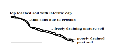
Factors Influencing Development of a Soil Catena
a) Relief
- On steep slopes there is high rate of erosion resulting in thin soils while on gentle slopes rate of weathering and erosion is balanced resulting in thick soils.
- On flat areas such as valley floors where there is deposition there are peat or alluvial soils.
b) Drainage
- First drainage at mountain tops results in thin stony immature soils.
- Poor drainage in flat areas results in peat or alluvial soils.
c) Transportation of Debris
- Surface runoff transports sediments to lower gentle slopes where it accumulates forming deep colluvial soils while thin stony immature soils with little organic matter called xeromorphic soils are left on steep slopes.
Soil Degeneration
- Decline in the usefulness of a soil.
Types 1. Physical Degeneration
- Decline in usefulness of a soil in which texture, structure, moisture and quality of soil are affected.
Causes
a) Deforestation which leads to removal of vegetation which forms a protective cover of the soil exposing it to erosion agents.
b) Overgrazing which causes excessive loss of water from the soil causing it to become loose and fine grained and easily eroded.
c) Poor Cultivation Techniques
i) Pulling hoe along the surface when removing weeds which loosens the soil and when it rains it’s washed away.
ii) Ploughing of land down slope which accelerates soil erosion.
iii) Cultivation of steep slopes and along river banks which encourages soil erosion.
iv) Burning which destroys vegetation covering the soil exposing it to erosion agents.
v) Growing crops on the same peace of land from season to season which sucks nutrients from the soil making it fine, loose and easy to be eroded.
vi) Planting crops such as maize whose foliage doesn’t provide adequate soil cover encourages soil erosion.
vii) Cultivation in areas that suffer prolonged droughts which loosen the soil causing it to be exposed to erosion during dry seasons.
d) Heavy rain resulting to excessive soil erosion and thus poorly aerated.
e) Drought which deprives the soil of moisture which holds the soil together causing particles to loosen making it to be easily brown by wind.
f) Excavation works such as quarrying, open-cast mining, building of estates and road construction which loosen and expose the soil to erosion agents.
g) Soil erosion which robs the soil of top fertile layer.
2. Chemical Degeneration
- Decline in usefulness due to changes in mineral nutrients of the soil.
Causes
a) Leaching which makes minerals inaccessible to shallow rooted crops.
b) Excessive application of fertilizers which interferes with bacterial activity and causes the soil to become too acidic and unable to support a variety of crops.
c) Excess water causing water logging causing acidic conditions.
d) Planting one type of crop repeatedly which makes the soil deficient of some nutrients.
e) Excessive drought which causes accumulation of salts in the top soil.
f) Burning such as in slash and burning which kills micro-organisms causing nitrogen deficiency when nitrogen fixing bacteria is killed.
3. Biological Degeneration
- Degeneration due to decline of organic content of the soil and organic matter.
a) Deforestation which deprives the soil of its organic content and moisture making it loose and more vulnerable to erosion.
b) Burning such as in slash and burning which kills micro-organisms causing low decomposition rate which robs soil of organic matter.
c) Overgrazing which causes removal of vegetation causing excessive loss of water from the soil and hence reduced micro-organism activity resulting into shortage of humus.
d) Drought and excessive moisture which may lead to a shortage of essential organisms such as bacteria, earthworms, termites and burrowing animals.
Soil Erosion
- Removal of top soil.
Agents of soil erosion are water, glacier and wind.
Causes of soil erosion are human activities and geomorphic processes such as earthquakes and faulting which cause land slides and soil creep.
Conditions Favouring Soil Erosion
a) Slope
- Steep slopes accelerate soil erosion while gentle slopes experience less erosion.
- Places with rugged terrain experience gulley erosion.
- Hilly and Steep areas experience rill and gulley erosion.
b) Soil Texture
- Areas with fine textured soils such as volcanic ash are more vulnerable to erosion e.g. Nyambene Hills around Karama and Muthara.
c) Climate
- Erratic and heavy rains cause splash, rill and sheet erosion.
- Intense heating by the sun causes loosening of soil particles.
- Low rainfall and high temperature leads to scanty or no vegetation which forms protective cover on the soil.
Types of Soil Erosion
a) Splash Erosion

b) Rill Erosion

- Occurs when rate of runoff exceeds infiltration and rain water flows over the surface forming small channels called rills.
c) Gulley Erosion
- Removal of soil through wide and deep channels.
- Occur when moving water or glacier widen and deepen the existing rills.

- Removal of top soil inform of a thin sheet.
- Common around L.Baringo and Marigat.
Impact/effect of Soil Erosion
Positive
a) Creation of rich agricultural lands when eroded soil is carried and deposited e.g. loess and alluvial soils in lower courses of R.Tana.
b) Sand eroded from steep slopes and deposited on river bed is scooped for construction purposes e.g. Machakos.
Negative
a) Lowers the agricultural productivity of land when fertile top soil is eroded.
b) Contributes to desertification when top soil is eroded leaving bare ground destroying vegetation.
c) Causes water pollution when agro-chemicals and other chemicals are carried to rivers, lakes or oceans.
d) Contributes to flooding by blocking river channels causing them to burst their banks during the rain season flooding the adjacent areas.
e) Causes siltation of water reservoirs reducing their utility e.g. For H.E.P. generation.
f) May cause collapsing of structures such as buildings and bridges when soil around them is eroded weakening their foundation.
Management and Conservation of Soil
Soil management is controlling processes and activities that would cause soil deterioration while soil conservation is protecting soil from destruction.
Soil Management and Conservation Measures
a) Crop Rotation
- Growing crops which require different nutrients on the same piece of land on rotational basis to prevents exhaustion of particular mineral nutrients from the soil e.g. leguminous plants to improve nitrogen content of the soil.
b) Mixed Farming
- Growing crops and keeping animals on the same farm.
- Manure from animals is used to enrich the soil with minerals and improve its structure.
c) Contour Ploughing
- Ploughing across the slope rather than down the slope.
- Helps to trap water on horizontal furrows thus preventing excessive soil removal.
d) Terracing
- Dividing the slope into a series of wide steps and crops are grown on them.
- Trap the soil from being carried away by running water and also traps water allowing it to gradually infiltrate into the soil.
e) Afforestation and Reafforestation
- Leaves reduce the force of rain drops preventing soil particles from being removed.
- Vegetation increases the rate of infiltration of rain water into the soil thus reducing runoff.
- Roots bind the soil particles together.
- Decayed vegetation provides humus which binds the soil particles together.
f) Planting Wind Breakers
- Planting hedges or trees around plots in large fields.
- Act as wind breakers and also trap soil being carried by water.
g) Regulating Livestock Numbers
- Matching the number of animals kept to the carrying capacity of land.
- Overgrazing can also be prevented by paddocking which ensures there is always pasture for animals and no area is overgrazed.
h) Constructing Gabions
- Construction of wire mesh boxes which are filled with soil.
- Allow water to pass through but trap the soil then vegetation gradually grows on the trapped soil.
i) Planting Cover Crops
- Planting crops which cover the soil properly and holds the soil in place e.g. sweet potato vines.
j) Mulching
- Covering the soil with crop residues.
- Reduces the impact of rain drops on the soil.
- Decays enriching soil with nutrients.
- Reduce the rate of moisture evaporation from the soil.
Significance of Soils
a) Gives physical support for the rooting system of plants and protects root system from damage.
b) Habitat for burrowing animals and bacteria necessary for breakdown of organic matter into humus.
c) Medium through which nutrients and air are made available to plants.
d) Provides mineral elements to plants e.g. nitrogen, calcium, phosphates, etc.
e) Is used in building and construction e.g. clay for making bricks and tiles.
f) Clay soil is used in ceramics such as making pots.
g) Some soils are used for decorative purpose e.g. ache used among Maasai.
h) Source of minerals especially to expectant mothers.
i) Soil contains valuable mineral elements such as alluvial gold.
j) Soil supports plant life which is a source of food for people and animals especially herbivores.
k) Soils are used for medicinal purposes e.g. clay is mixed with some herbs for medical purpose in some communities.
Significance of Soil on Plant Growth
Characteristics and properties of a particular soil influences plant growth and distribution.
PH
- High PH values favours growth of particular crops e.g. tea requires fairly acidic soils.
Drainage
- Water logged soils allow growth of particular plants like papyrus, tree swamps and mangrove on poorly drained saline soils.
Depth
- Deep soils support deep rooted plants e.g. large trees while shallow soils favour shallow rooted plants with spreading root system e.g. grasses.
Moisture content - Soils deficient of moisture support drought resistant plants.
Temperature
- There are stunted plants on cold soils and heath and moors on upper levels of mountains.
Aeration
- Poor aeration retards the growth of plants and impairs the roots ability to absorb water and nutrients.
Mineral composition
- Mineral deficiency in the soil causes retardation.
Soil Classification
- Grouping of soil according to specific properties such as age, texture, colour and climate.
1. Zonal Order
Mature soils with a well developed profile due to having undergone long time soil formation processes under good drainage conditions.
Sub-orders
a) Podsols
- Infertile and acidic soils which are heavily leached with base compounds like calcium removed leaving aluminium and iron compounds
- Found in forested areas and higher latitudes e.g. Scandinavian countries and Canadian Shield.
b) Podzolic Soils
- Soils similar with Podsols but found in areas with deciduous forests and hot climates e.g. Congo Basin and Kenya highlands.
c) Tundra Soils
- Soils with excessive moisture due to low evaporation rate causing permanent freezing of the soil.
- Associated with tundra climate e.g. Iceland and northern edge of Europe and Asia.
d) Latosols
- Soils with low organic content and high titanium salts content which form in conditions of high rainfall and temperatures.
- Crumbles into dust if ploughed during dry season and cracks if not ploughed.
- Found in volcanic areas e.g. Uasin Gishu and Laikipia plateau.
e) Nitosols
- Deep porous friable red soils known as Kikuyu red loam in Kenya.
- Well aerated and high capacity for moisture storage.
- Higher fertility and can support a variety of cash and food crops.
f) Phenozems (Prairie Soils) - Dark brown and generally fertile soils.
- Suitable for growing of cereals e.g. wheat.
- Common in Prairie Provinces of Canada, Narok and Athi-Kapiti plains.
g) Sierozems (desert soils)
- Soils found in desert conditions with little seasonal rainfall and high temperature.
- Relatively little humus due to sparse vegetation.
- Plenty of calcium carbonate inform of lime crust deposited on surface due to excessive evaporation.
h) Pedocals
- Dark soils which have had little leaching and rich in calcium carbonate.
- Common in semi-arid and sub-humid grasslands.
Sub-groups existing in Kenya i) Chermozems
- Dark coloured soils with relatively high organic matter from grass vegetation and a calcareous sub-soil.
- Conducive for cereal crop cultivation due to being found in rolling land and favourable climate for grass growth.
- Found at bottom lands around Nyambene Hills and N. grazing areas between Isiolo and Nyambene Hills.
ii) Vertisols/Black Cotton Soils
- Dark cracking clay soils.
- Poorly drained due to high clay content leading to poor permeability.
- Suitable for growing of rice, cotton and sun flower.
- Found in Mwea plains and Kano plains.
2. Intrazonal Order
- Soil formed under poor drainage conditions.
Sub-orders a) Hydromorphic soils
- Grey coloured soils formed in water logged areas.
Groups i) Plano soils - found on flat old land surfaces.
ii) Bog and meadow - found in meadows, marshes and swamps e.g. Lorian and Yala swamps.
b) Halmorphic Soils
- Soils formed under semi-arid and arid conditions through salinisation.
- Infertile and poorly drained.
- Found in Amboseli and N.E.Kenya.
c) Calcimorphic Soils
- Soils formed by calcification e.g. redzina soils which are shallow and rich in lime and humus on the upper profile developed under grass on limestone e.g. in England and steppes of Russia.
d) Andosols
- Dark brown volcanic ash soils formed from recent volcanic material.
- High silt content and very vulnerable to soil erosion.
- Found in Kenyan highlands and support extensive agricultural activities like coffee, tea, wheat and maize growing.
3. Azonal Order
- Soils without a well developed profile due to having not undergone full soil forming processes.
- Found on steep slopes and areas with poor drainage which don’t offer them time to mature.
Sub-orders
a) Lithosols
- Soils with thin stony soil which is shallow over bedrock without a definite “B” horizon.
b) Regosols
- Soils without genetic horizons which have developed from material deposits like alluvium.
- Common in hilly and mountainous areas of the world.
c) Alluvial Soils (Fluvisols)
- Soils developed from alluvium of recent origin.
- Common along river valleys and mouths like Tana.
d) Mountain Soils
- Shallow soils found in mountainous regions.
- Vulnerable to erosion on steep slopes.
e) Histosols
- Soils formed from accumulation of organic matter which is 20% of the soil composition.
- If drained can be used to grow truck crops like vegetables.
f) Arenosols
- Soils having the appearance of sand largely composed of sand.
- Less fertile due to low organic matter.
- Common in coastal areas and N.E. provinces.
Agriculture
- The practice of cultivating crops and rearing of animals
Factors Influencing Agriculture
1. Physical Factors
a) Climate
i) Temperature
- Some domestic animals do well in hot and warm areas e.g. goats and camels while others do well in cool areas e.g. exotic breeds of cattle such as Guernsey.
- Some crops do well in cool areas e.g. tea and wheat while some others do well in warm areas e.g. sisal and cotton.
- High temperatures increase the rate of evaporation of moisture which causes crops to wither and eventually die.
- Night frosts damage tender leaves of some crops e.g. tea and bananas.
ii) Sunshine
- Needed for photosynthesis process in which plants manufacture food for growth and formation of fruits and seeds.
- Sufficient sunshine is required during ripening of crops to ensure that they have high sugar content.
- Sunshine is required during harvesting to prevent crop from rotting and also for drying harvested crops.
iii) Winds
- Winds accelerate evaporation and transpiration which may cause crops to wither and eventually die.
- Hot and dry winds damage crops such as cocoa by causing them to ripen prematurely.
- Wind is important for pollination necessary for fruit and seed formation.
- Violent wind may cause falling of tall varieties of crops like maize and bananas.
iv) Moisture
- Inadequate moisture causes failed germination and retarded growth of crops.
- Too much water causes root and fruit rot.
- Livestock rearing is realised in areas which receive moderate to abundant rainfall - Insufficient rainfall leads to shortage of pasture for animals causing poor quality and low production
b) Soil
- Deep soils favour growth of deep rooted crops while shallow soils favour growth of shallow rooted crops.
- There is retarded growth of crops in infertile soils.
- Clay soils are suitable for growing of rice because they retain water for a long time.
- Volcanic soil favour growth of crops requiring acidic soils e.g. coffee and tea.
- Soil water is required for germination and facilitating uptake of minerals in solution.
c) Topography/relief i) Altitude
- Influences temperature determining type of crops and animals to be reared.
ii) Terrain
- Most crops do well on sloping land as it is well drained e.g. coffee and tea.
- Rolling plateaus and plains are suitable for large scale mechanized farming and irrigation.
- Gentle terrain eases cultivation and favours animals as they can graze with ease.
iii) Aspect
- Slopes facing the sun can support crop growing and livestock rearing because they are warmer while those facing away tend to be cooler and are dominated by forests and grasslands.
- Windward slopes are wetter than leeward slopes and more suitable for growing crops and rearing animals while leeward slopes are dominated by grasslands and more suitable for beef livestock rearing.
2. Biotic factors
a) Weeds
- Compete with plants for moisture, nutrients and sunlight leading to low and poor quality yields.
- Can choke pastures on which animals feed.
- Can increase the cost of agriculture as a lot of money is spent on hiring labour to weed the farms and buying chemical herbicides.
b) Insects
- Locusts and army warms eat green leaves and stems on their way destroying everything.
- Tsetse flies and ticks transmit livestock diseases i.e. trypanosomiasis and East Coast Fever.
- Some insects such as bees and butterflies are useful to crop farming because they aid in pollination.
- Bees give us honey.
- Controlling pests increases cost of agriculture.
c) Small Animals
- Squirrels eat newly planted maize.
- Rats and mice destroy harvested grains.
- Quelea birds feed on rice while on the farm reducing its yield.
d) Diseases
- Diseases weaken and eventually kill plants and animals.
- Diseases also weaken and kill humans which cause labour shortage increasing labour costs.
- Controlling diseases also increases cost of agriculture.
3. Human/ Social factors
a) Traditions
i) Gender
- In some communities, food production is a sole responsibility of women and children so the produce and land under cultivation will depend on women and children labour input e.g. W. Africa.
ii) Traditional foods
- Types of crops grown in most parts are traditional/staple foods of those communities.
iii) Prestige
- Maasai value cattle and whoever has the most cattle is regarded in high esteem.
b) Land Tenure System
- Cash crops such as coffee can’t be grown on leased land.
- Large scale farming can’t be practiced on excessively fragmented land.
- Nomadic pastoralism and shifting cultivation can be practiced in communally owned land.
c) Religious Beliefs
- Hindus don’t practise commercial cattle rearing because they treat cow as a sacred animal.
- Pig rearing isn’t practiced in regions with large presence of Muslims such as Arabic countries because Koran terms pig as unclean.
4. Economic Factors
a) Operating Costs
- If capital isn’t available he will farm on a smaller piece of land and vice versa.
- A farmer may decide not to grow a type of crop such as those easily perishable to avoid incurring cost in transporting and storing of produce to maintain their freshness.
b) Price Fluctuations
Price fall discourage some farmers causing some to neglect or uproot their crops and venture in other areas such as horticulture and dairy farming.
- When prices are favourable farmers may expand acreage under production.
c) Govt Policy/Political Factors
- Govt may encourage productivity by subsidies and guaranteeing prices.
- May tackle overproduction by withdrawing the same.
- May affecting acreage under particular types of crops e.g. by encouraging growing of cash crops or food crops.
Trade Restrictions
- Quota system ensures production doesn’t greatly exceed demand since a country won’t be able to export more quantity than it has been allocated.
Types of Agriculture
1. Arable Farming
- Cultivation and management of crops.
Types
a) Subsistence Arable farming
- Growing crops to provide for the farmer and his family.
Types i) Shifting Cultivation/Simple Subsistence Farming
- Farming in which a plot in a virgin forest is cultivated for 3-5 years after which its left fallow to regain fertility and a new section of forest is cultivated.
- Areas where it’s practiced - D.R.C, Zambia and Malaysia.
Method of Cultivation
a) A plot is sited in a virgin forest on well drained hill slopes.
b) Land is slashed and vegetation put on fire for ashes provide potash which improves fertility.
c) The land is dug using simple tools such as hoes or digging stick.
d) Staggered planting is done throughout the year to have a continuous supply of food.
e) The plot is cultivated for a period of 3-5yrs after which it’s abandoned and a new section of forest is cleared.
Characteristics
a) There is migration from one plot to another when the former plot loses fertility.
b) Cultivated areas are usually small (1-3 acres).
c) Very little attention is given to land and crops.
d) Short periods of crop occupancy alternate with long periods of fallowing.
e) Mainly uses manual labour provided by the immediate family.
f) Use of simple tools.
g) Crops are mainly starchy foods e.g. cassava, yams, millet, etc.
h) Land is cultivated by slash and burning.
Disadvantages
a) Exposes land to soil erosion on the plots which have been left fallow.
b) Doesn’t guarantee sufficient food production.
c) Extensive destruction of vegetation when fires get out of control.
d) Wasteful because sections of land stay fallow for a very long time.
e) Only practicable in areas with sparse population and plenty of land.
f) There are hardly any monetary gains because the produce is only enough for home consumption.
ii) Sedentary Subsistence Agriculture
- Farming in which the community permanently stays in one place.
- Areas where it’s practiced –tropical lowlands, C. America and S.E Asia.
Characteristics
a) The community occupies a permanent dwelling spot.
b) Fallowed fields are frequently reused.
c) Crop rotation is practiced in some areas.
d) More attention is given to the land and crops sown.
e) More labour is used in the field.
f) Can support a larger population compared to shifting cultivation.
iii) Intensive Subsistence Agriculture
- Farming which involves maximum utilization of all cultivable land.
- Carried out in areas experiencing population pressure so as to grow sufficient food to feed the population e.g. Japan, China, Srilanka, Pakistan, Kakamega, Nyeri, Kisii, etc.
Types
a) Dominated by other types of crops
b) Dominated by wet paddy
Characteristics
a) Very small plots resulting from years of fragmentation.
b) Intensive use of land.
c) Most work is carried out by hand.
d) Simple implements e.g. hoes, ploughs etc.
e) Several crops are grown on the same piece of land during the course of the year.
f) Crops vary from region to region e.g. Kenya - maize, beans, potatoes, Asia - rice in some areas, others-wheat, soya beans and barley.
g) Livestock rearing is almost nonexistent because there is no land for growing pasture.
h) Use of manure and chemical fertilizers to sustain high soil fertility for maximum yields.
i) Use of Irrigation to make up inadequacy of moisture.
b) Commercial Arable Farming
i) Plantation Agriculture
- Cultivation of cash crops on large tracts of land called estates or plantations.
Characteristics
a) Large tracts of land are cultivated.
b) Cash crops are grown e.g. coffee, tea, cocoa rubber, etc.
c) A single crop is usually grown.
d) Done for commercial purpose.
e) High capital is required to start and meet recurrent expenditure.
f) Crops take some years after planting before they start yielding.
g) Most plantations are owned by foreign companies.
h) Employment of scientific management to produce a lot of output.
Problems
a) Crops may be destroyed by climatic hazards reducing production.
b) High expenditure in maintaining plantations.
c) Subdivision of some plantations to provide land for the landless shareholders who bought them causing decline in output from plantations.
d) Crops may also be destroyed by insect pests and diseases which also affect labourers.
e) Rapid deterioration of soil due to monoculture, soil erosion due to complete weeding and most crops not providing sufficient soil cover.
f) Fluctuations of world prices causing the farmer to suffer great losses as they have no other crop to supplement their income.
g) Poor management whereby managers misuse funds and shareholders fight over management leaving plantations unattended.
ii) Extensive Mechanised Grain Cultivation
- Cultivation of grains on large tracts of land.
- Best developed in temperate grasslands of Prairies, Pampas, Veldt, and Downs which make the granary of the world.
- In Kenya it’s carried out in Uasin Gishu plateau, Nakuru and Narok.
Characteristics
a) Extremely large farms in mid-latitudes.
b) Cultivation is highly mechanized due to large farm sizes and its more economical and efficient.
c) Wheat is the main crop cultivated with other crops including barley, corn, millet and sorghum in Veldt etc.
d) Yield per farmer is high due to mechanisation.
e) Grain is raised on unirrigated land since it requires as little as 325mm annual precipitation.
f) Farms are individually owned.
iii) Intensive Commercial Agriculture
- Intensive use of land to produce maximum yield of crop per unit area for sale.
- Areas - N.W. Europe, E. U.S.A, former U.S.S.R and slopes of Mt. Kenya and Kilimanjaro.
Characteristics
a) Soil is utilised intensively to ensure maximum yields per unit area.
b) Farms are generally small in size.
c) Manual labour is used to tend crops.
d) Proper care is given to planted crops.
e) Mechanisation where farms are a bit larger.
f) Farmers use large amounts of fertilizers, hybrid seeds and pesticides.
g) Irrigation water is used to supplement rainfall insufficiency.
h) Farming is sometimes highly specialised with some farms growing crops or keeping animals.
c) Mediterranean Agriculture
- Type distinct to areas experiencing Mediterranean climate.
Main areas - middle Chile, Piedmont district in N. Italy and Andalistic District of S. Spain.
Characteristics
a) Farming is intensive.
b) It’s highly specialised.
c) Subsistence farming is practiced alongside commercial farming.
d) Cereal crops are most widespread e.g. barley and wheat.
e) Orchard farming is carried out and it’s the leading producer of citrus fruits, olives, dates and figs.
f) A small number of sheep, goats and cows are reared due to prolonged droughts and coarse bunchy grasses unsuitable for livestock.
Crop Farming
Cash crops are grown mainly in southern part of Kenya due to the following factors:
a) Suitable climatic conditions for a variety of crops such as temperature ranging from cool to cold, rainfall ranging between 800-2000mm annually and dry sunny periods between rainy seasons.
b) Fertile volcanic soils in highlands or alluvial soils in the lake basin of Kenya suitable for crop growing.
c) Adequate labour supply due to high population.
d) Long tradition of cash crops growing emanating from cash crops introduction by European settlers.
e) Govt policy to support small scale farmers
Some of the major cash crops grown in Kenya
a) Pyrethrum - Nakuru, Kisii, Limuru, Nyandarua.
b) Sisal -Thika, Taita-Taveta, Baringo, Kilifi.
c) Wattle - Uasin Gishu, Thika, Kiambu.
d) Cashew nuts - Kilifi.
e) Cotton-Rachuonyo, Busia, Meru, Kitui, Makueni.
f) Rice - Busia, Kirinyaga.
Tea Farming In Kenya
- Tea is a tropical plant with a botanical name Camellia Sinesis.
- First introduced in Limuru in 1903
Tea types
a) Aswan variety¬ common in India and Srilanka.
b) Chinese variety.
- Kenya is the largest producer in Africa, among top 6 world producers and has the best tea in the world market.
Major Growing Areas
W. Highlands – Kericho, Nandi, Kakamega, Cherangani hills.
E. Highlands – Nyeri, Murang`a, Kiambu, Thika, etc.
Conditions Necessary for Tea Growing
Physical Requirements
a) Warm temperature throughout the year (15◦C-30◦C).
b) Heavy and well distributed rainfall (1000-2000mm annually).
c) Deep and slightly acidic soils.
d) High altitude of about 1000-3000m above sea level.
e) The area to be free from frost.
f) Gently sloping land which is well drained.
g) Area to be shielded from strong sunlight and violent winds.
Human Requirements
a) Adequate labour for cultivation and processing which are labour intensive.
b) Good transport routes for quick transport of tea leaves to factory before they start withering.
c) Location of tea factories near farms for quick processing of tea as soon as possible.
d) Availability of capital to pay for the labour required in land preparation, planting, regular picking etc.
Tea Cultivation
Harvesting Of Tea
Processing Of Tea
Problems Facing Kenyan Tea Farmers
a) Pests e.g. weevils and beetles which attack tender leaves supposed to be picked.
b) Diseases e.g. root rot which causes the bush to wither, dry and eventually die.
c) Hail stones which fall on tea bushes causing damage e.g. in Kericho and Nandi.
d) Fluctuations of world prices which causes the farmers to lose morale and neglect or uproot the crop.
e) Shortage of rainfall leading to reduction in leaf production.
f) Transport problems in some areas due to dilapidated roads which cause spoilage of harvested tea before it reaches the factory.
g) Shortage of labour in some tea growing areas where young people have migrated to towns.
h) Shortage of capital to meet production costs.
Marketing of Tea in Kenya
- Some tea is consumed locally and a huge amount is sold on the international market.
- Major marketer is K.T.D.A.
Functions of KTDA
a) Collection of tea from buying centres.
b) Processing of tea.
c) Providing farmers with inputs such as fertiliser.
d) Sensitizes farmers on high quality production of tea.
e) Facilitates sale of tea at best possible prices.
f) Ensures prompt collection of payment from all tea buyers.
g) Promotion of tea with the aim of expanding market share.
Outlets through Which It Markets Tea
1. Factory door sale of tea in polythene bags to farmers accounting for 3% of sales.
2. Through Mombasa auction where its exported to other countries such as Britain, France Afghanistan. It accounts for 75% of sales.
3. Dealing directly with interested buyers which accounts for 15% of sales.
- KETEPA is the largest tea packing company in Africa belonging to tea grower’s grades, blends and packs some of the tea then sells to local market and exports superior qualities.
- Other companies which pack tea for local sale include Kikuyu Highland Tea Company and Unilever Kenya (Home Cup).
Significance of Tea Farming in Kenya
a) Earns foreign exchange from tea export.
b) Saves some foreign exchange that would be used to import tea.
c) Farmers earn income which raises their standard of living.
d) It creates employment such as for people working in farms and factories.
e) Has led to development of industries such as processing factories, blending and packaging industries.
f) Has led to development of infrastructure by roads being improved to ease transportation of tea to factories..
Sugar Cane Growing In Kenya
- Sugarcane is a coarse perennial grass belonging to sacharum family.
- It was introduced in Kenya in 1902 by an Australian farmer whereby commercial growing began in Miwani, Kibos and Ramisi.
Main Growing Areas
Nyanza: Muhoroni, Miwani, Chemilil and Awendo.
Coastal: Ramisi.
Western: Mumias, Nzoia, Kabras, Nambele.
Conditions Favouring Sugarcane growing (requirements)
Physical
a) High temperatures(21◦c-27◦C)
b) High and well distributed rainfall (1200-1500mm annually).
c) Dry and sunny weather during harvesting to increase sugar accumulation in the cane.
d) Fertile and well drained soils.
e) Undulating land for machinery to be used and for easier transportation of cane to factories.
f) Altitude between sea level and 1600m.
Human Requirements
a) Abundant labour for planting, weeding, cutting and loading onto trucks.
b) A good transport infrastructure for sugarcane to reach the factory within a week after harvesting.
c) Location of processing factories within the growing areas for quick processing of sugarcane before losing its sugar content through drying.
d) Availability of capital to pay workers in the field, buy farm machinery, etc.
Cultivation of Sugarcane
Harvesting of Sugarcane
Processing of Sugarcane
Uses of Sugar
a) In baking to sweeten bread, cakes, etc.
b) Sweetening foods and drinks e.g. porridge, chapati, tea, coffee, etc.
c) Making local brews e.g. Karubu, nguru, etc.
d) In soft drinks industries e.g. soda, juice, etc.
e) Making sweets and chocolates, etc.
f) Manufacture of drugs e.g. syrups and sugar coated tablets.
Uses of By-products
a) Molasses is used as a sweetener for livestock feeds.
b) It’s also used to manufacture ethanol, acetone and ethyl-acetate.
c) Bagasse or fibre left after squeezing the juice is used as fuel for boilers, for preparing pulp for making paper used for making cement and fertilizer bags and as fodder or manure.
d) Filter cake resulting from filtration process is used as manure for cane.
Marketing of Sugar
- Consumed locally.
- Factories sell to wholesalers and retail outlets to consumers.
Significance of Sugarcane growing
a) Creation of employment e.g. in estates, factories, sugar mills.
b) Promotes development of industries such as processing sugar cane, industrial spirit and breweries manufacturing, etc.
c) Has led to growth of towns in growing areas e.g. Muhoroni, Awendo and Mumias.
d) Saves some foreign exchange that would be used in sugar importation.
e) Farmers earn income through cane sale raising their standards of living.
f) Provision of social amenities to workers such as schools, houses and health centres to take care of workers welfare e.g. Mumias.
Problems Facing Sugarcane Farming In Kenya
a) Pests e.g. termites which attack setts lowering the farmers yield.
b) Diseases e.g. sugarcane mosaic which causes the crop to become stunted with leaves becoming yellow.
c) Mismanagement of some sugar factories resulting in their closure and subsequent loss of income and jobs.
d) Inability of some factories to cope with supply of cane from out-growers due to low production capacity and outdated technology.
e) Local sugar industry faces competition from cheap imported sugar from COMESA countries.
f) Strikes by cane farmers and transporters due to inadequate pay resulting in drop in output.
g) Frequent fires which destroy many hectares of cane annually.
Maize Farming in Kenya
- An annual crop of the grass family with a botanical name zea may.
- Brought by Portuguese traders to E. African coast in 18th century.
- Single most extensively grown crop.
Main Growing Areas
- Transnzoia, Nakuru, Bungoma and Uasin Gishu districts.
Conditions Favouring Maize Growing In Kenya
Physical Requirements
a) Warm temperatures (above 15◦c).
b) High annual rainfall(635-1145mm)
c) Deep well drained fertile soil with abundant amount of nitrogen.
d) Undulating landscape to allow use of machines.
e) Lower altitudes of about 1800m or below sea level.
Human Requirements
1. Abundant labour for preparation of land, sowing, weeding, shelling and packing.
2. A good transport network to enable farmers to transport harvested grain to millers and buying centres.
3. A good and sufficient storage facility for the grain after it has been harvested and before it is sold.
4. Availability of capital to pay for labour, buy inputs and pay for transportation of grain to the market.
Cultivation of Maize
Processing of Maize
Uses of Maize
a) Used as food for githeri and flour for ugali and porridge.
b) Grains are also used in the manufacture of animal feeds e.g. maize jam.
c) Tender maize plants are chopped and mixed with molasses to make silage for livestock.
d) Used to make salad oil for cooking, industrial alcohol and starch.
e) Stalks and cobs are used as organic manure and to provide domestic fuel.
Marketing of Maize
- Mainly sold by NCPB.
- Farmers also sell directly to consumers and millers.
Importance to Kenya’s Economy
a) Saves foreign exchange by avoiding importing maize all the time.
b) Promotes growth of industries where it’s used as raw material e.g. milling and corn oil industries.
c) Has created employment e.g. for farm workers, milling workers.
d) Provides income to farmers raising their standard of living.
e) Government earns revenue from taxes levied on maize products such as corn oil and alcohol.
Problems Facing Maize Farmers in Kenya
a) Pests such as stalk borers which penetrate to the centre of the plant.
b) Diseases such as white leaf blight which causes oval, grey lesions on the leaves.
c) Reduction of maize prices in the local market caused by irregular importation of maize which discourages the farmers.
d) Inadequate capital on the farmer part to buy inputs such as seeds, fertilizers and insect sides.
e) Soil exhaustion due prolonged planting of maize leading to poor yields.
f) Exploitation of farmers by middle men who buy their produce at throw away prices making the farmers unable to meet production costs.
Cocoa Growing In Ghana
- Cocoa originated from lowlands of C. America.
- Is grown in W. African countries such as Ghana, Nigeria, Cote d’ivoire and Cameroon.
- They account for nearly 3/4 of the world’s cocoa production.
- Ghana is the second leading producer after Cote d’ivoire.
Main Growing Areas
- Cocoa triangle formed by Accra, Kumasi and Takoradi.
Conditions Favouring Cocoa Growing in Ghana
Physical Factors
a) High temperatures of over 26◦c throughout the year.
b) High and well distributed rainfall (1300-1500mm annually).
c) Low altitude areas below 700m above sea level.
d) Slightly drier period during harvesting.
e) High relative humidity of over 75%.
f) Fertile well drained soils rich in iron and potassium.
g) Protection from sunshine which causes high rate of evaporation and winds which cause pods to fall off by inter-planting with shady trees such as bananas, oil palms and kola trees.
Human Factors
a) Abundant labour for cultivation, harvesting and processing.
b) Availability of market.
Cultivation of Cocoa
Uses of Cocoa
- Consumed as a beverage.
- Used to make cocoa butter, chocolates and drugs.
Significance of Cocoa to Ghana’s Economy
1. Earns Ghana a most foreign exchange (60%).
2. The foreign exchange from cocoa is used to improve infrastructure and social amenities.
3. A source of employment for over 20% of working population.
4. Provides a steady income for farmers which has improves their standard of living.
Problems Facing Cocoa Farming in Ghana
1. Pests e.g. capsid bug which sucks the pulp in pods and causes the tree to die.
2. Diseases e.g. black pod which affects the pods.
3. Fluctuations of cocoa prices in the world market causing the farmer and the country to receive low income.
4. Shortage of labour during harvesting season which causes delay in harvesting and high expenses when hiring labour from neighbouring countries.
Oil Palm Farming in Nigeria
- Oil Palm originated from W. Africa.
- Grows in bunches with each carrying up to 1000 egg shaped fruits which weigh 50 kg.
- Nigeria is the 2nd leading exporter of palm oil after Malaysia.
Main Growing Areas
- Forest belt around port Harcout where it’s grown on small farms and Sapele and Calabar where it’s grown in estates.
Conditions Favouring Oil Farming in Nigeria
Physical Factors
a) High temperatures throughout the year (over 21◦c).
b) Heavy and well distributed rainfall throughout the year.
c) High relative humidity.
d) Well drained porous and fertile soils.
e) Undulating land which is less exposed to strong winds.
Human Factors
a) Abundant labour for clearing land, tendering seedlings, regular weeding, etc.
b) Proper transport network for harvested fruits to reach the processing factories the same day so as not to change into fatty acids.
c) Location of processing factories within or near growing areas since oil palms are perishable and must be processed the same day.
d) Efficient management to ensure that the crops are inspected frequently for any disease or pest attack for spraying to be done to control their spread.
e) Capital to pay labour wages, maintain feeder roads, vehicles and factories.
Cultivation of Oil Palm
Harvesting of Oil Palm
- Harvested by cutting the base of the bunch using a curved knife tied on a long pole.
- The fruits are immediately collected and transported to the factory in lorries.
Processing/Extraction of Oil from Oil Palm Fruit
Traditional Technique
The method produces very little oil which lacks consistency in quality.
Use of Pioneer Mills
Uses of Palm Oil
a) Used domestically for cooking, lighting and polishing.
b) Used in the manufacture of cooking fats, soaps and candles.
c) Kernel is used to make expensive cooking oil, margarine, cosmetics and oil soaps.
d) Used as a cleaning agent in industries.
Uses of Palm Tree
a) Palm leaves are used for thatching, making mats, baskets and brooms.
b) Pericarp fibres and nut shells are used as fuel.
c) Palm trees are used as building poles.
d) The tree is tapped for its sap which is fermented to make palm wine.
Marketing of Oil Palm
- Most of palm oil and kernels are consumed locally and less than 50% is exported.
- Most of the kernels are exported to Britain, W. Europe and U.S.A.
Significance of Oil Palm to Nigeria’s Economy
a) It’s a source of foreign exchange.
b) It saves some of foreign exchange.
c) Provides employment to people as farm hands, processing, etc which raises their standard of living.
d) Has led to development of infrastructure to link processing areas with processing factories.
e) Promoted development of industries where it’s used as a raw material e.g. making cosmetics, toilet soaps etc.
f) Farmers earn regular income which raises their standard of living.
Problems Facing Oil Palm Farming in Nigeria
a) Pests and diseases which young plants due to their vulnerability which calls for regular spraying which is expensive.
b) Inadequate capital to purchase inputs leading to low yields.
c) Transport problems in some areas due to impassable roads leading to delays in delivering fruits to processing mills leading to low quality oil.
d) Government policy to encourage food production to reduce food importation which lowers oil palm production.
Coffee Farming in Kenya and Brazil
- Coffee tree originated from southern highlands of Ethiopia.
- Was introduced in Kenya by St. Austin’s missionaries in Nairobi via Kibwezi, Taita and Bura.
Growing Areas
a) Central Province - Nyeri, Muranga, Kiambu, Thika, Kirinyaga.
b) E. Province - Embu, Machakos, Tharaka, Makueni and high areas of Meru.
c) Coast Province - Taita Taveta in Wundanyi area.
d) W. Province - Bungoma, Vihiga, Kakamega.
e) Nyanza Province - Kisii, Nyamira, Nyabondo, Oyugis.
f) Nairobi Province - outskirts bordering Kiambu and Thika.
Factors Favouring Coffee Growing
Kenya
Physical Factors
a) High altitude (910-2100m).
b) Cool temperatures (14-26◦c).
c) High and well distributed rainfall (1000-2030mm) annually.
d) Deep and well drained acidic soils.
e) Undulating landscape to ensure good drainage and aeration.
Human Factors
a) Adequate supply of cheap labour for land preparation, planting, weeding, etc.
b) Good roads for transporting coffee to factories and to the markets.
Brazil
- She is the leading producer of coffee.
Physical Factors
1. Cool temperatures (14◦c-26◦c).
2. High rainfall of 1525mm.
3. A long dry season of up to 5 months to allow ripening and harvesting.
4. Terra Rosa soils which are deep, porous and rich in potash and humus.
5. Undulating surface at the Brazilian plateau around Sao Paolo.
Human Factors
a) Availability of cheap labour from tenant labourers given small plots to grow subsistence crops which makes production costs to be low.
b) A good transport infrastructure with roads and railways linking estates to export ports and cities like Sao Paolo, Salvador and Rio de Janeiro.
Methods of Coffee Production
Brazil
- Most of land is owned by rich land owners and a small percentage by small holders.
- Two sets of labourers are employed and given small plots to grow subsistence crops, one to care for the crop until maturity and the other to tend crop after it begins to bear fruit.
- Farmers mainly rely on natural fertility of the soil.
- Relatively little care is given to soil therefore it becomes exhausted leading to soil erosion.
- Old estates are abandoned and new estates established by clearing more land in a forest.
Coffee Harvesting
Processing
Wet Processing
Dry Processing
Marketing
Kenya
- Handled by co-operatives which own factories.
- After processing they sell coffee to KPCU.
- KPCU then passes to Coffee Board of Kenya.
- Owners of large plantations can directly export their coffee.
- Exported to countries such as Britain, Germany, Finland, Norway, Japan and N. through the world market where quota is allocated each country.
Brazil
- Marketing is mainly handled by companies such as Poxupe - Santos.
- Export sale is through the world market where she’s allocated a bigger quota because she produces more coffee.
- She also markets its coffee via the internet website which enables her to reach a bigger market.
- She markets her coffee to the same countries as Kenya.
The Role of Coffee in the Economies
a) It’s a source of foreign exchange used to import commodities which are not available locally and develop other sectors of the economy.
b) Saves some foreign exchange that would otherwise be used to import coffee.
c) Source of income to farmers which reduces poverty and raise their standard of living.
d) Source of employment for the workers in farms, factories, co-operatives, etc.
e) It’s a source of foreign exchange used to import unavailable commodities and develop other sectors of the economy.
f) In Brazil it has led to infrastructural development as roads have been constructed to link estates to export cities.
g) It also saves some foreign exchange that would otherwise be used to import coffee.
Problems Facing Coffee Farming
Kenya
a) Poor payment which causes farmers to neglect or uproot the crop and venture in other areas such as horticulture and dairying.
b) Diseases e.g. C.B.D and leaf rust which reduce the coffee yields.
c) Pests e.g. leaf miner which attacks coffee leaves causing them to fall off.
d) Mismanagement of some co-operatives and embezzlement of funds by leaders which has caused some co-operatives to close up.
e) Exhaustion of soil as coffee uses a lot of nutrients from the soil.
f) Inadequate capital making the farmer unable to buy inputs such as fertilizers and chemicals leading to low production.
g) Unreliable rainfall and drought conditions which causes young berries to ripen prematurely and fall off.
h) Competition from other crops which have caused farmers to abandon coffee due to low prices.
How the Government Is Assisting Small Scale Farmers
a) Carrying out research into new species of coffee and control of pests and diseases.
b) Construction of new roads and improvement of the existing ones to enhance transportation of coffee.
c) Providing extension workers through the ministry of agriculture to advice farmers on the best farming methods.
d) Advancing loans to farmers through K.P.C.U. to assist them improve on their farming.
e) It helps the farmers to market their produce through Coffee Board of Kenya.
f) It holds courses and has set demonstration farms to update farmers on new farming methods.
Brazil
The future of coffee production is unstable because coffee production has been declining due to the following reasons:
a) Fluctuations of world prices which has forced some farmers to abandon coffee in favour of other crops.
b) Diversification or introduction of new crops which fetch higher prices e.g. cotton, sugarcane, and maize which have lowered coffee production.
c) Increased competition from other coffee producing countries such as Kenya, Columbia and W. Indies.
d) Indiscriminate picking of ripe and unripe berries causing coffee quality to be among the lowest and thus fetching low prices in the international market.
e) Climatic hazard of frost which has caused coffee to be replaced with less vulnerable crops such as sugarcane and Soya beans.
f) Soil exhaustion as a result of exploiting the soil without renewing it which leads to low yields.
g) Uncontrolled planting where by farmers plant more trees when there is coffee boom resulting in overproduction.
How the Government Is Responding To the Problems
a) The government lobbies for higher quotas in the world market.
b) Prohibiting new planting.
c) Buying and storing surplus to artificially stabilise supply to maintain profit margins.
d) Creation of artificial shortage of coffee in the world market by the institute for permanent defence of coffee to maintain high prices.
e) Encouraging crop diversification and mixed farming to reduce overdependence on coffee.
Comparison between Coffee Farming in Kenya and Brazil Similarities
- Kenya and Brazil grow similar varieties of coffee i.e. Arabica and Robusta.
- Coffee is grown in small and large scale in both countries.
- Coffee farming in both countries is affected by falling prices in the world market.
- Coffee experiences stiff competition from other producing nations in both countries.
- Coffee faces competition from other well paying crops in both countries e.g. horticultural crops in Kenya and maize and Soya in Brazil.
- Problem of soil exhaustion is common in both countries.
- Coffee farming is scientifically managed in both countries e.g. spraying, application of fertilizers and advanced research.
- In both countries the governments are involved in coffee marketing.
- Brazil exports coffee to the same countries as Kenya e.g. Britain, Germany, etc. - Cultivation and processing in both countries is done in much the same way.
Differences
- In Brazil work is done by tenants while in Kenya it’s done by family members or casual labourers.
- Brazil earns more foreign exchange from coffee than Kenya.
- In Kenya only ripe berries are picked while in brazil ripe and unripe berries are picked due to little supervision which affects the quality of coffee.
- In Brazil, coffee is mainly grown on plateaus while in Kenya it’s mainly grown in the highlands.
- In Brazil farmers are faced with the climatic hazard of frost which is not experienced in Kenya.
- Brazilian government encourages diversification while Kenyan government doesn’t.
- Brazil’s coffee production is higher than Kenya’s so it’s allocated a bigger quota in the world market.
- In Brazil there are two sets of labourers while in Kenya the same set of labourers do all the work.
- In Brazil there is a good network of roads and railways connecting plantations to export ports while in Kenya transport system requires to be improved.
- In Kenya coffee is grown in soils such as red volcanic soils while in Brazil it’s grown mainly in terrarossa soils which are quite good for coffee.
- In Kenya most coffee is produced by small scale holders while in Brazil it’s by large holders.
- In Brazil little attention is paid to soil fertility leading to soil exhaustion and erosion while in Kenya there is application of fertilizers and manure and control of erosion.
Wheat Farming in Kenya and Canada
Kenya
Wheat was introduced in Kenya by Lord Delamere around Nakuru.
Main Growing Areas
a) Uasin Gishu District
b) Nakuru
c) Narok
d) Laikipia
e) Trans Nzoia
f) Nyandarua
g) Timau
h) Mweiga in Nyeri
General Conditions Favouring Wheat growing
a) Average temperatures not to exceed 20◦c or fall below 6◦c.
b) Gently sloping landscape for proper drainage and allow use of machines.
c) Warmth during early periods of growth and sunny dry conditions in later stages for harvesting.
d) Rainfall of between 305-1015mm annually.
e) Grows best on light clay soils because they are stiff and give plant firm support.
Factors Favouring Wheat Growing in Kenya
Physical Conditions
a) Warm temperatures in growing areas of 15-20◦c at least for three months which promotes growth of wheat and protects it against frost.
b) Moderate rainfall of 1800-1270mm which promotes growth of wheat.
c) High altitude of growing areas of 1500-2900m which reduces incidences by high humidity.
d) Deep fertile volcanic soils which lead to high production.
e) Gently or fairly level land for proper drainage and to allow mechanisation.
Human Factors
a) Adequate labour for planting, weeding, application of fertilizers etc.
b) Availability of transport facilities such as lorries and tractors to transport grains from the fields to the store and then to buying centres.
Canada The main growing areas are the following Prairie Provinces:
a) Alberta
b) Saskatchewan
c) British Columbia
d) Ontario
e) Manitoba
Factors Which Have Favoured Wheat Growing In Canada/Which Have Led To the Rise of Canadian Prairies to Be One of the Leading Wheat Producing Regions in the World
a) Warm summer temperatures (about 15.5◦c) which is ideal for wheat growing.
b) Low altitude lowlands which are warm and favourable to wheat growth as highlands are too cold for the crop.
c) Sufficient rainfall of 560mm per annum which supports wheat growth well.
d) Extensive uninhabited tracts of land which have enabled large scale mechanised wheat cultivation.
e) Good connection of prairie lands to domestic and international markets by railways, roads and sea ways.
f) Fertile soils of prairies on which humus has accumulated without disturbance for a long time.
g) Undulating topography of prairies which offers well drained suitable for wheat cultivation.
Cultivation (Production Methods)
- Wheat is grown in extensive farms.
- All work is done by machines e.g. ploughing, harrowing, sowing, weeding, spraying and harvesting.
- Large amounts of grains are produced on these farms.
- The grain is mainly for export.
- Farmers are specialised.
Harvesting
Processing
Wheat Uses
a) For bakery e.g. cakes, bread, etc.
b) Wheat products are also used to make alcohol, preparation of glue and adhesive.
c) Outer part of kernel is used to make bran for animal and poultry feeds.
Marketing
Kenya
- All wheat produced is consumed locally.
- There is no surplus for export.
- Farmers take their produce to NCPB stores.
Canada
- Its large urban population offers a sizeable market where it’s delivered by elaborate road and railway network.
- The bulk is exported to countries such as Russia, Britain, China, etc. through the Saint Lawrence Sea Way.
Role of Wheat to the Economies Kenya and Canada
a) Has promoted development of related industries such as bakery, alcohol manufacturing, etc.
b) It saves some foreign exchange.
c) It creates employment in farms, processing, and other related industries.
d) Provides income to farmers, traders which alleviates poverty and also raises the standard of living.
e) In Canada it has led to improvement of infrastructure in growing areas to ease transportation of wheat.
Problems Kenya
a. Farmers have inadequate capital to buy inputs which lowers the yields.
b. Pests such as dusty brown beetle which eat stem damaging the plant.
c. Diseases such as the fungal stem rust which attacks the stem.
d. Price fluctuations on the domestic market especially when selling through middle men.
e. Shortage of storage facilities because the produce is transported to straight to NCPB before it sells it.
f. Climatic hazard such as the stormy rains which flattens the crop leading to rotting and drought which may destroy entire crop.
g. Soil exhaustion due to monoculture.
Canada
a) Pests and diseases leading to low yields.
b) Soil exhaustion due to monoculture which necessitates use of fertilizers.
c) Adverse climatic conditions such as frost, hail and drought during summer.
d) Price fluctuations in the world market which reduces farmer’s income.
e) Transport problem during winter when export routes are frozen causing difficulty in accessing the sole market in USA.
Comparison
Similarities
- There is mechanisation in both countries.
- There are extensive farms in both countries.
- There is a dry sunny spell in both countries.
- Both countries experience the problem of pests and diseases.
- Wheat in both countries is grown in areas with gently sloping terrain.
- Wheat growing in both countries is affected by climatic hazards.
Differences
- In Kenya wheat is grown in highlands while in Canada it’s grown in lowlands.
- In Kenya wheat is consumed locally while in Canada most of it is for export.
- Kenya experiences wheat shortage while Canada experiences overproduction.
- Canadian farmers specialise while Kenyan farmers carry out mixed farming.
- In Canada all work is mechanised while in Kenya there is usage of human labour.
- Kenya has no incentives such as subsidies such as in Canada.
- In Kenya farming is all year round but Canada experiences winters.
- In Kenya farming is carried out on plateaus while in Canada it’s on plains.
- Canada produces more wheat grain than Kenya.
- Kenya grows spring wheat while Canada grows both spring and winter wheat.
Horticultural Farming in Kenya and Netherlands
Horticulture is the practice of growing fruits, vegetables and flowers for sale.
Main Features/Characteristics of Horticulture
a) Farms are generally small in size.
b) Farms are located near good transport routes due to produces perishability.
c) Farms are located mostly near urban centres close to the markets.
d) Land is intensely used to get maximum benefits.
e) Advanced scientific techniques of crop production are used e.g. selected seeds, regular spraying, application of manure and fertilizers.
f) Most of the work is done manually.
g) The produce is market oriented (for export or local sale).
h) It’s capital intensive because a lot of farm inputs are required.
i) It involves quick and expensive modes of transport e.g. aeroplane because the produce is perishable, the mode is the quickest and the produce is in high demand.
Factors Favouring the Development of the Industry
Kenya
a) Fertile volcanic soils which support a variety of crops.
b) Variation of climate from cool to hot with moderate to high rainfall where tropical crops such as pawpaw and pineapple are grown while in cool areas temperate crops such as plums and peers are grown.
c) High demand for products both locally and internationally (in winter when tropical vegetables, fruits and flowers are in high demand.
d) Technical and financial assistance from friendly countries.
e) Availability of capital from large and local overseas companies e.g. Del Monte, Kakuzi, etc.
f) High labour due to high population as it is labour intensive.
g) Accessibility to the market of most growing areas through roads and air transport.
h) Government’s policy of diversification of export crops with the aim of broadening export base.
i) Well organised marketing systems managed by Horticultural Co-operative Union and Horticultural Development Authority which help farmers to export their produce.
Netherlands/Holland
- It is a W. European country at the mouth of R. Rhine and Meuse on N. sea.
- It’s highly specialised in horticulture.
Conditions for Growth of the Industry
Physical Factors
a) Well drained and quickly warmed sandy soils of the coast which are ideal for horticultural crops.
b) Warm Gulf Stream Current which washes the coast making the area free from frost throughout the year.
c) Accessibility to foreign markets due to central position in Europe.
d) Shortage of land making it appropriate to establish horticultural farms.
Human Factors
a) Advanced technology such as the use of glass houses.
b) Good transport system easing movement of horticultural products throughout the country e.g. good harbours like Rotterdam, canals, navigable rivers, roads and railways.
c) Skilled labour which ensures high production and quality packaging.
d) High demand in the populous urban areas of continental Europe.
e) Availability of capital as there are highly organised co-operative societies which provide loans to farmers.
Crops Grown and their Distribution
Kenya
Vegetables: cabbages, kales, carrots, tomatoes, turnips, cassava, sweet potatoes etc.
Fruits: oranges, mangoes, lemons, apples, pears, plums, bananas, paw paws.
Flowers: roses, orchids, gladioli, lilies, carnations etc. grown in Limuru, Naivasha, Murang’a, Kiambu, Thika, etc.
Netherlands
Vegetables: lettuces, cucumber, peaches, leaks, asparagus, cauliflower, melons.
Fruits: apples, pears, cherries, goose berries, redcurrants, raspberries etc.
Flowers: azalea, rhododendrons, tulips, hyacinths, roses and clematis.
Cultivation Kenya
- Vegetables and fruits are grown in open fields.
- Flowers are grown in green houses.
- Moisture is made available to vegetables and flowers through sprinkling.
Advantages of Green Houses
a) Plants don’t suffer effects of excessive rainfall.
b) Plants aren’t affected by drought.
c) Pest and disease spread are controlled.
d) Uniformity of climate is created for all plants.
e) Plants are protected from damaging effects of strong winds and airborne diseases.
f) Crops can be grown throughout the year.
g) It’s easier to control weeds by chemicals because the area is small.
Netherlands
- Horticultural crops are grown in the open and in green houses.
- Tree fruits are mainly grown outdoors.
- There is the use of glasshouses (green houses made of glass).
- They are connected to boilers and furnaces used to heat to maintain warm temperatures in winter.
- There is use of predators to control pests e.g. flies, spider mites and lady birds to avoid degrading the environment.
- There is specialisation with different areas growing different crops e.g.
i) Flowers in Aalsmear near Amsterdam and Lei den in Harlem.
ii) Vegetables in the triangular area formed by Hague, Rotterdam and Hook of Holland.
iii) Fruits in the interior of Rotterdam in provinces of Guilderland, Limburg and Utrecht.
Uses of Horticultural Crops
Fruits and vegetables are used as food while flowers are for decorating houses, offices, churches, weddings and funerals.
Marketing
Kenya
- Small scale farmers transport their produce to the collecting centres to buyers or middle men.
- It’s checked and graded.
- Then packed in packaging materials.
- Then transported to the airports where most of it is airlifted to W. Europe where it may find its way to Japan and USA.
Netherlands
- The produce is transported to go-downs of collecting agents or to the markets.
- It’s transported via roads, railways, air or through canals and navigable rivers.
- It’s destined for Britain, France, Germany, Sweden, Belgium and Luxemburg.
Role to the Economies
a) A source of foreign exchange.
b) Saves some foreign exchange.
c) Has led to industrial development by providing raw materials e.g. fruit canning, vegetable oil manufacturing, etc.
d) Provides employment to many due to being labour intensive.
e) It has led to development of infrastructure in the areas with large scale horticultural farms which have been served with better roads, water and electricity.
f) Earns farmers income when they sell their produce to buyers and middlemen.
g) Promotes better health and nutrition.
h) Has led to effective land use e.g. swampy areas in C. Province have been reclaimed for vegetable production.
Problems Kenya
a) Inadequate capital in part of small scale farmers to buy inputs which lowers yield quality and quantity.
b) Transport problem during rainy season in areas served only by seasonal roads leading to losses.
c) Pests and diseases such as leaf blight which destroy the crops leading to losses.
d) Lack of organised marketing system such as co-operatives causing exploitation by middlemen and inability to access credit and advisory services.
e) High transport costs leading to sale of produce to middlemen who exploit farmers.
f) Exploitation of workers by large horticultural companies leading to unrests e.g. working for long hours with less pay.
Netherlands
a) Frost affects crops growing in the open.
b) Inadequate capital to start new farms due to technology being very expensive.
Comparison
Similarities
- Similar crops are grown e.g. fruits, flowers and vegetables.
- Horticultural crops are grown both in open and in green houses.
- It’s market oriented in both countries.
- There is employment of scientific methods of farming.
- It’s done extensively in both countries to get maximum returns.
- Crops grown partly on reclaimed land in both countries.
Differences
- Farmers have well organised marketing systems (co-operatives) in Netherlands than Kenya.
- In Kenya the produce is first taken to collecting centres while in Netherlands it’s taken to the go downs of collecting agents or to the markets.
- Kenya experiences the problem of impassable roads while Netherlands’s transport system is developed and efficient.
- In Netherlands farming is carried out in coastal areas which are free frost while in Kenya it’s carried out in the cool and hot areas.
- Netherlands’s soils are generally sandy while Kenya’s are volcanic.
- There is biological control of pests in Netherlands unlike in Kenya.
- There is a higher demand for Netherlands’s produce than Kenya’s due to a larger urban population.
- There is use of more advanced technology in Netherlands than Kenya e.g. use of glass houses.
- Netherlands produces more horticultural produce than Kenya.
- There is specialisation in Netherlands with certain areas producing certain crops.
- Netherlands farmers have more access to capital while Kenyan farmers have inadequate capital due to lack of organised marketing systems.
2. Livestock Farming
- Rearing of domestic animals including poultry.
a) Traditional/Pastoral/Subsistence Livestock Farming
- Rearing of animals on natural pasture involving seasonal migration in search of water and pasture.
Main Areas
- N and N.E Kenya e.g. Turkana, Wajir, Garissa, Marsabit, Kajiado, Narok, etc.
- Communities: Maasai, Somali, Borana, Rendile, etc.
Factors Influencing Nomadic Pastoralism
a) Grazing areas are free from animal pests especially tsetse flies for being dry and hot.
b) Savannah grassland and semi-desert conditions which cause grass to sprout during rains and drying during the hot dry season.
c) Availability of grass most times of the year in the bush and wooded savannah.
d) Gentle or relatively flat terrain of the areas which makes it easy for the movement of animals from one place to another.
e) Sparse population of N and N.E region due to harsh climatic conditions which encourages nomadic pastoralism because each community is able to occupy large tracts of land.
f) Desert and semi-desert conditions which don’t favour agriculture making livestock rearing to be way of earning livelihood.
g) Tradition of the people whereby animals are a sign of wealth and are used for paying dowry and slaughtered for festivals.
Characteristics of Pastoral Farming
(a) They keep large numbers of animals as an insurance against natural deaths.
(b) They practice uncontrolled breeding which results into large herds.
(c) Many kinds of animals are kept e.g. cattle, sheep, goats and camels.
(d) Animals are reared for subsistence not for commercial purposes.
(e) They keep indigenous cattle which are hardy such as Zebu and Boran.
(f) They keep animals of poor quality due to lack of quality feeds and weakening by diseases making them to be of low value.
(g) Animals are a sign of wealth and are reared for the purpose of paying dowry and slaughter during cultural festivals.
(h) There is seasonal movement whereby they sped the dry season in one place and wet season in another.
(i) Disease incidences of both livestock and human are common due to tropical conditions.
Products
- Milk, blood, meat and skin for shields, sheaths and clothing.
Problems
a) Shortage of water and pasture due to long dry spell making animals to be of poor quality.
b) Pests such as ticks and fleas which weaken animals and diseases such as east coast fever, foot and mouth and anthrax which cause heavy losses of stock.
c) Overstocking causing overgrazing leading to severe erosion, poor pastures and poor quality animals which fetch low prices.
d) Lack of extension and veterinary services due to insecurity and constant movement hindering improvement of animals reared.
e) Low levels of education and culture leading to keeping animals for wealth and prestige making them to overstock leading to severe erosion, poor pastures and poor quality animals.
f) Poor pastures resulting from poor soils with most areas consisting of tuft grasses and bare land.
g) Cattle rustling which causes loss of live and destruction of property.
h) Inaccessibility of pastoral areas due to poor roads making the farmers unable to get their animals to the market.
i) They rear indigenous cattle such as zebu and boran which mature slowly, yield little milk and have poor quality beef.
j) Exploitation by middlemen due to lack of market information.
k) Small local market due to sparse population.
l) Competition from national parks leading to conflicts.
Improvements in Pastoral Areas (Measures Taken By the Government to Improve Pastoral Farming)
a) Encouraging pastoralists through the ministry of livestock to start ranching in order to improve the quality of their animals.
b) Improvement of water supply in drier areas by sinking boreholes, wells, construction of dams, etc.
c) Establishment of demonstration ranches to sensitize pastoralists on better methods of animal husbandry.
d) Construction of cattle dips, and setting animal pest and disease organisations to control pests and diseases.
e) Providing extension services to advice pastoralists and offer drug treatment to animals.
f) Teaching pastoralists through formal education about advantages of keeping manageable sizes of herds.
g) Encouraging them to keep smaller number of animals to solve the problem of quality.
h) Ploughing and resowing pasture with more nourishing drought resistant grass.
i) Purchasing pedigree animals and cross breeding with indigenous animals resulting in hybrid stock which is able to resist many tropical diseases, give more milk and better quality meet.
b) Commercial Livestock Farming
i) Dairy Farming
- Keeping cattle for milk production.
Characteristics
- Dairy cattle are reared.
- It’s usually practiced in areas with good economy i.e. developed infrastructure for quick transportation of milk and good ready market because dairy products are perishable.
- Employment of high modern technology of processing, packaging because milk is a perishable product which should be processed short time after it is milked.
- High milk yielding cows are reared e.g. Friesian, Ayrshire, Guernsey, Jersey, Alderney, Sahiwal.
Kenya
- The main breeds are Friesian and Ayrshire and cross breeds between indigenous and exotic breeds.
- Farmers use AI administered by veterinary extension officers or bulls directly to sire calves and keep the herd ‘in milk.
- In the past the government used to provide the services but they have been privatised making them inaccessible to many Kenyans.
Types of dairy farming a) Lowland Dairy Farming
- Keeping traditional cattle for consumption by family members.
b) Highland Commercial Dairy Farming
- Practiced in the Kenyan highlands. in the following dairying areas:
Rift valley
- Kericho, Bomet and Nakuru, Laikipia, Trans Nzoia and Uasin Gishu which are the leading dairying areas.
Characteristics
- Large scale farms
- Milking is mechanised
- Fed on fodder and grass
Central
- All districts
- Small farms
- Ranches exist in Makuyu Murang’a
- Intensive farming
- Zero grazing and fodder feeding practiced
Western
- Kakamega, Vihiga, and Bungoma.
- Small scale dairying
- Open grazing is common
Eastern
- Meru, upper Embu, Tharaka Nithi, Kangundo, Machakos, Mbooni hills and Makueni.
- Large scale dairying in Timau and Kibirichia in Meru
- Small scale in higher altitudes
- Open grazing common
- Minimal zero grazing
Nyanza
- Kisii, Nyamira and Oyani and suna in higher parts of Migori
- Dominated by small scale dairying
- Zero grazing in some parts of Nyamira and Kisii districts.
Conditions Favouring Dairy Farming
Kenya Highlands Physical
a) The region experiences low temperatures ideal for survival of exotic breeds (averaging 18◦c).
b) The areas receive high and well distributed rainfall which ensures abundant supply of natural pasture and water from permanent rivers.
c) Fertile volcanic soils which have ensured there is quality nutritious cover of grass.
Human
a) Well established infrastructure e.g. roads which ensures quick transportation of milk to processing plants.
b) High population which offers ready market for dairy products.
c) Availability of processing and storage facilities near dairy farms to transform milk into less perishable products which has increased the rate of milk production.
d) Provision of veterinary services and demonstration farms by the government which promotes rearing of high quality dairy breeds.
Denmark
- A small country in W.Europe.
- The greatest exporter of dairy products.
Physical Factors
a) Low lying relatively flat land which makes it ideal for dairy farming.
b) Low lying relatively flat land which makes it ideal for dairy farming.
c) Cool to warm temperature (0.4-16.6◦c) which facilitates the growth of natural pasture.
d) Soils derived from boulder clay which is constantly enriched with animal manure and fertilizer which are good for the growing of fodder crops.
e) Availability of a variety of fodder crops, manufactured feeds and supplements leading to high milk production.
Human Factors
Mechanisation of most dairy farms e.g. machines for milking are widely used.
Big market for dairy products locally and in other European countries due to a high purchasing power.
Availability of adequate capital and modern technology which has improved production and storage of dairy products.
Extensive use of artificial insemination which improves the quality of breeds making dairy farming a success.
Rapid growth of co-operative movement which are very competitive causing farmers to strive to get products of high quality.
Organisation of Dairy farming
Kenya
- The main breeds kept are Friesian and Ayrshire and cross breeds between indigenous and exotic breeds.
- Carried out for both subsistence and commercial purposes.
- Farmers depend on fodder and natural grass.
- There are cooperatives which provide processing, marketing and credit services to farmers.
- Dairy farming is less mechanised.
- Few farmers have access to AI services since their privatisation.
Denmark
Dairy farming is carried out by individual farmers in large scale.
It’s carried out for commercial purposes.
The breeds reared are Danish Holstein which is the traditional cow, Friesian (75%), Ayrshire and channel island cows.
Livestock are kept indoors for between 4-5 months during winter.
Farmers mainly depend on fodder than natural grass because temperatures are cold most of the year.
There are thousands of co-operatives provide processing, credit, advisory and research services.
Dairy farming is highly mechanised with machines such as combined harvesters, Lorries, ploughs and seed drills being provided by co-operatives.
Processing of Milk
Kenya
- It’s done by KCC and Dairy board of Kenya.
- Farmers may take the milk to KCC by themselves.
- Local co-operatives also collect milk from farmers at various collection points and take it to KCC.
- After processing the products are sent to KCC depots for distribution to consumers.
- Some is exported to neighbouring countries such as Uganda.
- Other processors also market their milk locally and internationally.
Denmark
- Done by co-operatives.
- The products are sold locally and abroad with major destination being EU such as Germany, UK, Sweden, etc.
- The government monitors quality by use of inspectors who endorse the quality by Lurmark.
- Agricultural Marketing Board and Danish Dairy Board promote exports by international trade fares and surveys.
- New markets are being explored in Korea, Malaysia, Indonesia and China.
Problems Facing Dairy Farming in Kenya
a) Small scale dairy farms face stiff competition from other cash crops like tea, coffee, vegetables and passion fruits, etc.
b) The cost of inputs is very high which has minimised mechanisation and resulted into to low profit margins.
c) Impassability of roads during the rainy season making milk delivery difficult.
d) Excessive droughts which result in inadequate feeds which causes temporary milk shortage.
e) Risk of cattle pests and diseases which has restricted dairy farming to Kenyan highlands.
f) Poor management of co-operatives at grassroots resulting to delayed payments which kills farmers’ morale.
g) Shortage of proper storage facilities at the collecting centres such as cooling plants causing milk to go bad before it gets to processing factories.
h) AI services have been privatised making them very expensive and inaccessible to many small scale farmers resulting in low quality breeds and hence low milk production.
i) Lack of training especially to small scale farmers.
Improvements (How Govt Is Laying Emphasis to Dairy Farming)
b) Appointing supervisory boards for dairy co-operatives.
c) Extending credit facilities to farmers through co-operatives.
d) Holding agricultural shows to educate farmers on good dairy farm management.
e) Setting up demonstration farms which breed high quality bulls to be released to farmers.
f) Establishing well maintained roads for delivery of milk.
g) Carrying out extensive research on possible solutions to diseases.
Denmark
Rare incidents of diseases such as mastitis and Salmonella Dublin.
It’s expensive to run farms in winter when animals are kept indoors and fed on fodder.
Dairy animals emit a considerable amount of carbon dioxide and methane which contributes to green house effect.
Reduced market share due to competition from other dairy producing countries and restrictions.
Occasional spells of drought causing a considerable drop in milk production.
Role of Dairy farming to the Economies
a) Earns Kenya foreign exchange by exporting milk and dairy products.
b) Saves some foreign exchange.
c) Government also earns revenue by taxation from the sale of dairy products which is used to fund various development projects.
d) Provides employment in dairy farms, milk processing plants and dairy related industries.
e) Gives farmers an income which has alleviated poverty and raised living standards.
f) Promoted development of industries such as milk processing plants, input manufacturing industries which has created more employment and raised per capita income.
g) Promotes good health and nutrition by providing proteins, fats and vitamins that are essential for human growth and development.
h) Has led to improvement of infrastructure in Kenya by government improving existing roads to ease milk delivery.
Comparison
Similarities
- Dairy farmers in both countries sell their products to co-operatives.
- Both countries experience similar problems of adverse weather changes and diseases.
- Animals kept are similar e.g. Friesian, Ayrshire, Jersey, etc.
- Milk processing and dairy products are similar e.g. liquid milk, cheese and butter.
- In both countries milk is consumed locally and for export.
- Both countries keep traditional and exotic breeds.
- Open and zero grazing are practiced in both countries.
Differences
- Dairy farming in Kenya is carried outdoors most of the year while in Denmark the animals are kept indoors for about 6 months in winter.
- Dairy farming depends mainly on grass in Kenya while in Denmark it’s mostly dependent on fodder.
- Dairy farming in Denmark is evenly distributed while in Kenya it is restricted to highlands.
- Dairy farming is heavily mechanised in Denmark while mechanisation lacks in many farms in Kenya.
- Dairy farming is a major foreign exchange earner in Denmark while in Kenya most of dairy products are consumed locally.
- Denmark achieves high yields throughout the year because they feed animals on fodder while in Kenya yields are affected by climatic changes.
- Kenyan farmers practice mixed farming while Denmark farmers specialised.
- Dairy co-operatives are highly developed in Denmark whereby they give grants and supply farmers with machines.
- AI services are more widely used in Denmark than Kenya where only a few farmers have access to AI services since their privatisation.
ii) Beef Farming
- Rearing of cattle for production of meet.
Conditions Favouring Beef Farming
Kenya
Physical Factors
(a) Extensive flatlands with natural grass within Nyika plateau and Rift Valley region.
(b) Moderate temperatures of about 28◦c.
(c) Moderate rainfall of about 750mm or above which ensures there is enough pasture.
(d) Availability of watering sites like Lorian swamp and a number of permanent rivers flowing through beef farming areas.
Human Factors
(a) Availability of ranching schemes which control overgrazing and the spread of pests and diseases.
(b) Cultural practice of local people who carry out livestock keeping as their occupation.
Argentina
- Argentina is the worlds top beef exporter.
- Beef farming is mainly carried out in pampas grasslands with the major beef farming areas being Chaco Formosa and Santiago del Estero.
Physical Factors
(a) Extensive rolling pampas grasslands which provides good natural grazing landscape and allows cattle to graze freely.
(b) Fertile soils from the slopes of Andes which have given rise to good natural pasture.
(c) Moderate and well distributed reliable rainfall (about 1000mm annually) received in Pampas which favours growth of good pasture throughout the year and ensures regular water supply for animals.
(d) Temperatures ranging between 24◦c in summer and about 10◦c in winter which enables grass to grow throughout the year.
Human Factors
(a) High quality exotic breeds such as Short horn and Hereford which mature faster and have quality and quantity beef.
(b) Availability of alfalfa which matures faster and is more nutritious which has been planted to replace natural grass.
(c) Well developed infrastructure like the railway network used for movement of beef cattle from ranches to factories and to the markets.
(d) Availability of large scale ranches which are well managed and mechanised.
(e) Availability of adequate capital making it possible to have refrigeration for proper storage of beef products.
(f) Availability of local markets in E.U and U.S.A.
Organisation of Beef Farming
Kenya
- 90% of beef cattle are reared by subsistence farmers and pastoralists and the rest by commercial ranching.
- Pastoralists constitute the greatest majority.
- There is small scale farming distributed all over the country and large scale farming carried out in the ranches in Rift Valley, Laikipia, Nakuru, Trans Nzoia, Kajiado, Kilifi, Kwale, Taita Taveta, Kitui and Machakos.
- The main indigenous breed kept is Zebu while imported breeds include Aberdare Angus, Hereford, Galloway, Short horn and Charolais.
- Animals are fed on natural grass in pastoralism and nutritious drought resistant pasture introduced in some ranches to improve beef quality.
- Fertilizers are being applied on the pasture to improve its quality.
- Cattle are frequently inoculated against fatal diseases like anthrax.
- Cattle dips and veterinary services are provided by the government to improve farming activity.
Argentina
- There are large scale ranches known as Estancias.
- Each Estancia has a manager.
- Farms are paddocked.
- The animals are reared mainly on natural pasture though there are areas which have been sown with alfalfa.
- Cowboys called gauchos drive horses around farms to look after the cattle.
- There are quarters for stockmen at strategic points of the farm.
- Farming is mechanised and aeroplanes jeep and land rover cars are used.
- There are cattle dips and wind pumps to provide water in some farms.
- Calves enter pastures with about 180kg.
- They are branded, fattened using cultivated pastures and supplementation for 16-17 months.
- They are slaughtered and taken to meet packing plants and put in cold storages and packed into tins or taken by rail to slaughter houses of main towns such as Buenos Aires and Rosario.
Marketing of Beef Products Kenya
- Small scale farmers sell their animals to butchers who slaughter and sell to consumers after it’s inspected.
- Livestock Marketing Division is in charge of marketing beef from pastoral areas.
- It acts as a co-operative society and buys beef cattle and puts them in holding grounds.
- The animals are vaccinated against diseases and then sold to individual butchers or to slaughter houses through auction.
- Pastoralists sell to middlemen who transport livestock to big towns like Nairobi.
Argentina
- Most beef is consumed locally although there is a large surplus for export.
- Marketing channels are mainly found in urban areas such as Buenos Aires and Rosario.
- Beef and beef products undergo stringent sanitary tests and certification before exportation.
- Chilled or corned beef is exported to European countries such as Germany.
Role to the Economies
a) It’s a source of foreign exchange when beef and beef products are exported.
b) Provides employment to people working in ranches, slaughter houses, butcheries etc.
c) Saves foreign exchange by supplying beef for local consumption.
d) Provides income to farmers and butchers raising their standard of living.
e) Has promoted development of industries by providing raw materials e.g. shoe making.
f) The governments earn revenue from tax levied on beef products.
g) In Argentina it has led to infrastructural improvement from the interior to the coast to ease transportation.
Problems Facing Beef Farming
Kenya
- Refer to problems facing pastoralism and improvements by the government.
Argentina
- Diseases such as rinderpest, African swine fever, foot and mouth.
- Stringent sanitary conditions which have to be fulfilled before exporting beef and beef products.
- International trade barriers due to diseases such as mad cow diseases which has restricted exportation to processed beef only.
- Economic and political crisis.
Comparison
Similarities
- Indigenous and exotic breeds are kept in both countries.
- Beef animals kept are similar e.g. Aberdeen Angus, Hereford, etc.
- Beef farming is for local and export market in both countries.
- There is employment of modern methods of farming in countries e.g. cross breeding, AI and research.
- Both experience the problem of pests and diseases.
- Ranching is common in both countries.
Differences
- Argentina has extensive natural pastures while Kenya has inadequate pastures.
- There is a higher local demand for beef in Argentina than in Kenya due to low purchasing power.
- Pests and diseases are a major problem in Kenya while in Argentina the problem has been controlled.
- In Argentina beef farming is mainly carried out in extensive ranches while in Kenya it’s mainly carried out by small scale farmers and ranches are few.
- Farmers in Argentina have more access to capital while Kenyan farmers have inadequate capital.
- There is a well developed transport network in Argentina while Kenyan roads are poor which hinders transport to markets.
- Beef farming is more highly mechanised in Argentina than Kenya.
3. Mixed Farming
- Growing crops and rearing animals on the same farm.
Characteristics
c) Crops are grown and animals reared on the same farm.
d) Portion of land is reserved for animal pasture.
e) Farms are moderate in size.
f) Crop residue is used for fodder.
g) Manure from animals is used to fertilise the soil.
Advantages
g) When crop fails or prices fluctuate the farmer can depend on livestock and vice versa.
h) The farmer gets income continually.
i) Income is larger.
j) Farmer is busy throughout the year.
k) Using crop residue as fodder saves money for buying it.
l) Using manure from animals ensures sustained crop production and also saves money that would be used to buy manure.
knick Affect rate and type of weathering e.g. heavy rain
KCSE Revision Notes Form 1 - Form 4 All Subjects
Kenya Scholarships for Undergraduate Students » Kenya Scholarships for Postgraduate Students » Undergraduate Scholarships for Kenyan Students » Kenya Undergraduate Scholarships » Full Undergraduate Scholarships for Kenyans » Kenya Postgraduate Scholarships » Scholarships & Grants » Undergraduate Scholarships » Universities in Kenya » Kenya Universities and Colleges Central Placement Service (KUCCPS) » Colleges in Kenya » KASNEB Registration & Results » Secondary Schools Scholarships in Kenya » Undergraduate & Graduate Scholarships for Kenyans
Free KCSE Past Papers » KNEC Past Exams » Free Downloads » KCSE Papers & Marking Schemes "Pdf" Revision Questions Geography Form 2 "Pdf" Revision Questions Geography Form 3 "Pdf" Revision Questions Geography Form 4 "Pdf" Revision Questions Geography Form Four "Pdf" Revision Questions Geography Form One "Pdf" Revision Questions Geography Form Three "Pdf" Revision Questions Geography Form Two 1 a a KCSE Past Papers 10th Grade Geography Questions and Answers 10th Grade Geography Test 11th Ncert Geography 12th Class Geography Book Free Download 2014 KCSE Marking Schemes 2014 Pdf KCSE Past Papers 2015 2015 Geography Essay Questions and Answers Form 4 2016 KCSE Papers 2016 KCSE Prediction Questions 2017 Geography Hsc Answers 2017 KCSE Prediction Questions 2018 Geography KCSE Leakage 2018 Geography KCSE Questions 2018 KCSE Busineness Studies 2018 KCSE Exam 2018 KCSE Leakage 2018 KCSE Prediction Questions 2018 KCSE Questions 2019 Geography KCSE Leakage 2019 Geography KCSE Questions 2019 KCSE Leakage 2019 KCSE Questions 9th Grade Geography Study Guide A a a Geography Notes a a a Geography Notes! a a a GeographyNotes! A a KCSE Past Papers A Biblical View of Social Justice A Level Geography Biological Molecules Questions A Level Geography Exam Questions by Topic A Level Geography Notes Edexcel A Level Geography Notes Xtremepapers A Level Geography Past Papers A Level Geography Questions and Answers a Level Geography Questions and Answers A Level Geography Questions and Answers (Pdf) A Level Geography Questions and Answers Pdf A Level Geography Questions by Topic Kidney Questions With Markschemes A Level Geography Revision A Level Geography Revision Edexcel A Level Geography Revision Guide A Level Geography Revision Notes A Level Geography Revision Notes Pdf A Level Geography Textbook Pdf A Level Geography Year 1 / as Aqa Exam Questions by Topic A Level Edexcel Notes a* Geography aa Geography Form 3 Questions and Answers Advance KCSE Past Papers Advance-africa.com KCSE Rev Quiz Advantages and Disadvantages. All Geography Essays All Geography Notes for Senior Two All KCSE Past Papers Geography With Making Schemes All Marking Schemes Questions and Answers All Past K.c.s.e Questions With Answers Alliance Mocks 2017 Ap Bio Quizzes Ap Geography 1 Textbook Pdf Ap Geography Essay Questions and Answers Are Sourced From KNEC. As Level Geography Notes Atika Geography Notes Atika School Geography Notes B/s Book 2 Notes Basic Geography Books Pdf basic Geography Interview Questions and Answers Pdf Basic Geography Interview Questions and Answers Pdf Basic Geography Pdf Basic Geography Questions and Answers Basic Geography Questions and Answers Pdf Bbc Bitesize Geography Ks3 Bihar Board Geography Objective Answer 2017 Bihar Board Geography Objective Answer 2018 Bio Answers Bio Quesions Geography 0478 Geography 101 Geography 12th Geography 12th Class Notes Pdf Geography 2019 Syllabus Geography All KCSE Short Notes Geography Answers Geography Answers Online Free Geography Answers Quizlet Geography Bk 2 Notes Geography Book 1 Geography Book 1 Notes Geography Book 2 Geography Book 2 Notes Geography Book 3 Geography Book 3 KLB Geography Book 3 Notes Geography Book 4 Geography Book 4 Notes Geography Book 4 Pdf Geography Book for Class 11 Geography Book Four Geography Book Four Notes Geography Book One Geography Book One Notes Geography Book Pdf Free Download Geography Book Three Geography Book Three Notes Geography Book Three Pdf Geography Book Two Geography Book Two Notes Geography Books Form Three Geography Bowl Geography Study Guide Geography Bowl Questions Geography Geography Bowl Questions Earth Geography Geography Bowl Questions Math Geography Bowl Questions Middle School Geography Brekthrough Form Two Notes Geography Class 12 Ncert Solutions Geography Class 12 Pdf Geography Communication Syllabus Geography Diagram Software Geography Diagrams for Class 11 Geography Diagrams for Class 12 Geography Diagrams for Class 9 Geography Diagrams for Class-10 Geography Diagrams in Form 1 Geography Diagrams in Form 2 Geography Diagrams in Form 3 Geography Diagrams in Form 4 Geography Diagrams Pdf Geography Diagrams to Label Geography Essay Questions and Answers Geography Essay Questions and Answers 2018 Geography Essay Questions and Answers Form 1 Geography Essay Questions and Answers Form 2 Geography Essay Questions and Answers Form 3 Geography Essay Questions and Answers Form 4 Geography Essay Questions and Answers Form 4 Pdf Geography Essay Questions and Answers Pdf Geography Essay Revision Q Geography Essays and Answers Geography Essays Form One to Form Four Geography Essays Form One to Form Three Geography Essays KCSE Geography Essays Pdf Geography Exam 1 Multiple Choice Geography Exam 2 Advance Geography Exam 2 Test Geography Exam 2016 Geography Exam Form Four Geography Exam Form One Geography Exam Form Three Geography Exam Form Two Geography Exam Practice Test Geography Exam Questions Geography Exam Questions and Answers Geography Exam Questions and Answers Pdf Geography Exam Study Guide Geography Exams Geography Excretion Notes Geography Exercise Form 4 With Answers Geography Final Exam Answer Key Geography Final Exam Answer Key 2016 Geography Final Exam Answer Key 2017 Geography Final Exam Answers 2018 Geography Final Exam Answers 2019 Geography Final Exam Questions and Answers Geography Fom 1 Notes Geography Fom 2 Notes Geography Fom 3 Notes Geography Fom 4 Notes Geography Form 1 Geography Form 1 & 2 and Answers Geography Form 1 and 2 Essays Geography Form 1 and 2 Essays Questions and Answers Geography Form 1 Chapter 1 Geography Form 1 Diagrams Geography Form 1 Exams Geography Form 1 Mid Year Exam Geography Form 1 Notes Geography Form 1 Notes and Questions Geography Form 1 Notes Download Geography Form 1 Notes Free Download Geography Form 1 Notes GCSE Geography Form 1 Notes KCSE-kcse Geography Form 1 Notes Pdf Geography Form 1 Notes Pdf Download Geography Form 1 Past Papers Geography Form 1 Pdf Geography Form 1 Pressure Geography Form 1 Question Papers Geography Form 1 Questions Geography Form 1 Questions and Answers Geography Form 1 Questions and Answers Pdf Geography Form 1 Quiz Geography Form 1 Revision Questions Geography Form 1 Summary Notes Geography Form 1 Syllabus Geography Form 1 Work Geography Form 1-4 Notes Geography Form 2 Geography Form 2 Chapter 1 Geography Form 2 Chapter 2 Geography Form 2 Diagrams Geography Form 2 Exam Paper 2014 Geography Form 2 Exams Geography Form 2 Notes Geography Form 2 Notes and Questions Geography Form 2 Notes GCSE Geography Form 2 Notes KCSE-kcse Geography Form 2 Notes Pdf Geography Form 2 Notes Pdf Download Geography Form 2 Past Papers Geography Form 2 Pdf Geography Form 2 Question Papers Geography Form 2 Questions Geography Form 2 Questions and Answers Geography Form 2 Questions and Answers Pdf Geography Form 2 Quiz Geography Form 2 Revision Notes Geography Form 2 Salts Geography Form 2 Structure and Bonding Geography Form 2 Summary Notes Geography Form 2 Syllabus Geography Form 2 Work Geography Form 3 Geography Form 3 and 4 Essays Geography Form 3 and 4 Essays Questions and Answers Geography Form 3 Chapter 3 Geography Form 3 Classification Geography Form 3 Diagrams Geography Form 3 Ecology Geography Form 3 Exams Geography Form 3 Notes Geography Form 3 Notes and Questions Geography Form 3 Notes GCSE Geography Form 3 Notes KCSE-kcse Geography Form 3 Notes Pdf Geography Form 3 Notes Pdf Download Geography Form 3 Notes Topic 1 Geography Form 3 Past Papers Geography Form 3 Pdf Geography Form 3 Question Papers Geography Form 3 Questions Geography Form 3 Questions and Answers Geography Form 3 Questions and Answers Pdf Geography Form 3 Questions and Answers Term 3 Geography Form 3 Questions and Answers+pdf Geography Form 3 Quiz Geography Form 3 Revision Notes Geography Form 3 Revision Questions Geography Form 3 Summary Notes Geography Form 3 Syllabus Geography Form 3 Syllabus Pdf Geography Form 3 Topics Geography Form 3 Work Geography Form 4 Geography Form 4 All Chapter Geography Form 4 Chapter 1 Conversion of Units Geography Form 4 Chapter 1 Exercise Geography Form 4 Chapter 1 Exercise and Answers Geography Form 4 Chapter 1 Exercise Pdf Geography Form 4 Chapter 1 Mind Map Geography Form 4 Chapter 2 Geography Form 4 Chapter 2 Exercise and Answers Geography Form 4 Chapter 2 Exercise Pdf Geography Form 4 Chapter 2 Experiment Geography Form 4 Chapter 2 Formula Geography Form 4 Chapter 2 Mind Map Geography Form 4 Chapter 2 Momentum Geography Form 4 Chapter 2 Notes Pdf Geography Form 4 Chapter 2 Objective Questions and Answers Geography Form 4 Chapter 2 Paper 2 Geography Form 4 Chapter 2 Slideshare Geography Form 4 Chapter 3 Geography Form 4 Chapter 3 Questions and Answers Geography Form 4 Chapter 4 Geography Form 4 Chapter 4 Notes Pdf Geography Form 4 Chapter 5 Light Questions and Answers Geography Form 4 Chapter 5 Notes Pdf Geography Form 4 Diagrams Geography Form 4 Exam Paper 1 Geography Form 4 Exams Geography Form 4 Exercise Geography Form 4 Exercise Pdf Geography Form 4 Module With Answer Geography Form 4 Note Geography Form 4 Notes Geography Form 4 Notes (Pdf) Geography Form 4 Notes All Chapter Pdf Geography Form 4 Notes and Questions Geography Form 4 Notes Chapter 1 Geography Form 4 Notes Chapter 2 Geography Form 4 Notes Chapter 3 Geography Form 4 Notes Download Geography Form 4 Notes Free Download Geography Form 4 Notes GCSE Geography Form 4 Notes KCSE-kcse Geography Form 4 Notes Pdf Geography Form 4 Notes Pdf Download Geography Form 4 Paper 2 Questions and Answers Geography Form 4 Past Papers Geography Form 4 Question Papers Geography Form 4 Questions Geography Form 4 Questions and Answers Geography Form 4 Questions and Answers Pdf Geography Form 4 Quiz Geography Form 4 Revision Notes Geography Form 4 Schemes of Work Geography Form 4 Summary Notes Geography Form 4 Syllabus Geography Form 4 Textbook Pdf Geography Form 4 Work Geography Form 5 Chapter 1 Exercise and Answers Geography Form 5 Chapter 1 Notes Pdf Geography Form 5 Chapter 2 Notes Pdf Geography Form 5 Chapter 2 Slideshare Geography Form 5 Chapter 3 Notes Pdf Geography Form 5 Notes Pdf Geography Form Four Book Geography Form Four Notes Geography Form Four Notes and Questions Geography Form Four Notes GCSE Geography Form Four Notes Pdf Geography Form Four Past Papers Geography Form Four Questions Geography Form Four Questions and Answers Geography Form Four Questions and Answers Pdf Geography Form Four Quiz Geography Form Four Study Notes Geography Form Four Syllabus Geography Form Four Topic 2 Geography Form Four Topic 4 Geography Form Four Topics Geography Form Four Work Geography Form One Geography Form One Book Geography Form One Book Pdf Geography Form One Download Topic 1 Upto 3 Geography Form One Exam Geography Form One Notes Geography Form One Notes and Questions Geography Form One Notes GCSE Geography Form One Notes Pdf Geography Form One Pdf Geography Form One Questions Geography Form One Questions and Answers Geography Form One Questions and Answers Pdf Geography Form One Questions and Their Answers Geography Form One Quiz Geography Form One Revision Question Geography Form One Schemes of Work Geography Form One Study Notes Geography Form One Syllabus Geography Form One Term Three Test Geography Form One to Three Notes Geography Form One Work Geography Form Three Geography Form Three Book Geography Form Three Notes Geography Form Three Notes and Questions Geography Form Three Notes GCSE Geography Form Three Questions and Answers Geography Form Three Questions and Answers Pdf Geography Form Three Quiz Geography Form Three Reproduction Geography Form Three Reproduction. Geography Form Three Study Notes Geography Form Three Work Geography Form Three-questions and Answers Geography Form Two Geography Form Two Book Geography Form Two Diagrams Geography Form Two Notes Geography Form Two Notes and Questions Geography Form Two Notes GCSE Geography Form Two Notes Pdf Geography Form Two Notes-pdf Geography Form Two Pdf Geography Form Two Questions Geography Form Two Questions and Answers Geography Form Two Questions and Answers Pdf Geography Form Two Quiz Geography Form Two Study Notes Geography Form Two Topics Geography Form Two Work Geography Form Two,schemes of Work Geography Form2 Geography Form2 Textbook Geography Game Form Four Question End Answers Geography Grade 10 Exam Papers Geography Hsc Pdf Geography Human Reproduction Video Geography IGCSE Past Papers Xtremepapers Geography K.c.s.e 2017 Geography KCSE Geography KCSE 2016 Geography KCSE 2017 Geography KCSE 2017 Paper 1 Geography KCSE Past Papers Geography KCSE Questions Geography KCSE Questions and Answer Geography KCSE Quizzes & Answers Geography KCSE Revision Geography KCSE Revision Notes Geography KCSE Setting Questions Form One and Two Geography Ksce 2015 Geography Last Year K.c.s.e Questions Geography Lesson Plan Form Two Geography Made Familiar Geography Mcq for Class 11 Geography Mcq for Class 12 Geography Mcq for Competitive Exams Geography Mcq for Competitive Exams Pdf Geography Mcq for Neet Pdf Geography Mcq for Ssc Geography Mcq Questions With Answers Geography Mcq With Answers Pdf Geography Mcqs for Class 12 Pdf Geography Mcqs With Answers Pdf Geography Mid Familia Form One Geography Mock Papers Geography Module Form 5 Geography Multiple Choice Questions and Answers Cxc Geography Multiple Choice Questions and Answers Pdf Geography Multiple Choice Questions With Answers Pdf Geography Note Geography Note Form Two All Chapters Geography Notes Geography Notes and Guestion and Answear Geography Notes and Syllabus Geography Notes Class 10 Geography Notes for Class 11 Pdf Geography Notes for Class 12 Pdf Geography Notes for High School Students Geography Notes for IGCSE 2014 Geography Notes Form 1 Geography Notes Form 1 4 Geography Notes Form 1 Free Download Geography Notes Form 1 KLB Geography Notes Form 1 Pdf Geography Notes Form 1-4 Geography Notes Form 1-4(1) Geography Geography Notes Form 14 Geography Notes Form 2 Geography Notes Form 2 KLB Geography Notes Form 2 Pdf Geography Notes Form 2; Geography Notes Geography Notes Form 3 Geography Notes Form 3 KLB Geography Notes Form 3 Pdf Geography Notes Form 4 Geography Notes Form 4 Chapter 2 Geography Notes Form 4 KLB Geography Notes Form 4 Pdf Geography Notes Form 4-pdf Geography Notes Form Four Geography Notes Form Four KLB Geography Notes Form Four Pdf Geography Notes Form One Geography Notes Form One KLB Geography Notes Form One Pdf Geography Notes Form One to Form Four Geography Notes Form Three Geography Notes Form Three KLB Geography Notes Form Three Pdf Geography Notes Form Two Geography Notes Form Two KLB Geography Notes Form Two Pdf Geography Notes Form2 Geography Notes IGCSE Geography Notes Kenya Geography Notes on Agroforestry Geography Notes Pdf Geography Notes: Geography Objective Answer Geography Objective Answer 2018 Geography Objective Questions for Competitive Exams Geography Objective Questions for Competitive Exams Pdf Geography Oral Exam Questions Geography Paper 1 Geography Paper 1 2018 Marking Rules Geography Paper 1 Notes Geography Paper 1 Questions Geography Paper 1 Questions and Answers Geography Paper 1 Topics Geography Paper 1 With Answers Geography Paper 2 Geography Paper 2 2017 Geography Paper 2 2018 Marking Rules Geography Paper 2 Questions and Answers Geography Paper 2 Questions and Answers Pdf Geography Paper 2 Revision Geography Paper 2 Topics Geography Paper 2018 Geography Paper 3 2018 Marking Rules Geography Paper 3 Question and Answer Geography Paper 3 Question Paper 2014 KCSE Geography Paper 3 Question Paper 2015 KCSE Geography Paper 3 Question Paper 2016 KCSE Geography Paper 3 Question Paper 2017 KCSE Geography Paper 3 Question Paper 2018 KCSE Geography Paper 3 Questions and Answers Geography Paper One Questions and Answers Geography Paper One Topics Geography Paper Two Qestions With Answers Geography Paper1 Geography Paper2 Geography Paper3 Geography Paper4 Geography Past Papers Geography Past Papers 2017 Geography Past Papers a Level Geography Past Papers Form 1 Geography Past Papers Form 2 Geography Past Papers Form 3 Geography Past Papers O Level Geography Pdf Download Geography Pp1 KCSE 2016 Geography Practical Book Class 12 Pdf Geography Practical Exam Geography Practicals Form One Geography Practicals Questions and Answers Geography Practice Test 9th Grade Geography Practice Test Answers Geography Practice Test Questions and Answers Geography Practice Test Quizlet Geography Predicted Questions This Year KCSE Geography Preparation Notes Geography Pretest High School Pdf Geography Question and Answer With Explanation Geography Question and Answers 2019 Geography Question and Answers 2020 Geography Question and Answers 2021 Geography Question and Answers 2022 Geography Question and Answers 2023 Geography Question and Answers Note Geography Questions Geography Questions and Answers Geography Questions and Answers for High School Geography Questions and Answers for High Schools Geography Questions and Answers for High Schools Pdf Geography Questions and Answers for Secondary Schools Geography Questions and Answers Form 1 Geography Questions and Answers Form 2 Geography Questions and Answers Form 3 Geography Questions and Answers Form 4 Geography Questions and Answers Multiple Choice Geography Questions and Answers Notes Geography Questions and Answers O Geography Questions and Answers Online Geography Questions and Answers Pdf Geography Questions and Answers Pdf for Class 12 Geography Questions and Answers Pdf for Competitive Exams Geography Questions and Answers-form 2 Geography Questions for High School Geography Questions for High School Students With Answers Geography Questions for Senior 1 Geography Questions for Senior 2 Geography Questions for Senior 3 Geography Questions for Senior 4 Geography Questions for Senior 5 Geography Questions for Senior 6 Geography Questions for Senior Five Geography Questions for Senior Four Geography Questions for Senior One Geography Questions for Senior Six Geography Questions for Senior Three Geography Questions for Senior Two Geography Questions Form One Geography Questions Multiple Choice Geography Questions Quizlet Geography Questions to Ask Your Teacher Geography Quetion and Answer Form Four Geography Quetion and Answer Form One Geography Quetion and Answer Form Three Geography Quetion and Answer Form Two Geography Quiz for Class 9 Geography Quiz for Class 9 Geography Geography Quiz Questions and Answers for Class 10 Geography Quiz Questions and Answers for Class 10 Pdf Geography Quiz Questions and Answers for Class 12 Geography Quiz Questions and Answers for Class 9 Geography Quiz Questions and Answers for Class 9 Pdf Geography Quiz Questions and Answers for High School Geography Quiz Questions and Answers Multiple Choice Geography Quiz Questions and Answers Pdf Geography Quiz Questions for Class 12 Geography Quiz Questions for College Students Geography Quiz With Answers Geography Quiz With Answers Pdf Geography Quizlet Geography Revision Geography Revision a Level Geography Revision Geography Notes Geography Geography Revision Exam Geography Revision Examination Geography Revision Form One Geography Revision Notes Geography Revision Notes Geography Geography Revision Notes Form 1 Geography Revision Notes Form 2 Geography Revision Notes Form 3 Geography Revision Notes Form 4 Geography Revision Notes IGCSE Geography Revision Paper One Geography Revision Questions Geography Revision Questions and Answers Geography Revision Questions and Answers Form 1 Geography Revision Questions and Answers Form 2 Geography Revision Questions and Answers Form 3 Geography Revision Questions and Answers Form 4 Geography Revision Questions and Answers Form Four Geography Revision Questions and Answers Form One Geography Revision Questions and Answers Form Three Geography Revision Questions and Answers Form Two Geography Revision Questions Form 1 Geography Revision Questions Form 2 Geography Revision Questions Form 3 Geography Revision Questions Form 4 Geography Revision Questions Form Four Geography Revision Questions Form One Geography Revision Questions Form Three Geography Revision Questions Form Two Geography Revision Quiz Geography Revision Test Geography Secondary School Revision Geography Simple Notes Geography Spm Notes Download Geography Spm Notes Pdf Geography Spm Questions Geography Study Form 2 Geography Study Guide Geography Study Guide Answer Key Geography Study Guide Answers Geography Study Guide Geography Questions and Answers Geography Study Guide Ib Geography Study Guide Pdf Geography Study Guides Geography Study Notes Geography Study Notes Materials Form 1 Pdf Geography Study Notes Materials Form 2 3 Pdf Geography Study Notes Materials Form 2 Pdf Geography Study Notes Materials Form 3 Pdf Geography Study Notes Materials Form 4 Pdf Geography Syllabus in Kenya Geography Syllabus Pdf Geography Test 1 Quizlet Geography Test Questions Geography Test Questions and Answers Geography Test Questions and Answers Pdf Geography Topic One Form Four Geography Topics Form One Geography Unit 1 Quiz Geography Vol 3 Geography | Revision Geography Geography,form 4 Geography.form Four.topic Three Geography Exam Form Three Geography Module Form 5 Geography Notes Geography Notes for Class 11 Pdf Geography Notes for Class 12 Pdf Geography Notes Form 1 Geography Notes Form 1 Free Download Geography Notes Form 2 Geography Notes Form 3 Geography Notes Form 3 Pdf Geography Notes IGCSE Geography Notes Pdf Geography Past Papers Geography Questions and Answers Pdf Geography Simple Notes Geography Notes Download Geography Notes Pdf Geography Questions Geography Study Guide Answers Geography Study Guide Pdf Geography Study Guides Blologytextpapers Bridge Geography Business Past KCSE Past Papers Business Studies Form 3 Notes Pdf Business Studies Form 4 Notes Pdf C R E Form One KLB C R E Form One Oli Topic C.r.e Form 1 Notes Kenya C.r.e Form 2 Notes Kenya C.r.e Form 3 Notes C.r.e Form 3 Notes Kenya C.r.e Form 3 Pdf C.r.e Form 4 Notes Kenya C.r.e Form One Notes Pdf C.r.e Notes Form 1 C.r.e Revision Notes C.r.e Short Notes Cambridge IGCSE Geography Cambridge IGCSE Geography 3rd Edition Cambridge IGCSE Geography 3rd Edition Plus Cd South Asia Edition Cambridge IGCSE Geography Answers Cambridge IGCSE Geography Coursebook Pdf Download Cambridge IGCSE Geography Practical Workbook Cambridge IGCSE Geography Revision Guide Pdf Cambridge IGCSE Geography Study and Revision Guide 2nd Edition Pdf Cambridge IGCSE Geography Study and Revision Guide Pdf Cambridge IGCSE Geography Workbook Free Download Cambridge IGCSE Geography Workbook Pdf Cambridge IGCSE® Geography Coursebook Caucasian Chalk Circle Essay Questions Chapter 1 Introduction to Geography Chapter 1 Introduction to Geography Studies Cie a Level Geography Notes 2016 Cie a Level Geography Notes Pdf Cie Past Papers Class 10 Geography Chapter 1 Mcqs Class 8 Geography Notes KCSE-kcse College Geography Notes College Geography Practice Test College Geography Quiz College Geography Quiz Chapter 1 College Geography Quizlet College Geography Study Guide College Geography Study Guide Pdf College Geography Test Questions and Answers College Geography Volume 3 Pdf College GeographyNotes Complete Geography for Cambridge IGCSE Complete Geography for Cambridge IGCSE Revision Guide Pdf County Mocks 2017 Cse Past Papers Geography 2017 Dl Geography Form 3 Pdf Kusoma Download Geography Form 1 Download Geography Form 2 Download Geography Form 2 Notes Download Geography Form 3 Download Geography Form 3 Notes Download Geography Form 4 Download Geography Form Four Download Geography Form One Download Geography Form Three Download Geography Form Two Download Geography Notes Form 3 Download Geography Notes Form One Download GeographyNotes Form 3 Download Form Three Geography Notes Download Free KCSE Past Papers Geography Download Free KCSE Past Papers From KNEC. Download KCSE Past Papers With Answers Download KCSE Revision Notes Download KLB Geography Book 2 Download KLB Geography Book 3 Download KLB Geography Book 4 Download Notes of Geography Downloads | Geography | Form Four Exams | Exams Downloads | Geography | Form One Exams | Exams Downloads | Geography | Form Three Exams | Exams Downloads | Geography | Form Two Exams | Exams Downloads | KCSE Papers and Marking Schemes | Dvance KCSE Past Papers Easy Geography Questions Edexcel a Level Geography B Edexcel a Level Geography Notes Pdf Edexcel a Level Geography Salters Nuffield Edexcel A2 Geography Notes Edexcel as Geography Revision Guide Pdf Edexcel Geography A2 Revision Notes Pdf Edexcel Geography Unit 2 Revision Notes Edexcel GCSE Geography Revision Guide Pdf Edexcel IGCSE Geography Past Papers Edexcel IGCSE Geography Revision Guide Free Pdf Download Edexcel IGCSE Geography Revision Guide Pdf Edexcel IGCSE Geography Revision Guide Pdf Download Electronics Form Four Notes Energy Questions Geography Bowl Essay Questions and Answers KCSE Geography Notes Essay Questions and Answers on Betrayal in the City Essay Questions Based on Betrayal in the City Evolving World Geography Book 1 Pdf Evolving World Geography Book 4 Notes Evolving World Geography Book Form 1 Evolving World-history Book 3 Exam Notes for Geography 101 Exams KCSE Geography Paper 1 Questions and Answers F3 Geography Test Paper Find Download KCSE Past Papers With Answers Find KCSE Geography Essay Questions and Answers Form 1 Geography Exam Form 1 Geography Notes Form 1 Geography Questions and Answers Form 1 Geography Questions and Answers Pdf Form 1 Geography Revision Notes Form 1 Geography Summurized Revision Pdf Form 1 Geography Syllabus Form 1 Geography Test Paper Pdf Form 1 Geography Topics Form 1 Geography Notes Form 1 Geography Questions and Answers Form 1 Geography Revision Notes Form 1 Geography Syllabus Form 1 Geography Test Paper Pdf Form 1 Past Papers Form 1 Past Papers With Answers Form 1 Revision Papers Form 1 Subjects in Kenya Form 2 Geography Exam Form 2 Geography Exam Paper Form 2 Geography Exam Paper 2016 Form 2 Geography Exam Paper Free Download Form 2 Geography Exam Paper With Answer Form 2 Geography Final Year Exam Paper 2 Form 2 Geography Notes Form 2 Geography Notes and Revision Questions Form 2 Geography Notes Pdf Form 2 Geography Past Papers Form 2 Geography Questions Form 2 Geography Questions and Answers Form 2 Geography Questions and Answers > Form 2 Geography Questions and Answers Pdf Form 2 Geography Revision Notes Form 2 Geography Short Notes Form 2 Geography Syllabus Form 2 Geography Exam Paper Form 2 Geography Exam Paper Free Download Form 2 Geography Exam Paper With Answer Form 2 Geography Final Year Exam Paper 2 Form 2 Geography Past Papers Form 2 Geography Revision Notes Form 2 Geography Short Notes Form 2 Geography Syllabus Form 2 Revision Papers Form 2 Subjects in Kenya Form 3 Geography Book Form 3 Geography Exam Form 3 Geography Exam Paper Form 3 Geography Notes Form 3 Geography Past Papers Form 3 Geography Questions Form 3 Geography Questions and Answers Form 3 Geography Questions and Answers Pdf Form 3 Geography Revision Notes Form 3 Geography Syllabus Form 3 Geography Exam Paper Form 3 Geography Notes Form 3 Geography Past Papers Form 3 Geography Questions Form 3 Geography Questions and Answers Pdf Form 3 Geography Revision Notes Form 3 Geography Syllabus Form 3 C.r.e Form 3 Notes of Geography Topic on Fish Form 3 Past Papers Form 3 Revision Papers Form 3 Subjects in Kenya Form 4 Geography Exam Form 4 Geography Notes Form 4 Geography Notes Pdf Form 4 Geography Questions and Answers Form 4 Geography Questions and Answers Pdf Form 4 Geography Revision Notes Form 4 Geography Syllabus Form 4 Geography Topics Form 4 Geography Notes Form 4 Geography Revision Notes Form 4 Geography Syllabus Form 4 Geography Topics Form 4 Exam Papers Form 4 Revision Papers Form 4 Subjects in Kenya Form 5 Geography Topics Form 5 GeographyTopics Form Five Geography Notes Form Five GeographyNotes Form Four Geography Book Form Four Geography Notes Form Four Geography Notes Pdf Form Four Geography Questions and Answers Form Four Geography Questions and Answers Pdf Form Four Geography Revision Questions Form Four Geography Syllabus Form Four Geography Topics Form Four Geography Notes Form Four Geography Questions and Answers Form Four Geography Questions and Answers Pdf Form Four Geography Topics Form Four Notes Form Four Revision Papers Form Four Subjects in Kenya Form One Geography Book Form One Geography Examination Form One Geography First Topic Form One Geography Lesson Plan Form One Geography Notes Pdf Form One Geography Past Papers Pdf Form One Geography Questions Form One Geography Questions and Answers Form One Geography Questions and Answers Pdf Form One Geography Revision Questions Form One Geography Short Notes Form One Geography Syllabus Form One Geography Topics Form One GeographyExamination Form One GeographyPast Papers Pdf Form One GeographyQuestions and Answers Form One GeographyQuestions and Answers Pdf Form One GeographyTopics Form One Exams Form One Notes of Geography Form One Past Papers Form One Subjects in Kenya Form One Term One Geography Exam Form One Term One GeographyExam Form Three Geography Book Form Three Geography Book Pdf Form Three Geography Notes Form Three Geography Notes Pdf Form Three Geography Questions and Answers Form Three Geography Questions and Answers Pdf Form Three Geography Revision Questions Form Three Geography Syllabus Form Three Geography Topics Form Three GeographyNotes Form Three GeographyNotes Pdf Form Three GeographyQuestions and Answers Form Three GeographyQuestions and Answers Pdf Form Three GeographyTopics Form Three Subjects in Kenya Form Two Geography Book Form Two Geography Cat Form Two Geography Examination Form Two Geography Notes Form Two Geography Notes Pdf Form Two Geography Past Papers Form Two Geography Questions and Answers Form Two Geography Questions and Answers Pdf Form Two Geography Revision Questions Form Two Geography Syllabus Form Two Geography Topics Form Two GeographyNotes Form Two GeographyNotes Pdf Form Two GeographyQuestions and Answers Form Two GeographyQuestions and Answers Pdf Form Two GeographySyllabus Form Two GeographyTopics Form Two Notes Form Two Subjects in Kenya Free a-level Geography Revision App | Pass Your Geography Exams Free Geography Form 1 Notes Free Geography Notes Form 1 Free Geography Notes Pdf Free GeographyNotes Pdf Free College Geography Practice Test Free Form1,form2,form3 Past Papers Free KCSE Past Papers Free KCSE Mocks 2015 Free KCSE Past Papers 2014 Free KCSE Past Papers KCSE Past Free KCSE Past Papers Kenya, Free KCSE Past Papers With Answers Free KCSE Questions and Answers on Geography Free KCSE Revision Notes Free Marking Schemes Free Mocks Online KCSE Answers Past Exams Question Papers Free Revision Papers From Three Notes Topic One KLB Fun Geography Questions Funny Geography Questions Funny Geography Questions and Answers Funny Geography Questions to Ask Funny Geography Quotes GCSE Geography Exam Questions and Answers GCSE Geography Past Papers GCSE Geography Revision GCSE Geography Revision Notes GCSE Geography Revision Notes Pdf GCSE Geography Revision Notes Pdf 9-1 GCSE Geography Revision Questions and Answers GCSE Geography Textbook Pdf GCSE Geography Topics Pass My Exams: Easy Exam Revision Notes General Geography Notes Pdf General Geography Practice Test With Answers General Geography Quiz General Geography Quiz Pdf General Geography Test Questions and Answers General Geography Test Questions and Answers Pdf General Knowledge in Geography Human Body Good Geography Questions to Ask GRE Geography Practice Test GRE Geography Subject Test Pdf Handbook of Geography Pdf Free Download Hard Geography Questions Hard Geography Questions and Answers Hard Geography Questions to Ask Your Teacher Hard Geography Quiz Questions Hard Form 3 Geography Question High School Geography Final Exam Doc High School Geography Final Exam Pdf High School Geography Final Exam Questions High School Geography Final Exam Questions and Answers High School Geography Notes High School Geography Practice Test High School Geography Pretest With Answers High School Geography Questions and Answers Pdf High School Geography Study Guide High School Geography Test Questions and Answers Pdf High School GeographyNotes High School GeographyStudy Guide How to Answer KCSE Geography Question How to Motivate a Form 4 Student How to Motivate a KCSE Candidate How to Motivate a KCSE Student How to Pass Geography Questions & Answers Form 1&2 | Text Book How to Revise Geography How to Revise Effectively for KCSE How to Study Geography: 5 Study Techniques to Master Geography Hsc Geography 2018 Hsc Geography 2019 Https://www.knec.ac.ke/ Www.knec-portal.ac.ke/ KNEC Portal: Ial Geography Notes Ib Geography Cold War Notes Ib Geography Notes Ib Geography Notes Pdf Ib Geography of the Americas Notes Ib Geography of the Americas Study Guide Ib Geography Paper 2 Study Guide Ib Geography Question Bank by Topic Ib Geography Study Guide Pdf Ict Notes Form 1 IGCSE Geography Alternative to Practical Revision IGCSE Geography Alternative to Practical Revision Notes IGCSE Geography Book IGCSE Geography Book Pdf Download IGCSE Geography Notes IGCSE Geography Notes 2017 Pdf IGCSE Geography Notes Edexcel IGCSE Geography Paper 2 Notes IGCSE Geography Paper 6 Notes IGCSE Geography Past Papers IGCSE Geography Past Papers 2014 IGCSE Geography Past Papers 2017 IGCSE Geography Pdf IGCSE Geography Pre Release Material 2018 IGCSE Geography Resources IGCSE Geography Revision Guide IGCSE Geography Revision Guide Free Download IGCSE Geography Revision Guide Pdf Download IGCSE Geography Revision Notes Pdf IGCSE Geography Revision Worksheets IGCSE Geography Workbook Pdf IGCSE Geography Znotes IGCSE GeographyPast Papers IGCSE Notes Geography Importance of Agroforestry Inorganic Geography Multiple Choice Questions With Answers Pdf Inorganic Geography Questions and Answers Pdf Interesting Geography Questions Interesting Geography Questions and Answers Interesting Questions to Ask About Geography Intro to Geography Quiz Introduction of Geography Form One Introduction to Geography Introduction to Geography Notes Introduction to Geography Pdf Introduction to GeographyNotes Is Agroforestry Sustainable? K.c.s.e Answers Geography Paper One 2018 K.c.s.e Geography 2017 K.c.s.e Geography 2018 K.c.s.e Geography Paper 1 2017 K.c.s.e Mocks 2018 K.c.s.e Papers 2015 K.c.s.e Papers 2016 K.c.s.e Past Papers 2014 K.c.s.e.Geography Paper 2 Year 2018 K.c.s.e.results 2018 for Busia County K.l.b Geography Form 3 K.l.b Geography Notes K.l.b GeographyNotes Kasneb Past Papers for Colleges Geography Past Papers KCSE 2010 Marking Scheme KCSE 2010 Past Papers KCSE 2011 Geography Paper 1 KCSE 2011 Marking Scheme KCSE 2012 Geography Paper 2 Marking Scheme KCSE 2012 Marking Schemes KCSE 2013 Geography Paper 1 KCSE 2013 Marking Scheme KCSE 2013 Marking Scheme Pdf KCSE 2014 KCSE 2015 Geography Paper 2 KCSE 2015 Geography Paper 3 KCSE 2015 Marking Scheme KCSE 2015 Past Papers KCSE 2016 Geography Paper 1 KCSE 2016 Geography Paper 2 KCSE 2017 Geography Paper 1 KCSE 2017 Geography Paper 2 KCSE 2017 Hostory Papers With Answers.com KCSE 2017 Marking Scheme KCSE 2017 Papers KCSE 2017 Papers and Marking Scheme KCSE 2017 Papers Pdf KCSE 2017 Past Papers KCSE 2017 Prediction Pdf KCSE 2018 Geography and Answers KCSE 2018 Geography Prediction KCSE 2018 Leakage KCSE 2018 Marking Scheme KCSE 2018 Papers KCSE 2018 Prediction Pdf KCSE 2018 Predictions KCSE 2018 Questions KCSE 2018 Questions and Answers KCSE 2019 Leakage Geography KCSE 2019 Marking Scheme KCSE 2019 Questions KCSE 2019 Questions and Answers KCSE 2020 Questions KCSE 2020 Questions and Answers KCSE Answers KCSE Answers Past Exams Question Papers Downloads | KCSE Geography 2011 KCSE Geography 2016 KCSE Geography Diagramsbiology Revision Tips KCSE Geography Essay Questions and Answers KCSE Geography Essay Questions and Answers Pdf KCSE Geography Essays KCSE Geography Essays Pdf KCSE Geography Marking Schemes KCSE Geography Notes KCSE Geography Notes Pdf KCSE Geography Notes, Syllabus, Questions, Answers KCSE Geography Paper 1 KCSE Geography Paper 1 2011 KCSE Geography Paper 1 2012 KCSE Geography Paper 1 2013 KCSE Geography Paper 1 2015 KCSE Geography Paper 1 2016 KCSE Geography Paper 1 2017 KCSE Geography Paper 1 2017 Pdf KCSE Geography Paper 1 Questions and Answers KCSE Geography Paper 2 KCSE Geography Paper 2 2012 KCSE Geography Paper 2 2012 KCSE Geography Paper 2 2015 KCSE Geography Paper 2 2013 KCSE Geography Paper 2 2014 KCSE Geography Paper 2 2015 KCSE Geography Paper 2 2016 KCSE Geography Paper 2 2017 KCSE Geography Paper 3 KCSE Geography Paper 3 2012 KCSE Geography Paper 3 2016 KCSE Geography Paper 3 2017 KCSE Geography Paper 3 Past Papers KCSE Geography Past Papers KCSE Geography Past Papers and Answers KCSE Geography Past Papers Pdf KCSE Geography Practical KCSE Geography Practical 2015 KCSE Geography Practical 2016 KCSE Geography Practical Past Papers KCSE Geography Practicals KCSE Geography Practicals KCSE Geography Paper 1 KCSE Geography Question and Answer KCSE Geography Questions and Answers KCSE Geography Questions and Answers Ap Geography KCSE Geography Revision KCSE Geography Revision Notes KCSE Geography Revision Papers KCSE Geography Revision Questions KCSE Geography Revision Questions and Answers KCSE Geography Syllabus KCSE GeographyNotes KCSE GeographyPaper 1 KCSE GeographyPaper 2 KCSE GeographyPaper 2 Pdf KCSE GeographySyllabus KCSE Business Paper 1 2016 KCSE Business Past Papers KCSE Business Studies Past Papers KCSE Essay Questions in Betrayal in the City KCSE Essays KCSE Exam Papers 2018 KCSE Exam Papers Answers KCSE Form 1 Geography Revision KCSE Form 2 Geography Revision KCSE Form 3 Geography Revision KCSE Form 4 Geography Revision KCSE Form Four Geography Revision KCSE Form One Geography Revision KCSE Form Three Geography Revision KCSE Form Two Geography Revision KCSE KCSE Past Papers KNEC KCSE Leakage KCSE Leakage Geography KCSE Made Familiar Geography KCSE Made Familiar Geography Pdf KCSE Marking Scheme 2016 KCSE Marking Schemes KCSE Marking Schemes 2017 KCSE Marking Schemes Pdf KCSE Mock Exams KCSE Mock Papers 2015 KCSE Mock Papers 2017 KCSE Mock Papers 2018 KCSE Mock Papers Pdf KCSE Mock Papers Pdf 2018 KCSE Mock Papers Pdf KCSE Past Papers KCSE Mocks 2017 KCSE Mocks 2018 KCSE Notes KCSE Online Notes KCSE Online Past Papers KCSE Online Registration KCSE Papers 2015 KCSE Papers and Marking Schemes | Exams KCSE Past Papers KCSE Past Papers 2007 KCSE Past Papers 2009 KCSE Past Papers 2010 KCSE Past Papers 2011 KCSE Past Papers 2011 Pdf KCSE Past Papers 2012 KCSE Past Papers 2013 KCSE Past Papers 2013knec KCSE Past Papers 2014 KCSE Past Papers 2014 Pdf KCSE Past Papers 2015 KCSE Past Papers 2015 Marking Schemes KCSE Past Papers 2015 Pdf KCSE Past Papers 2016 KCSE Past Papers 2016 Pdf KCSE Past Papers 2017 KCSE Past Papers 2017 Pdf KCSE Past Papers 2018 KCSE Past Papers Geography KCSE Past Papers Geography and Answers KCSE Past Papers Geography Pdf KCSE Past Papers Geography With Answers KCSE Past Papers Geographyand Answers KCSE Past Papers Business Studies and Answers KCSE Past Papers KCSE and Answers KCSE Past Papers KCSE and Answers Free Mocks Online KCSE Past Papers Marking Scheme KCSE Past Papers Pdf Download KCSE Past Papers Pdf Download KCSE 2013 KCSE Past Papers With Answers KCSE Past Papers Woodwork and Answers KCSE Prediction 2017 KCSE Prediction 2018 KCSE Prediction 2018 Pdf KCSE Prediction Papers 2018 KCSE Prediction Questions KCSE Prediction Questions 2018 KCSE Prediction Questions and Answers KCSE Questions KCSE Questions and Answers KCSE Questions and Answers. KCSE Questions on Geography KCSE Results, Online Registration, KCSE Result Slip. KCSE Revision KCSE Revision Notes KCSE Revision Notes Geography KCSE Revision Notes Pdf KCSE Revision Papers KCSE Revision Papers 2014 KCSE Revision Papers With Answers KCSE Revision Question for Geography KCSE Revision Questions KCSE Revision Questions and Answers KCSE Revision | Secondary School | Text Books | Text Book Centre KCSE Syllabus Pdf KCSE Trial 2017 KCSE Trial Exams 2017 Kenya Secondary School Geography Syllabus Kenya Secondary School Geography Syllabus Pdf Kenya Secondary School GeographySyllabus Pdf Kenya Secondary School Syllabus Pdf Kenya-kcse-christian Religious Education Syllabus Kenyaplex KCSE Past Papers Kenyaplex Past Papers for Secondary KLB Geography Book 1 Download KLB Geography Book 1 Notes KLB Geography Book 1 Pdf KLB Geography Book 2 KLB Geography Book 2 Notes KLB Geography Book 2 Notes Pdf KLB Geography Book 2 Pdf KLB Geography Book 3 Notes KLB Geography Book 3 Pdf KLB Geography Book 3 Pdf Download KLB Geography Book 4 Notes KLB Geography Book 4 Pdf KLB Geography Book 4 Pdf Download KLB Geography Book 4 Topics KLB Geography Book One KLB Geography Form 1 KLB Geography Form 1 Notes KLB Geography Form 1 Pdf KLB Geography Form 2 KLB Geography Form 2 Book KLB Geography Form 2 Notes KLB Geography Form 2 Pdf KLB Geography Form 2 Pdf Download KLB Geography Form 2 Schemes of Work KLB Geography Form 3 KLB Geography Form 3 Notes KLB Geography Form 3 Notes Pdf KLB Geography Form 3 Pdf KLB Geography Form 3 Pdf Download KLB Geography Form 4 KLB Geography Form 4 Notes KLB Geography Form 4 Pdf KLB Geography Form Four KLB Geography Form Four Notes KLB Geography Form One KLB Geography Form One Notes KLB Geography Form Three KLB Geography Form Three Notes KLB Geography Form Two KLB Geography Form Two Notes KLB Geography Notes KLB Geography Notes Form 4 KLB Geography Pdf KLB GeographyNotes KLB GeographyNotes Form 4 KLB GeographyPdf KNEC Geography Syllabus KNEC Examiners Portal KNEC Website KNEC Ict Past Papers KNEC Past Papers for Colleges KNEC Past Papers Free Download KNEC Past Papers Free Downloads KNEC Past Papers Pdf KNEC Portal Confirmation KNEC Portal KCSE Results KNEC Portal KNEC Past Papers for Colleges Kasneb Past Papers KNEC Revision Papers KNEC Technical Exams Past Papers Kusoma Geography Notes Kusoma Geography Notes Pdf Kusoma Notes Geography Kusoma.co.ke Kusoma.com Past Papers Learner Guide for Cambridge IGCSE Geography Longhorn Geography Book 3 Pdf Made Familiar Geography Made Familiar Geography Pdf Made Familiar Geography Questions Maktaba Tetea Notes Marking Scheme KCSE Geography Past Papers Math Form2 Note Mcqs About Gaseous Exchange Middle School Geography Bowl Geography Questions Mock Past Papers 2017 Mock Past Papers With Answers Mokasa Mock 2017 More Than 1800 Geography Questions and Answers to Help You Study Multiple Choice Questions on Geography Necta Geography Past Papers Necta Geography Practicals Necta GeographyPast Papers Necta GeographyPracticals Necta Form Four Past Papers Necta Past Papers Form 4 Necta Past Papers Form 4 2016 Necta Past Papers Form Six Necta Past Papers Form Two Necta Questions and Answers Necta Review Questions Notes Geography Form 1 Notes Geography Form 2 Notes Geography Form 3 Notes Geography Form 3 Notes Pdf Notes Geography Form 3 Syllabus Notes Geography Form 4 Syllabus Notes on Geography Studies Notes Za Geography 4m 2 Notes Za Geography Form One Notes Za Geography Form Three O Level Geography Practical Experiments O Level Geography Questions and Answers Pdf Orm Three Geography Notes Page Navigation Papacambridge Geography IGCSE Papers KNEC KCSE Online Past Papers KNEC KCSE Results Past Papers Past KCSE Papers Past Paper Questions by Topic Geography Past Papers 2014 Past Papers in Kenya Pdf Geography Form 3 Pdf Geography Notes Pdf Geography Notes Form 1 Pdf Geography Notes Form 2 Pdf Geography Notes Form 3 Pdf Geography Notes Form 4 Pdf Geography Notes Form Four Pdf Geography Notes Form One Pdf Geography Notes Form Three Pdf Geography Notes Form Two Pdf Form 1 Geography Questions and Answers Pdf Form 2 Geography Questions and Answers Pdf Form 3 Geography Questions and Answers Pdf Form 4 Geography Questions and Answers Pdf Form Four Geography Questions and Answers Pdf Form One Geography Questions and Answers Pdf Form Three Geography Questions and Answers Pdf Form Two Geography Questions and Answers Pdf Free KCSE Past Papers and Marking Schemes Pdf" Revision Questions Geography Form 1 Practical Geography Experiments Pdf Practical Geography Question and Answer Pdf Pre Mocks 2018 Preliminary Geography Primary and Secondary Tillage Implements Ppt Pte KNEC Past Papers Questions and Answers Pdf Geography Form 1 Questions and Answers Pdf Geography Form 2 Questions and Answers Pdf Geography Form 3 Questions and Answers Pdf Geography Form 4 Questions and Answers Pdf Geography Form Four Questions and Answers Pdf Geography Form One Questions and Answers Pdf Geography Form Three Questions and Answers Pdf Geography Form Two Questions Based to Introduction to Geography Questions on Gaseous Exchange in Humans Questions on Introduction to Geography Questions to Ask in Geography Class Questions to Confuse Your Geography Teacher Quizlet Geography Test Quizlet Test Questions Qustions in Geography and Answers Revision Revision Geography Notes and Questions? Revision Quiz for Geography for Form Three S.1 Geography Questions S.2 Geography Questions S.3 Geography Questions S.4 Geography Questions Sample Essays on Betrayal in the City School Geography Notes Secondary Geography Notes Secondary Geography Notes Pdf Secondary GeographyNotes Pdf Senior 1 Geography Notes Senior 2 Geography Notes Senior 3 Geography Notes Senior 4 Geography Notes Senior 5 Geography Notes Senior 6 Geography Notes Senior Five Geography Notes Senior Four Geography Notes Senior One Geography Notes Senior Six Geography Notes Senior Three Geography Notes Senior Two Geography Notes Simple Scientific Questions Smart Questions to Ask a Geography Teacher Snab Geography Revision Notes Southwest Mock Paper 2 2016 Geography Only Spm Geography Revision Notes Spm Notes Success Geography Spm Pdf Success GeographySpm Pdf Summary of Geography Form 3 Tahossa Past Papers To Motivate a Form 4 KCSE Student To Motivate a Form 4 Student Topical Revision Material Tricky Geography Questions and Answers Tricky Geography Questions for Adults Tricky Geography Questions With Answers Tricky Geography Quiz Questions Two Geography Revision Questions University Geography Volume 3 Openstax University Geography Volume 3 Pdf University Geography Volume 4 Pdf Ur Revision Guide IGCSE Geography What Are the Types of Gametes Working of Excretory System Www.Geography Form One Notes.com Www.Geography From One KLB.com Www.form 1 Geography.com Www.form 2 Geography.com Www.form 3 Geography.com Www.form 4 Geography.com Www.form Four Geography.com Www.form One Geography.com Www.form Three Geography.com Www.form Two Geography.com Www.kusoma Notes Www.kusoma Revision Materials Www.kusoma.co.ke Geography Notes Xtremepapers IGCSE Geography Year 11 Geography Z Notes Geography IGCSE Znotes as Geography 15 Common Geography Questions From Form 1 15 Common Geography Questions From Form 2 15 Common Geography Questions From Form 3 15 Common Geography Questions From Form 4 15 Common Geography Questions From Form Four 15 Common Geography Questions From Form One 15 Common Geography Questions From Form Three 15 Common Geography Questions From Form Two 150 Common Geography Questions From Form 1 150 Common Geography Questions From Form 2 150 Common Geography Questions From Form 3 150 Common Geography Questions From Form 4 150 Common Geography Questions From Form Four 150 Common Geography Questions From Form One 150 Common Geography Questions From Form Three 150 Common Geography Questions From Form Two 2019 KCSE Exams Geography Papers All Subjects Online Form1 Notes All Subjects Online Form2 Notes All Subjects Online Form3 Notes All Subjects Online Form4 Notes All Subjects Online Form 1 Notes All Subjects Online Form 2 Notes All Subjects Online Form 3 Notes All Subjects Online Form 4 Notes All Subjects Online Form One Notes All Subjects Online Form Two Notes All Subjects Online Form Three Notes All Subjects Online Form Four Notes 2019 KCSE Exams Papers 2020 KCSE Exams Geography Papers 2021 KCSE Exams Geography Papers Best Geography Books for KCSE Knec Geography Geography 2 Topic Form Two Geography Diagrams Geography Form 1 and 2 Notes Geography Form 1 Download Geography Form 1 Notes Online Geography Form 1 Notes Revision Geography Form 1 Pastpapers and Marking Scheme Geography Form 1 Questions and Answers Pdf Geography Form 1 Revision Notes Geography Form 1 Text Book Geography Form 1 Text Book Notes Geography Form 2 Download Geography Form 2 Notes Geography Form 2 Notes Online Geography Form 2 Notes Revision Geography Form 2 Pastpapers and Marking Scheme Geography Form 2 Pdf Geography Form 2 Questions and Answers Pdf Geography Form 2 Revision Notes Geography Form 2 Text Book Geography Form 2 Text Book Notes Geography Form 3 Download Geography Form 3 Notes Online Geography Form 3 Notes Revision Geography Form 3 Pastpapers and Marking Scheme Geography Form 3 Questions and Answers Pdf Geography Form 3 Revision Notes Geography Form 3 Text Book Geography Form 3 Text Book Notes Geography Form 4 Download Geography Form 4 Notes Online Geography Form 4 Notes Revision Geography Form 4 Pastpapers and Marking Scheme Geography Form 4 Questions and Answers Pdf Geography Form 4 Revision Notes Geography Form 4 Text Book Geography Form 4 Text Book Notes Geography Form Four Download Geography Form Four Notes Online Geography Form Four Notes Revision Geography Form Four Pastpapers and Marking Scheme Geography Form Four Questions and Answers Pdf Geography Form Four Revision Notes Geography Form Four Text Book Geography Form Four Text Book Notes Geography Form One Download Geography Form One Notes Online Geography Form One Notes Revision Geography Form One Pastpapers and Marking Scheme Geography Form One Questions and Answers Geography Form One Questions and Answers Pdf Geography Form One Revision Notes Geography Form One Text Book Geography Form One Text Book Notes Geography Form Three Download Geography Form Three Notes Online Geography Form Three Notes Revision Geography Form Three Pastpapers and Marking Scheme Geography Form Three Questions and Answers Pdf Geography Form Three Revision Notes Geography Form Three Text Book Geography Form Three Text Book Notes Geography Form Two Download Geography Form Two Notes Online Geography Form Two Notes Revision Geography Form Two Pastpapers and Marking Scheme Geography Form Two Questions and Answers Pdf Geography Form Two Revision Notes Geography Form Two Text Book Geography Form Two Text Book Notes Geography Full Exam Papers Geography K.C.S.E Revision Papers Geography KCSE Revision Geography Notes Book Four Geography Notes Book One Geography Notes Book Three Geography Notes Book Two Geography Notes Form 2 Geography Questions and Answers for High Schools Pdf Geography Questions and Answers Form 1 Geography Questions and Answers Form 2 Geography Questions and Answers Form 3 Geography Short Note for Revising Form 1 Geography Short Note for Revising Form 2 Geography Short Note for Revising Form 3 Geography Short Note for Revising Form 4 Geography Short Note for Revising Form Four Geography Short Note for Revising Form One Geography Short Note for Revising Form Three Geography Short Note for Revising Form Two Geography Short Notes Form 1 Geography Short Notes Form 2 Geography Short Notes Form 3 Geography Short Notes Form 4 Geography Short Notes Form Four Geography Short Notes Form One Geography Short Notes Form Three Geography Short Notes Form Two Geography Form 2 Questions and Answers Pdf Brief Notes Geography Form 1 Brief Notes Geography Form 2 Brief Notes Geography Form 3 Brief Notes Geography Form 4 Brief Notes Geography Form Four Brief Notes Geography Form One Brief Notes Geography Form Three Brief Notes Geography Form Two Brief Notes Geography Form3 Chapter1 Download Book 1 Geography Notes Download Book 2 Geography Notes Download Book 3 Geography Notes Download Book 4 Geography Notes Download Book Four Geography Notes Download Book One Geography Notes Download Book Three Geography Notes Download Book Two Geography Notes Download Book1 Geography Notes Download Book2 Geography Notes Download Book3 Geography Notes Download Book4 Geography Notes Download KCSE Geography Study Notes Download Secondary Subjects Download Secondary Subjects in Kenya Download Secondary Subjects KCSE Exams Revision Kenya Exams Revision Kenya KCSE Expected Questions and Answers in Geography Form One Form 2 Geography Notes Form 2 Geography Notes Pdf Form 2 Geography Topics Form 3 Geography Book Pdf Form Iii Topics of Geography Revisios How to Answer Geography Paper 1 Questions? How to Answer Geography Paper 2 Questions? How to Answer Geography Paper 3 Questions? How to Answer KCSE Geography Paper 1 Questions? How to Answer KCSE Geography Paper 2 Questions? How to Answer KCSE Geography Paper 3 Questions? How to Answer Paper 1 Geography Questions? How to Answer Paper 2 Geography Questions? How to Answer Paper 3 Geography Questions? K.C.S.E Revision Papers K.C.S.E Revision Papers Geography KCSE Geography Essay Questions and Answers Pdf KCSE Geography Revisions KCSE Geography Study Notes KCSE Free Geography Qussions KCSE Free Qussions KCSE Revision Kenya KCSE Revisions Geography Form Two Questions Revision Kenya Revision Kenya Kcsse Sammary Note for Geography Form 1 Sammary Note for Geography Form 2 Sammary Note for Geography Form 3 Sammary Note for Geography Form 4 Sammary Note for Geography Form Four Sammary Note for Geography Form One Sammary Note for Geography Form Three Sammary Note for Geography Form Two Www.last Year KCSE Exams.com Geography Paper2 Revision 2019 Igcse Geography Paper 2 Revision Edexcel Igcse Geography Revision Notes Igcse Geography Revision Questions Igcse Geography Revision Notes Pdf Igcse Geography Paper 2 Map Extract Igcse Geography Paper 4 Revision Pdf Igcse Geography Case Studies Pdf Igcse Geography Revision Guide Geography Past Papers 2018 Answers Geography Past Papers Answers Geography Past Papers Marking Schemes A Level Geography Questions and Answers Pdf All Geography Questions and Answers Pdf,ppt Geography Exam Questions and Answers Pdf Geography Multiple Choice Questions and Answers Pdf Geography Questions and Answers for High Schools Pdf Geography Notes Form 1-4 Pdf Free High School Notes Kenya Free Kcse Revision Notes General Geography Test Questions and Answers Pdf High School Geography Multiple Choice Questions and Answers Pdf Kcse Geography Revision Notes Pdf Kcse Revision Books Pdf Kcse Revision Notes Pdf Kenya Secondary School Notes Pdf Notes of Form 123 and 4 All Subject Advice to KCSE Candidates Best Revision Books for KCSE How to Pass an Exam Successfully How to Pass KCSE 2018 How to Pass KCSE 2019 How to Pass KCSE Geography Paper How to Pass KCSE Geography How to Pass KCSE Geography How to Pass KCSE 2019 K.c.s.e Geography Paper 1 2017 KCSE 2019 Prediction KCSE Prediction 2019 KCSE Revision Tips KCSE Geography Paper 1 2018 KCSE Geography Paper 2 2018 KCSE Geography Past Papers Pdf KCSE Past Papers 2012 KCSE Past Papers 2017 Pdf KCSE Past Papers 2018 KCSE Past Papers of Geography Pp2 KCSE Geography Past Papers Pdf Geography KCSE Papers With Their Marking Schemes Geography Paper 1 and Answers KCSE 2017 Papers and Marking Scheme KCSE 2019 Papers and Marking Scheme KCSE Geography Paper 1 2018 KCSE Geography Paper 1 2019 KCSE Geography Paper 1 2019 Past Papers KCSE Geography Paper 2 2017 KCSE Geography Paper 2 2018 KCSE Geography Paper 2 2019 KCSE Geography Paper 2 2019 Past Papers KCSE Geography Paper 3 2019 Past Papers KCSE Geography Past Papers and Answers KCSE Marking Schemes Pdf KCSE Past Papers 2015 Marking Schemes KCSE Past Papers 2019 Marking Schemes KCSE Past Papers Geography Paper 1 2019 KCSE Past Papers Geography Paper 2 2019 KCSE Past Papers Geography Paper 3 2019 Past Papers KCSE Geography Paper 1 2019 Past Papers KCSE Geography Paper 2 2019 Past Papers KCSE Geography Paper 3 2019 Geography Form 1 Questions and Answers Geography Paper 1 2018 Geography Paper 2 2018 Geography Paper 1 2019 Geography Paper 2 2019 Geography Paper 1 Notes Geography Paper 1 Questions and Answers Pdf Geography Paper 2 Questions and Answers Geography Questions and Answers Form 2 KCSE Geography Paper 1 2018 KCSE Geography Paper 2 2018 KCSE Geography Paper 1 2017 KCSE Geography Paper 2 2017 KCSE Geography Paper 1 2019 KCSE Geography Paper 2 2019 Most Tested KCSE Geography Questions Form 1 Geography Notes on Minerals and Rocks Form 3 Geography Questions Form Four Geography Syllabus Form One Geography Notes Form One Geography Questions Form One Geography Teaching Notes Form Two Notes Geography Form 1 Syllabus Geography Form 2 Questions and Answers Pdf Geography Form Four Topic 3 Geography Form Four: Topic 4 Geography Form Four: Topic 5 Geography Form One Questions and Answers Geography Form One Topic 2 Geography Form One Topic 3 Geography Form Three Past Papers Geography Form Three Survey Geography Form Three: Topic 2 Geography Form Two Past Papers Geography Form Two Topic 3 Geography Form Two Topic 4 Geography Notes Geography Notes Download Geography Notes for Form Two Geography Notes for O Level Geography Notes Form 1-4 Geography Notes Form 1-4 Pdf Download Geography Notes Form 2 Geography Notes Form 2 Msomi Bora Geography Notes Form 3 Geography Notes Form 4 Geography Notes Form 4 Population Geography Notes Pdf Geography Statistics Notes Pdf Notes Za Geography Notes Za Geography Advance Notes Za Geography Form 1 Notes Za Geography Form 2 Notes Za Geography Form 3 Notes Za Geography Form 4 Notes Za Geography Form Five Notes Za Geography Form Four Notes Za Geography Form One Notes Za Geography Form Three Notes Za Geography Form Two Geography Mock Papers Geography Paper 1 2019 Geography Paper 1 Notes Geography Paper 1 Questions and Answers Geography Paper 1 Questions and Answers Pdf Geography Paper 2 Form 3 Geography Paper 2 Notes Geography Paper 2 Questions and Answers Pdf Geography Past Papers Geography Past Papers Pdf Geography Questions and Answers Pdf Geography Revision Questions and Answers Pdf Geography Revision Questions Pdf Common Exam Questions in Geography Paper 1 Common Exam Questions in Geography Paper 2 Common Test Questions in Geography Paper 1 Common Tested Questions in Geography Paper 1 Commonly Tested Questions in Geography Paper 1 K.c.s.e.Geography Questions and Answers KCSE 2019 Geography Paper 1 Marking Scheme KCSE 2019 Geography Paper 2 KCSE 2019 Geography Paper 2 Marking Scheme KCSE 2020 Prediction Questions and Answers KCSE Geography Paper 1 2019 KCSE Geography Paper 2 2016 KCSE Geography Paper 2 2017 KCSE Geography Paper 2 2018 KCSE Geography Paper 2 2019 KCSE Geography Questions and Answers Most Tested Questions in Geography Paper 1 Most Tested Questions in Geography Paper 2 Mostly Tested Questions in Geography Paper 1 Mostly Tested Questions in Geography Paper 2 Geography Form 4 Geography Revision Questions Form 1 Geography Notes Form 1 Form 4 Notes High Flyer Series Geography Form 1-4 Kcse Past Papers Geography With Answers Geography Notes Download Secondary Geography Notes Pdf Water and Hydrogen Form 1 Notes High Flyer Series KCSE Revision in Geography High Flyer Series KCSE Revision Geography Form 1-4 Revised A Level Geography Notes Uganda Pdf Download Buddo Junior School Holiday Work Geography Notes for a Level Pdf Geography Notes Form 1 Geography Notes Form 3 the Mole Geography Notes Form 4 Geography Notes O Level Geography Notes O Level Uganda Geography Notes O Level Uganda Pdf Geography Notes Pdf Download Geography Notes Form 3 Geography Notes Form 3 Geography Questions and Answers Form Three Geography Syllabus Pdf Gayaza High School Geography Notes Gayaza High School Geography Notes Pdf Gayaza High School Geography Past Papers Gayaza High School Geography Past Papers Answers Gayaza High School Geography Past Papers Questions and Answers Gayaza High School E Learning Gayaza High School Elearning Platform Gayaza High School Examinations Gayaza High School Holiday Work Gayaza High School Notes Gayaza High School Notes 2021 Gayaza High School Notes 2022 Gayaza High School Notes 2023 Gayaza High School Notes Pdf Gayaza Junior School E Learning Platform Gayaza Junior School Holiday Work Gayaza O Level Geography Notes Home › Gayaza High School | Elearning Platform Kabojja Junior School Holiday Work Pdf Klb Geography Book 3 Klb Geography Form 3 Teachers Guide Klb Geography Notes List of Ugandan E-learning Platforms for Students Mirembe Junior School Holiday Work Ntare School Past Papers O Level Geography Notes Free Download O Level Geography Notes in Uganda O Level Geography Notes Pdf O Level Geography Notes Uganda Pdf O Level Geography Notes Uganda Pdf Download O Level General - Home › Gayaza High School | Elearning S.1 Geography Notes | Standard High School Zzana S.3 Geography Notes S.4 Geography 2 Notes | Standard High School Zzana Seeta High School Elearning Seeta High School Holiday Work Seeta High School Notes Seeta High School Notes Pdf Seeta High School Past Papers Seeta High School Past Papers Pdf Senior 1 Geography Notes Senior 1 Geography Notes in Uganda Senior 1 Geography Notes Uganda Senior 1 Geography Questions Senior 1 Exams Senior 1 Work Senior 1 Work 2020 Senior 1 Work 2020 Uganda Senior 2 Geography Notes Senior 2 Geography Notes in Uganda Senior 2 Geography Notes Uganda Senior 2 Geography Questions Senior 2 Exams Senior 2 Work Senior 2 Work 2020 Senior 2 Work 2020 Uganda Senior 3 Geography Notes Senior 3 Geography Notes in Uganda Senior 3 Geography Notes Uganda Senior 3 Geography Questions Senior 3 Exams Senior 3 Work Senior 3 Work 2020 Senior 3 Work 2020 Uganda Senior 4 Geography Notes Senior 4 Geography Notes in Uganda Senior 4 Geography Notes Uganda Senior 4 Geography Questions Senior 4 Exams Senior 4 Work Senior 4 Work 2020 Senior 4 Work 2020 Uganda Senior Four Geography Notes Senior Four Geography Notes in Uganda Senior Four Geography Notes Uganda Senior Four Geography Questions Senior Four Exams Senior Four Work Senior Four Work 2020 Senior Four Work 2020 Uganda Senior One Geography Notes Senior One Geography Notes in Uganda Senior One Geography Notes Uganda Senior One Geography Questions Senior One Exams Senior One Work Senior One Work 2020 Senior One Work 2020 Uganda Senior Three Geography Notes Senior Three Geography Notes in Uganda Senior Three Geography Notes Uganda Senior Three Geography Questions Senior Three Exams Senior Three Work Senior Three Work 2020 Senior Three Work 2020 Uganda Senior Two Geography Notes Senior Two Geography Notes in Uganda Senior Two Geography Notes Pdf Senior Two Geography Notes Uganda Senior Two Geography Questions Senior Two Exams Senior Two Work Senior Two Work 2020 Senior Two Work 2020 Uganda St Mary's Kitende E Learning Standard High School Notes Standard High School Zana a Level Notes Standard High School Zana Com Notes Standard High School Zana E Learning Standard High School Zana E Learning Platform Standard High School Zana E-learning Platform Standard High School Zana Notes for Senior Two Standard High School Zana Notes Pdf Standard High School Zana Website Standard High Zana Notes Uace Geography Notes Uace Geography Notes Pdf Uce Geography Notes Pdf Uce Geography Notes Pdf Download Uce Past Papers Uganda Secondary Schools E-learning Platform Uneb Marking Guides Pdf Uneb Past Papers and Answers Pdf Geography Form 1 Questions and Answers Pdf Download Geography Notes Form 1-4 Geography Form 1 Questions and Answers Pdf Form 1 Geography Topical Questions Form 1 Geography Exam Paper With Answer Pdf Form 1 Exams 2020 Form 1 Geography Past Papers Form 1 Geography Revision Papers With Answers Sample Geography Test for Form One Exams Ntare School Past Papers Seeta High School Notes Pdf Seeta High School Past Papers Seeta High School Past Papers Pdf St Mary's Kitende Past Papers Uce Geography Notes Pdf Uce Past Papers Uneb Marking Guides Pdf Uneb Past Papers and Answers Pdf Geography Book 3 Download Geography Form 3 Questions and Answers Geography Form 3 Syllabus Geography Form 3 Topics Geography Notes Form 3 Geography Notes Form 3 Geography Notes Form 3 Geography Notes Form Three Geography Notes Pdf Download Form 3 Geography Exam Form 3 Geography Notes on Pdf Revision Geography Revision a Level Geography Revision Notes - Geography S.1-Geography-notes S.1-Geography-notes Uganda S.2-Geography-notes S.2-Geography-notes Uganda S.3-Geography-notes S.3-Geography-notes Uganda S.4-Geography-notes S.4-Geography-notes Uganda S.5-Geography-notes S.5-Geography-notes Uganda S.6-Geography-notes S.6-Geography-notes Uganda S1 Geography Notes Term 1 S1 Geography Notes Term 2 S1 Geography Notes Term 3 S2 Geography Notes Term 1 S2 Geography Notes Term 2 S2 Geography Notes Term 3 S3 Geography Notes Term 1 S3 Geography Notes Term 2 S3 Geography Notes Term 3 S4 Geography Notes Term 1 S4 Geography Notes Term 2 S4 Geography Notes Term 3 Senior 3 Geography Notes Senior 3 Geography Notes Uganda Senior Three Geography Notes Senior Three Geography Notes Uganda Geography Form 1 the Cell Geography Form One Notes Free – Education News Geography Notes Form 1-4 Geography Questions and Answers Form 1 - Geography Form One Geography Questions and Answers Form 2 - Geography Form Two Geography Questions and Answers Form 3 - Geography Form Three Geography Questions and Answers Form 4 - Geography Form Four Geography Questions and Answers Senior 1 - Geography Senior One Geography Questions and Answers Senior 2 - Geography Senior Two Geography Questions and Answers Senior 3 - Geography Senior Three Geography Questions and Answers Senior 4 - Geography Senior Four Geography Topic by Topic Questions and Answers Combined Science Notes Form 1 Form 1 Geography Revision Questions and Answers Form 1 Geography Topical Questions Form 1 Revision Papers With Answers Form 2 Geography Revision Questions and Answers Form 3 Geography Revision Questions and Answers Form Four Geography Revision Questions and Answers Form One Geography Revision Questions and Answers Form Three Geography Revision Questions and Answers Form Two Geography Revision Questions and Answers Free Geography Form 1 Notes Free Geography Notes Introduction to Geography Form One Kcse Past Papers: Geography Form 1 Kcse Past Papers: Geography Form 1 Topical Questions Kcse Past Papers: Geography Form 1 Topical Questions and Answers Most Tested Areas in Geography Kcse Most Tested Areas in Geography Kcse Exams Most Tested Areas in Geography Uneb Most Tested Areas in Form 1 in Geography Most Tested Areas in Form 2 in Geography Most Tested Areas in Form 3 in Geography Most Tested Areas in Form 4 in Geography Most Tested Areas in Form Four in Geography Most Tested Areas in Form One in Geography Most Tested Areas in Form Three in Geography Most Tested Areas in Form Two in Geography Most Tested Areas in Kcse Geography Most Tested Areas in Kcse Geography Exams Most Tested Areas in Senior 1 in Geography Most Tested Areas in Senior 2 in Geography Most Tested Areas in Senior 3 in Geography Most Tested Areas in Senior 4 in Geography Most Tested Areas in Senior Four in Geography Most Tested Areas in Senior One in Geography Most Tested Areas in Senior Three in Geography Most Tested Areas in Senior Two in Geography Most Tested Areas in Uneb Geography Revision Notes Geography Form 1 - Free Kcse Past Papers Who Was Geography Champion KCSE 2019 Top 100 Students in Geography KCSE 2019 Best 100 Students in Geography KCSE 2019 Top Student in Geography KCSE Best Student in Geography KCSE Who Was Geography Champion KCSE 2020 Top 100 Students in Geography KCSE 2020 Best 100 Students in Geography KCSE 2020 Names of Best Geography Students KCSE Names of Top Geography Students KCSE Form 1 Geography Notes, Revision Questions and Answers Form 1 Geography Questions and Answers Form 1 Geography Revision Questions and Answers Form Two Geography Questions and Answers Free Geography Form 1 Notes Geography - Form 1 End of Term 1 Examinations Geography Form 1 Questions and Answers - End Term 2 Geography Form 1 to Form 4 Revision Questions and Answers Geography Form 2 Questions and Answers Pdf Geography Form 2 Questions and Answers Pdf Download Geography Form One and Two Question and Answers Geography Form One Topical Examinations Geography Revision Questions and Answers Geography Revision Questions and Answers Form 2 Geography Revision Questions and Answers Pdf Geography Topic by Topic Questions and Answers
Army Jobs - Navy Jobs - Military Jobs

Scholarship 2026/27
Current Scholarships 2026/2027 - Fully Funded
Full Undergraduate Scholarships 2026/2027
Fully Funded Masters Scholarships 2026/27
PhD Scholarships for International Students - Fully Funded!
Funding Opportunities for Journalists 2026/2027
Funding for Entrepreneurs 2026/2027
Army Jobs - Navy Jobs - Military Jobs
Scholarship 2026/27
Current Scholarships 2026/2027 - Fully Funded
Full Undergraduate Scholarships 2026/2027
Fully Funded Masters Scholarships 2026/27
PhD Scholarships for International Students - Fully Funded!
Funding Opportunities for Journalists 2026/2027
Funding for Entrepreneurs 2026/2027
Scholarship 2026/27
Current Scholarships 2026/2027 - Fully Funded
Full Undergraduate Scholarships 2026 - 2027
Fully Funded Masters Scholarships 2026 - 27
PhD Scholarships for International Students - Fully Funded!
Funding Opportunities for Journalists 2026/2027
Funding for Entrepreneurs 2026/2027
***